Doctors told Jordan Sauls she probably wouldn't be able to ride a mountain bike again after fracturing three vertebrae in a crash on the trails last year.
She was scoping out the new trails at Lake Leatherwood in Eureka Springs. It was March 25, 2018.
"There was a drop that I didn't realize was a drop, so I hit it thinking it was just something I could roll off of," she said a year later.
She flipped over her handlebars as her bike fell out from beneath her. Her head made contact with the ground first, then her neck before she landed on her back. She was wearing a helmet.
Sauls regained feeling in her arms and legs in about five minutes. Her back remained numb. Responders took 26 minutes to reach her, according to incident reports at the Eureka Springs Fire Department. Ten of those minutes passed as the response team walked to the patient from the closest access point the ambulance could reach. Sauls' friends and family had to direct the emergency responders to her location.
Responders brought a backboard, Sauls said, but the trail was too steep to use it safely. She walked to the ambulance, she said.
Northwest Arkansas agencies are working to shorten response times and improve the retrieval of injured cyclists through training and using GIS mapping and a phone app.
Finding the injured
Signs often denote the difficulty level of mountain biking trails, but there are no signs that allow trail users to communicate to emergency responders where they are, said Elizabeth Bowen, Northwest Arkansas Regional Planning Commission project manager.
Finding and reaching patients was a problem the commission's Active Transportation Committee members brought up early last year, she said.
There's a "high-level" regional effort to provide better signs, she said, noting local residents, people from across the country and international visitors use the trail system.
"We need the signage to look the same so when they're on our trail system, whoever it is, they know what to look for," Bowen said.
Justin Huss, Parks Department director for Eureka Springs, said a marker sign system used at mountain ski resorts is particularly suitable and is being adopted for mountain bike trails, including Eureka Springs.
The biggest challenge is dead zones for cellphone service, Huss said. A new cell tower is being put in place in Eureka Springs, he said.
Oftentimes, the best location emergency responders have is the closest address, whether it's a nearby business or residence, and not the caller's precise location, officials from the Springdale and Rogers fire departments said.
"The information we have to respond with is only as good as the caller gives," said Matt Bagley, captain and spokesman for the Springdale Fire Department.
His department worked a mountain biking accident April 2. A man hit a tree while on a trail on Fitzgerald Mountain and "had a fairly significant injury," Bagley said.
Responders had a difficult time finding him because the address they were given was on Sweetwater Ranch Avenue, near the trail system that opened last year. The department's engine parked at the trailhead, but no one was there. Responders yelled into the woods where people yelled back, about 100 yards in.
READ MORE: Mountain bike crashes common, most minor but some are deadly
Making the rescue
The Springdale Fire Department doesn't have all-terrain vehicles or a mountain bike team, like some other departments have. An ambulance was too large to get to the patient.
"It was literally us on foot," Bagley said.
It took six people to tend to the patient and carry him to a pickup that was able to get part way down the trail. The truck took the patient out of the woods where first responders loaded him into an ambulance for a trip to the hospital.
From the time of dispatch to loading the patient was about 50 minutes, according to Bagley.
"We need to find a better solution," he said, explaining the department has looked at the best access points to the trails but lacks the specialized equipment for some rescues.
There is a committee within the department brainstorming ideas, such as how to pay for equipment and receive training, Bagley said.
Trail users can help emergency responders by knowing where they are in relation to the city's street network, said Tom Jenkins, chief of the Rogers Fire Department.
"Know where you are and know where the closest main road is," he said. "And that may not be where you entered the trail. Communicate with the dispatcher. Situational awareness is so vital in being able to get us in the right location."
Fayetteville has connected its 38 miles of soft surface trails to the city's GIS system, said Ken Eastin, city park planner.
The trails are named like city streets so 911 callers needing assistance can say they are on a specific trail, he said.
"Dispatch knows exactly where they're at, or pretty close to where they are," Eastin said. "That's an effort to make emergency response much more responsive."
Trail training
Bentonville paramedics also had a tough time finding Nicholas Shoults in his 2017 wreck, his wife, Velvet Shoults said. He died from his injuries.
"He was at Slaughter Pen when his accident occurred, and the bystanders that encountered him when he fell had difficulty telling EMS exactly where they were," Shoults said.
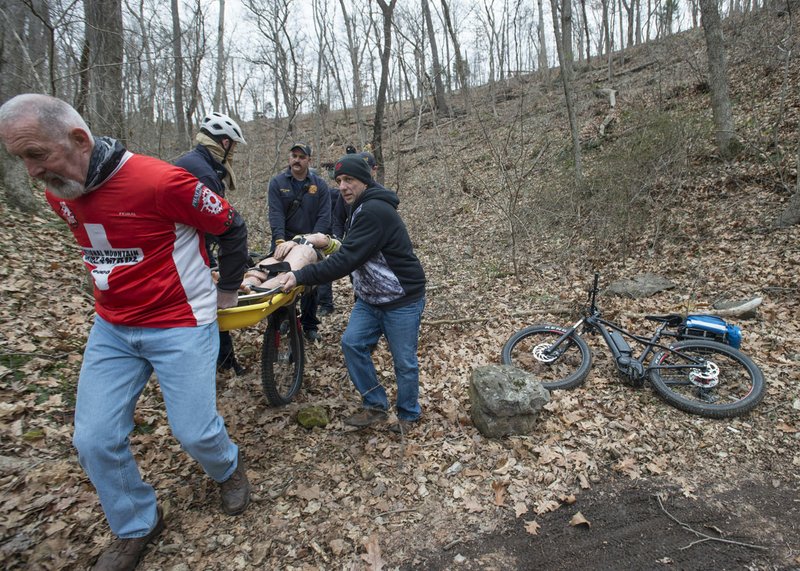
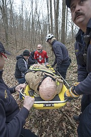
The Bentonville Fire Department trained at the Slaughter Pen mountain bike trails in March. In the simulation, they found a rider with a broken leg and got him safely out of the bike park.
Six members of the department and two members of the Oz Mountain Bike Patrol attended the training, said Matt Perkins, a department captain who facilitated the training.
Training participants practiced using an app, Active 911. Dispatchers ping the caller's cellphone location and send coordinates to emergency responders through the app. The location shows up on a map that includes roadways and trailways. The map also shows and updates the location of fellow responders in real time.
Part of the training was to evaluate the application's accuracy, which proved to be on point.
Two responders biked in from the bottom of a trail in Slaughter Pen while a special response vehicle -- think all-terrain vehicle souped up with medical response equipment -- approached the top of the mountain via a grass service road that was created when the trails were built.
It took only minutes for the responders to find the patient -- a 180-pound training mannequin -- tangled in brush and branches below the trail he theoretically fell off. The location was nearly equal distance from the top and bottom of the trail. A large log was between the patient and way out at the bottom. The steep incline presented a challenge to get to the top.
It wasn't long before the team decided to go down the trail. They then realized they forgot an important piece of equipment, a backboard.
One of the responders threw the mannequin over his shoulder and battled his way over the log and through the brush to get to the trail where a wheel board -- a backboard-looking basket attached to one wheel -- waited.
Responders had to decide whether to take the trail or a shortcut through a small ravine.
"Look at your map," Perkins instructed. "Which way would you go?"
The team decided to wheel the patient on the trail to a more manageable slope. Five people worked to balance the patient as they navigated uneven ground, slick leaves and loose rocks on the slope's side.
"You can see how it could get pretty hairy really quickly," Perkins said.
Riding on
In Eureka Springs' case, the Walton Family Foundation charity agreed to pay for a full-time trail manager, supporting staff and $40,000 in specialized equipment when the city opened its mountain biking trails last year.
"The safety system was about 60 percent in place when the trails opened and is about 80 percent in place now," Huss said. That safety system includes more access routes for ambulances to get near the trails, stretchers capable of attaching to all-terrain vehicles and more 6-foot wide access routes those ATVs can use to get between portions of the trails and the ambulance.
Sauls' back healed, and she is back on the seat of her mountain bike.
"I'm still trying to get back to where I was on a bike," she said. "I'm still not 100 percent there because I get really nervous ... but I've been pushing it and trying to get past being nervous all the time. I'm getting better."
She'll be on the Bentonville West NICA team again, which begins in July.
There's always something new with mountain biking, she said. It teaches riders how to push their limits.
Despite potential dangers, Sauls encourages others to get involved in the sport.
"The more you get out there riding, the more confident you're going to be, and you will wreck," she said. "That's just part of it. Just like in any sport."
Growing trail system
Officials estimate there’s around 325 miles of soft-surface trails in the region, most of which are in Benton and Washington counties but also extend into Carroll and Newton counties.
The NWA Trailblazers, a nonprofit trail development organization, and the Ozark Off Road Cyclists, a nonprofit trail advocacy group, partner with cities and spearhead trail development in the region. Area trails are built using the International Mountain Bicycling Association design standards, said Erin Rushing, executive director of NWA Trailblazers.
The association’s design standards use the same language as ski slopes when signifying the difficulty of each trail. Green is the easiest, blue for intermediate and black for advanced. There are additional signs posted prior to features, such as drops, gaps and jumps, on the more advanced trails to inform riders of the skill needed before they approach them, Rushing said.
The Trailblazers are largely supported through the Walton Family Foundation, which spent $74 million for the construction of 163 miles of trails — soft and hard — from 2007 to 2017, according to the foundation’s website.
Source: Staff report
Growing trail system
Officials estimate there’s around 325 miles of soft-surface trails in the region, most of which are in Benton and Washington counties but also extend into Carroll and Newton counties.
The NWA Trailblazers, a nonprofit trail development organization, and the Ozark Off Road Cyclists, a nonprofit trail advocacy group, partner with cities and spearhead trail development in the region.
Area trails are built using the International Mountain Bicycling Association design standards, said Erin Rushing, executive director of NWA Trailblazers.
The association’s design standards use the same language as ski slopes when signifying the difficulty of each trail. Green is the easiest, blue for intermediate and black for advanced.
There are additional signs posted prior to features, such as drops, gaps and jumps, on the more advanced trails to inform riders of the skill needed before they approach them, Rushing said.
The Trailblazers are largely supported through the Walton Family Foundation, which spent $74 million for the construction of 163 miles of trails — soft and hard — from 2007 to 2017, according to the foundation’s website.
Source: Staff report
NW News on 05/05/2019