The risk for severe weather on Thursday has been upgraded in western portions of Arkansas, the National Weather Service said Wednesday.
Storms that could produce hail as big as golf balls and winds as strong as 60 mph are possible through much of the state on Thursday afternoon and evening, the weather service said in a hazardous weather briefing on Wednesday morning.
"We've seen things escalate in the past 24 to 48 hours," said Jeff Hood, a meteorologist with the National Weather Service office in North Little Rock.
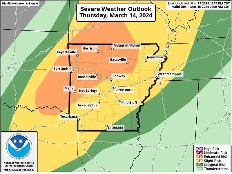
Parts of western Arkansas, including Fayetteville, Fort Smith and Russellville, are at an enhanced risk of severe weather.
An enhanced risk is a level three out of five for severity, the weather service said. The weather service defines an enhanced risk as, compared to a slight risk, an area of greater severe storm coverage with varying levels of intensity.
(QUIZ: Click here to test your severe weather awareness.)
"The environment will be most unstable in the western part of the state, and that is where risk for large hail, damaging winds, and a few tornadoes are most favorable," the briefing stated. "The highest chance of a location seeing a tornado would be across much of western and into northwestern Arkansas as storms initiate and become individual supercells."
Much of Arkansas is at a slight risk for severe weather, including Little Rock, Jonesboro, Conway and Texarkana, the briefing said. That means scattered severe storms are possible.
The storms will be more active on Thursday afternoon and Thursday evening, the weather service said.
"On Thursday morning, we might see some ongoing showers and a few thunderstorms, but we are not expecting to see any severe weather with those," Hood said Wednesday morning.
As the day progresses, Hood said there will be more moisture, gusty winds, and temperatures will be in the 70s and near the 80s for much of Arkansas. Those factors will increase the risk for stronger storms.
"In the early afternoon, in the west, some storms may develop as strong, individual storms as they move. These are the storms we will be watching for large hail and possible tornadoes," the forecaster said.
Later into the evening, the storms are expected to weaken as they move out of the western portion of Arkansas, he said.
"The chance for tornadoes diminishes, but never disappears," Hood said. "The storms will become more widespread and we will focus less on just the threat of hail and tornadoes and focus on seeing any severe weather."
Hood said an evolving threat of these storms is that they could band together and create bigger groups of storms.
"Those groups could hit the same areas and cause pockets of really heavy rainfall and cause locally high rainfall totals, which increases the potential for flash flooding," the forecaster said.
In Little Rock, he said the first half of Thursday morning is not much of a concern.
"We have a chance of seeing more severe weather in the late evening, closer to midnight," he said. "Other warnings might be close or clip into parts of Saline and Pulaski counties, though. So stay aware and read the warnings. We might be right on the edge."
The forecaster said the chance for severe weather would likely last until Friday morning.
The Little Rock Metro area is expected to get around an inch to two inches of rain on Thursday.
"We may be kind of on the sidelines for this severe weather event, but residents should still stay weather aware," Hood said. "And make sure to have a way to receive severe weather alerts during the evening and overnight hours."
He said people in the Little Rock area should pay extra attention to the forecast in the afternoon hours.
"If you're picking up kids from school, or they have sports practice or you have a teenager that drives, just make sure you're paying attention and putting everyone in a position to be safe and set up for success," Hood said.
Looking ahead to next week, the forecaster said there is a potential for a freeze.
"It might not have major impacts, but those that work with plants and home gardeners should know that another round of cold temperatures and below freezing conditions is forecast to be on the way," he said.