UPDATE:
Northwest Arkansas Community College posted on their social media sites that classes will be cancelled Tuesday from the threat of severe wintry weather.
Thaden school posted that the school will delay start of classes until 11:00 a.m.
EARLIER:
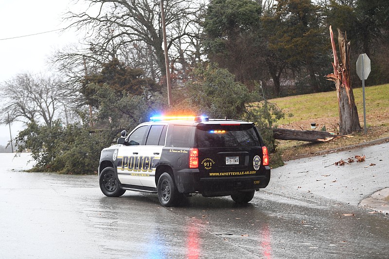
FAYETTEVILLE -- Gusting winds caused some power lines to "pop" Monday morning, disrupting electric service to more than 1,000 area residents.
Ashley Harris, vice president for marketing and communications at Ozarks Electric Cooperative, said the utility began getting reports of power interruptions around 9 a.m. and the number peaked at 990 around 9:30 a.m. Most customers were back online within an hour or two of that time, Harris said, and she expected power to be restored all customers before noon.
Harris said the utility is constantly monitoring weather forecasts and has crews on alert for responding to snow that is possible in the area Tuesday morning.
"Our crews are on standby," she said.
Southwestern Electric Power Co.'s power outage map showed a handful of outages and affected customers in Northwest Arkansas. At 11:25 a.m., SWEPCO was showing about 80 customers without power in the Lowell area, with about 16 customers without power in Fayetteville and fewer than five in the Rogers area.
Pete Snyder, a meteorologist with the National Weather Service in Tulsa, said Monday morning the approaching storm was in the Texas-Oklahoma panhandle area and the bulk of the storm is expected to move north and east of Northwest Arkansas.
"It's proceeding as we expected," Snyder said.
The weather service forecast for Northwest Arkansas calls for rain to transition to snow Monday night and into Tuesday morning. The storm could drop about an inch of snow for Northwest Arkansas on Tuesday, with more possible in higher elevations.
Snyder said the area will see much colder temperatures after the current system passes through, with low temperatures by Saturday dropping to around 10 degrees. Wind chill factors could be below zero, he said. Another storm expected in the area could also bring snow by Friday morning.
Jessica Sigala, Bentonville Electric dispatcher said the utility experienced power outages due to wind blowing trees. Reports of outages began around 9 a.m.
There were two outages that affected homes near the intersections of North East J Street and Tiger Boulevard on the northeast side of town and North West N Street and Robinhood Road on the northwest, according to the outage map.
The outage on the northeast side of Bentonville was caused by a blown fuse, Sigala said. A tree limb caused the fuse to blow twice. Sigala said she was on the phone with a resident and heard the "pop" when the fuse went out the second time.
A tree fell and caused the outage on the northwest side of Bentonville. The report of the fallen tree was received at 9:56 a.m. At 10:50 a.m., a Bentonville Electric crew was working on restoring the lines in the neighborhood.
With the inclement weather due later in the day, Sigala said the electric company is prepared.
"The way the infrastructure is set up, we have duplicity," she said. In most parts of Bentonville, if an area loses power, it is also connected to another source that will supply electricity until the other is fixed.
Benton County Public Services Administrator Jay Frasier said the county has received six reports of trees being down. Frasier said the trees did not all fall in a specific area of the county but "all over" Benton County.
With inclement weather in the forecast, Frasier said the county is preparing to have all crews "out and about" the morning of Jan 9. The teams will be out early to start clearing roads, Frasier said.
Keith Foster, Rogers Police public information officer, said that he had not heard of any obstructions in the roads due to the wind.
County officials say it is not possible to pretreat roads for snow and ice during rain, but they are doing everything they can to prepare for the possibility of wintry weather.