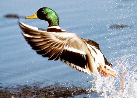
Arkansas Game and Fish Commission staff members conducted the season's final aerial waterfowl survey Jan. 17 in the Arkansas River Valley, Jan. 20 in southwest Arkansas and Jan. 20-24 in the Mississippi Alluvial Valley (Delta). Survey estimates for the Delta totaled about 1 million total ducks in the Delta, including 546,885 mallards. A total of 13,000 of the approximately 25,000 ducks estimated in the Arkansas River Valley were mallards. Observers noted less than 2,000 mallards out of the 18,000-plus ducks in southwest Arkansas.
The Delta mallard population estimate was much lower than the 2010-2020 long-term average, but similar to late January population estimates over the past several years. The total duck population estimate was slightly below the long-term average. Mallards typically make up 61% of all ducks estimated during this survey, and this year's mallard composition was somewhat lower than this average at 52%. Dabbling ducks other than mallards accounted for the overwhelming majority of other ducks estimated.
The highest mallard population estimates in the Arkansas River Valley were in the western portion of the surveyed area in the West Dardanelle and Frog Bayou survey zones. A nonmallard hotspot was noted in the Fourche la Fave survey zone; this concentration consisted mostly of American green-winged teal. This survey's mallard count in southwest Arkansas was the lowest on record since the 2009-10 wintering period.
Luke Naylor, AGFC waterfowl program coordinator, said ducks were distributed among available unmanaged habitats as they have throughout much of the wintering period.
"Certainly, ducks were present on traditional managed habitats, and these habitats remain critically important for sustaining waterfowl populations and hunting opportunity," Naylor said. "However, mallards seemed to be seeking out unmanaged habitats as they have become available this year, likely to avoid hunting pressure while capitalizing on new resources. About half of Delta mallards were using agricultural lands."
*Water levels listed in this report were taken Monday and do not reflect any rainfall Tuesday and Wednesday.
NORTHEAST ARKANSAS
BIG LAKE WMA
North Woods GTR Mast production is good. The Bo Dock gauge is above 237. Target level is 235.5 with 100% flooded.
South Woods GTR Mast production is fair. The 7-mile gauge is above 236.2 feet. Target level is 234.5 feet with 100% flooded.
Simmons Field A good amount of millet and sedge is present. Seed production is very good in the North Unit and middle field. South field was stripped in Japanese millet with strips of wild millet and sedge that did very well. 100% flooded.
DAVE DONALDSON BLACK RIVER WMA
Upper Island GTR Moderate mast crop. Water level is 269.5. Target level is 269.5. 100% flooded.
Lower Island GTR Moderate mast crop. Water level is 268. Target level is 268.5. 100% flooded.
Upper Reyno GTR Moderate mast crop. Water level is 267.8. Target level is 266.9. 100% flooded.
Lower Reyno GTR Moderate mast crop. Water level is 267.3. Target level is 266.3. 100% flooded.
Winchester GTR Moderate mast crop. Water level is 264.9. Target level is 263.7. 100% flooded.
EARL BUSS BAYOU DEVIEW WMA
South Oliver GTR Mast production has been good. The area is 100% flooded with a current gauge reading of 2.0 feet.
Thompson Tract GTR Mast production has been good. The area is 100% flooded with a current gauge reading of 1.7 feet.
Lake Hogue WRA Primarily deep open water habitat. Normal pool level.
SHIREY BAY RAINEY BRAKE WMA
Adam Brake GTR Good abundance of mast crop. Water level is 240.2 with a target level of 100% flooded.
Rainey Brake GTR Good abundance of mast crop. 100% flooded.
Eagle Pond GTR Good abundance of mast crop. 100% flooded.
Phase III Moist-Soil Unit Good wetland-type vegetation. 45% flooded.
Charles Crisp Moist-Soil Unit Good wetland-type vegetation. 100% flooded.
Ward Field Moist-Soil Unit Good wetland-type vegetation. 100% flooded.
River Field Moist-Soil Unit Good wetland-type vegetation. 100% flooded.
ST. FRANCIS SUNKEN LANDS WMA
Hunt Area Mast production is good. Water levels in the huntable areas are dependent on the St. Francis River. The water level at Oak Donnick is 216.13.
Snowden WRA Mixed grasses. 20% flooded.
Payneway WRA Pools A,B, C, and D have mixed smartweed and some mowing has occurred for open water use. Pool A is at 20%. Pool B is at 30%. Pool C is at 40% and Pool D is at 50%.
EAST CENTRAL ARKANSAS
HENRY GRAY HURRICANE LAKE WMA
North GTR Good mast crop. Glaise Creek gauge at 196.39. All structures are closed.
South GTR Fair mast crop. Glaise Creek gauge at 196.39. All structures are open.
REX HANCOCK BLACK SWAMP WMA
Main WMA Good mast crop. 60% flooded.
Wyeville Unit Good stand of millet and native vegetation. 100% coverage.
SHEFFIELD NELSON DAGMAR WMA
Mud Slough GTR Excellent mast crop. 65% flooded.
Apple Lake WRA Fair mast crop. 90% flooded.
Conway George Waterfowl Unit A Good mast crop. 100% flooded.
Conway George Waterfowl Unit B Natural slough area with beneficial wetland plants. 100% flooded.
Conway George Waterfowl Unit C Good stand of millet and native vegetation. 100% flooded.
STEVE N. WILSON RAFT CREEK BOTTOMS WMA
NOTE Raft Creek WMA is will be closed for waterfowl hunting today and Friday.
Unit A Excellent stand of native vegetation. 100% flooded.
Unit B Excellent stand of millet and native vegetation. 100% flooded.
Unit C Good stand of native vegetation. 100% flooded.
Unit D (Youth Area) Good stand of millet and native vegetation. 100% flooded.
Unit E Excellent stand of millet and native vegetation. 100% flooded.
Unit F Excellent stand of millet and native vegetation. 100% flooded.
Unit G Fair stand of millet and native vegetation. 100% flooded.
Unit H (Mobility-impaired blind) Excellent stand of native vegetation. 100% flooded.
Unit I Poor stand of native vegetation. 100% flooded.
Unit J (Cypert Tract) Excellent stand of native vegetation. 100% flooded.
Unit K (Cypert Tract) Excellent stand of native vegetation. 100% flooded.
Unit L (Cypert Tract) Excellent stand of native vegetation. 50% flooded.
CENTRAL ARKANSAS
CRAIG D. CAMPBELL LAKE CONWAY RESERVOIR
Habitat and water levels are normal on both Pierce and Dix creeks.
BELL SLOUGH WMA
Bell Slough GTR Moderate mast crop. 100% flooded.
Palarm Creek WRA Units 1 & 2 Millet was planted as a cover crop within the moist-soil units. 100% flooded.
CYPRESS BAYOU WMA
Hunt Area Good mast crop. 100% flooded.
Red Cut Slough Tract Unit 1 Good stand of millet and native vegetation. Water level 100%.
Unit 2 Excellent stand of millet and native vegetation. Water level 100%.
Unit 3 Good stand of millet and native vegetation. Water level 100%.
Unit 4 Good stand of native vegetation. Water level 100%.
Unit 5 Good stand of native vegetation. Water level 80%.
Unit 6 Good stand of native vegetation. Water level 80%.
HARRIS BRAKE WMA
Harris Brake Upper Unit Good mast in the GTR. 100% flooded.
Harris Brake Lower Unit Good mast in the GTR. 95% flooded.
HOLLAND BOTTOMS WMA
Hunt Area Good mast. 50% flooded.
Lake Pickthorne WRA Excellent conditions. East cell 100% flooded. West Cell is 100% flooded.
SOUTHWEST ARKANSAS
DR. LESTER SITZES III BOIS D' ARC WMA
Bois d'Arc Lake WRA Closed to hunting. Normal.
Red Slough WRA Closed to hunting. Water level 55%.
GTR Good mast production. Water level 80%.
Little Grassy Habitat is good. Water level 70%.
MILLWOOD LAKE Habitat is good. Water level 261.07.
OZAN WMA
Unit 1 Habitat good. 40% flooded.
Unit 2 Habitat good. 0% flooded.
Unit 3 Habitat good. 45% flooded.
Unit 4 Habitat good. 0% flooded.
Unit 5 Habitat good. 15% flooded.
SULPHUR RIVER WMA
Mercer Bayou Habitat conditions are fair. Water level is low. No boat access.
Henry Moore WRA Closed to hunting. 35% flooded.
SOUTHEAST ARKANSAS
BERYL ANTHONY LOWER OUACHITA WMA The WMA has good hard mast production. The WMA is about 60% flooded.
FREDDIE BLACK CHOCTAW ISLAND WMA DEER RESEARCH AREA Habitat conditions are good. There is variable flooding associated with the Mississippi River. Use extreme caution when boating on the river.
TRUSTEN HOLDER Habitat conditions good. Flooding is river dependent.
SEVEN DEVILS SWAMP WMA Habitat conditions good. Fully flooded.
CUT-OFF CREEK WMA
Hunt Area Habitat conditions are good. Fully flooded.
Pigeon Creek WRA Habitat conditions are good. Fully flooded.
BAYOU METO WMA
Upper Vallier GTR Good habitat. Water level 180.66 feet, full pool at 180 feet.
Lower Vallier GTR Good habitat. Water level 179.42 feet, full pool at 179 feet.
Government Cypress GTR Good habitat. Water level 180.21 feet, full pool at 179 feet.
Buckingham Flats GTR Good habitat. 176.78 msl.
Temple Island GTR Good habitat. Water level 184.23
Canon Brake Good habitat. 177.05 msl. Full pool at 177 msl.
Halowell WRA Excellent habitat. Staggered flooding of units. 75% flooded. Good numbers of ducks on south units
Wrape Plantation WRA Excellent habitat. Staggered flooding of units.
NORTHWEST ARKANSAS
DARDANELLE WMA
McKennon Bottoms Heavy stand of perennial vegetation due for disking next spring. 100% flooded.
Potter's Pothole Hartman Waterfowl Unit Some planted millet, good stand of native millet, sprangle top and panic grasses. 100% flooded and currently pumping.
OZARK POOL
Dyer Lake Cells Fair stand of nutsedge and toothcup smartweed, and sprangle top. Unit 3 was impacted by summer flooding and needs disturbance that is scheduled for next year. Units 1 and 2 are 100% flooded. Unit 3 is 100% flooded.
NIMROD LLOYD MILLWOOD WMA
Nimrod GTR Excellent mast crop with a mix of moderate to good stands of desirable native vegetation throughout the open lands. 100% flooded.
ED GORDON POINT REMOVE WMA
Little Hole (Unit 1) Natural vegetation. 100% flooded.
Willow Island Planted Japanese millet. 100% flooded.
Red Gate Native vegetation. 100% flooded.
Pig Trough (Units 4 and 5) Planted Japanese and Chiwapa millet and native vegetation. 100% flooded.
Cedar Ridge (Unit 6) Natural vegetation and Chiwapa millet. 100% flooded.
Duck Trap Natural vegetation. 100% flooded.
Unit 7A Japanese millet, native vegetation. 100% flooded.
Unit 7B Natural vegetation. 100% flooded.
Unit 8A Natural vegetation. 100% flooded.
Unit 8B Japanese and Chiwapa millet, native vegetation. 100% flooded.
Unit 8C Japanese millet. 100% flooded.
Unit 9 Japanese millet. 100% flooded.
Controversy Corner (Unit 10) Natural vegetation. 100% flooded.
Remmel Marsh Japanese millet. 100% flooded.
Mud Pond (Unit 12) Natural vegetation. 100% flooded.
Turkey Pond (Unit 13A) Natural vegetation and Japanese millet. 100% flooded.
Turkey Pond (Unit 13B) Natural vegetation. 100% flooded.
Turkey Pond (Unit 13C) Natural vegetation, Japanese millet and Chiwapa millet. 100% flooded.
Teeny Pond (Unit 14) Natural vegetation. 100% flooded.
Salt Lick (Unit 15) Native vegetation. Water level 100%.
Bobby's Pond (Unit 16) Japanese millet. 100% flooded.
Race Track (Unit 17) Natural vegetation. 100% flooded.
FROG BAYOU WMA
Unit 1 Sprangle top, wild millet, smartweed and nutsedge. 100% flooded.
Unit 2 Good stand of barnyard grass and nutsedge. 50% flooded.
Unit 3 Smartweed, toothcup, nutsedge, barnyard grass, sprangle top and duck potato. 100% flooded.
Unit 4 Barnyard grass, sprangle top, annual smartweed, nutsedge and crabgrass. 100% flooded.
Unit 5 Sprangle top, wild millet, smartweed, knotgrass, nutsedge and duck potato. 100% flooded.
Unit 6 Barnyard grass, smartweed, crabgrass and sprangle top. 100% flooded.
Unit 7 Lower end of unit planted with millet, upper end with barnyard grass, sprangle top and smartweed. 100% flooded and scheduled to pump full the first week of December.
GALLA CREEK WMA
Galla Creek GTR Moderate stand of native vegetation, including a mixture of barnyard grass and sprangle top. 100% flooded.
PETIT JEAN RIVER WMA
Santa Fe GTR Excellent mast crop. 100% flooded.
Sore-Head Moist Soil Unit Moderate to good stands of desirable native vegetation throughout. 100% flooded.
Slaty Crossing Moist-Soil Unit Due to ongoing waterfowl habitat enhancement projects, most of this unit is bare ground. 90% flooded.
Olin Cain Moist-Soil Unit 25% native vegetation and 100% flooded.
Black Lands Moist-Soil Unit Poor to great stands of desirable native vegetation throughout. Great mast crop in the wooded areas. 100% flooded.
Black Lands Duck Area Excellent mast in the wooded sections. Moderate to great stands of desirable native vegetation mixed throughout. 100% flooded.
Pullen Pond Due to ongoing waterfowl habitat enhancement projects, parts of the southern and western sections are bare ground. The western section of this area has spotted sections of great desirable native vegetation. The northern section produced poor stands of native vegetation. Water level 100%.
Pond Creek GTR Excellent mast crop with excellent stands of desirable native vegetation in the open lands. 0% flooded.
Slaty GTR Excellent mast crop. 10% flooded.
Black Lands Duck Area Millet, native vegetation. 100% flooded.
Sports on 01/30/2020