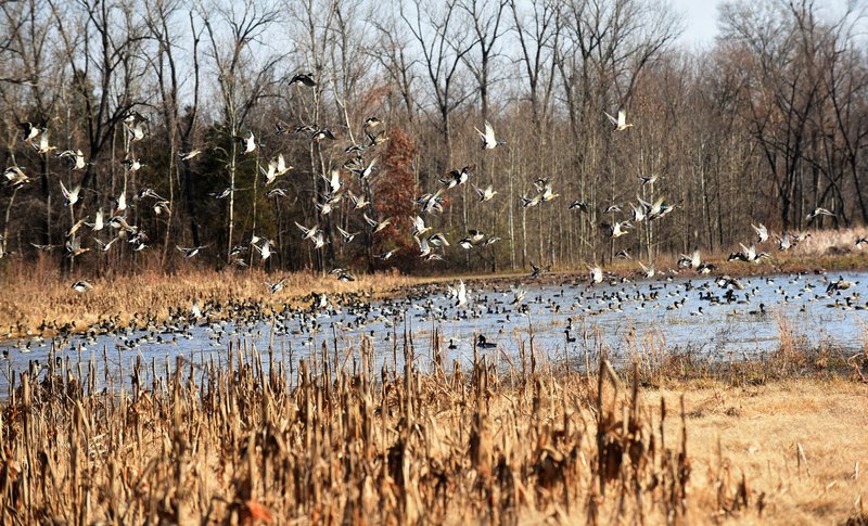
More of Arkansas' ducks were found in the middle to northeastern parts of the state, according to the most recent Arkansas Game and Fish Commission aerial survey.
Observers during the Dec. 16-20 survey flights saw more than half of the mallards counted in the Delta in the Cache, Black-Upper White and Little River survey zones. Many of these ducks were in the northern portions of these zones. Mallard hot spots were limited to portions of southern Jackson and western Craighead counties along with Big Lake National Wildlife Refuge and Big Lake Wildlife Management Area.
The most telling number about the 2019-2020 water season, though, was the count of nearly 1 million light geese (lesser snow/blue and Ross's) and about 158,000 greater white-front geese in Arkansas' portion of the Mississippi Alluvial Valley (or Delta), compared with an estimated 898,656 total ducks in the same region.
On-the-ground anecdotal reporting indicated a "tremendous" number of snow geese in the Walnut Ridge area just off U.S. Highway 67 in the northern most reach of the state, along with continuous good reports of both snow geese and speckle bellies (greater white-fronted geese) into the central and southern portions of the Arkansas Delta. Meanwhile, anecdotal reports of ducks in the area ranged from poor to good on private lands.
*Water levels listed in this report were taken Monday and do not reflect any rainfall Tuesday and Wednesday.
NORTHEAST ARKANSAS
BIG LAKE WMA
North Woods GTR Mast production is good. The Bo Dock gauge currently reads 236.4. Target level is 235.5 with 100% flooded.
South Woods GTR Mast production is fair. The 7-mile gauge is currently at 235.5 feet. Target level is 234.5 feet with 100% flooded.
Simmons Field A good amount of millet and sedge is present. Seed production is very good in the North Unit and middle field. South field was stripped in Japanese millet with strips of wild millet and sedge that did very well. 100% flooded.
DAVE DONALDSON BLACK RIVER WMA
Upper Island GTR Moderate mast crop. Water level is 269.75. Target level is 269.5. 100% flooded.
Lower Island GTR Moderate mast crop. Water level is 268.65. Target level is 268.5. 100% flooded.
Upper Reyno GTR Moderate mast crop. Water level is 267.375. Target level is 266.9. 100% flooded.
Lower Reyno GTR Moderate mast crop. Water level is 266.5. Target level is 266.3. 100% flooded.
Winchester GTR Moderate mast crop. Water level is 263.55. Target level is 263.7. 100% flooded.
EARL BUSS BAYOU DEVIEW WMA
South Oliver GTR Mast production has been good. The area is 100% flooded with a current gauge reading of 1 foot. Water is rising in the GTR.
Thompson Tract GTR Mast production has been good. The area is 100% flooded with a current gauge reading of 1.2 feet.
Lake Hogue WRA Primarily deep open water habitat. Normal pool level.
SHIREY BAY RAINEY BRAKE WMA
Adam Brake GTR Good abundance of mast crop. Water level is 240.4 with a target level of 100% flooded.
Rainey Brake GTR Good abundance of mast crop. 100% flooded.
Eagle Pond GTR Good abundance of mast crop. 100% flooded.
Phase III Moist-Soil Unit Good wetland-type vegetation. 45% flooded.
Charles Crisp Moist-Soil Unit Good wetland-type vegetation. 90% flooded.
Ward Field Moist-Soil Unit Good wetland-type vegetation. 90% flooded.
River Field Moist-Soil Unit Good wetland-type vegetation. 95% flooded.
ST. FRANCIS SUNKEN LANDS WMA
Hunt Area Mast production is good. Water levels in the huntable areas are dependent on the St. Francis River. The water level at Oak Donnick is 213.18.
Snowden WRA Mixed grasses. 20% flooded.
Payneway WRA Pools A,B, C, and D have mixed smartweed and some mowing has occurred for open water use. Pool A is at 0%. Pool B is at 0%. Pool C is at 20% and Pool D is at 35%.
EAST CENTRAL ARKANSAS
HENRY GRAY HURRICANE LAKE WMA
North GTR Good mast crop. Glaise Creek gauge at 193.65. All structures are closed.
South GTR Fair mast crop. Glaise Creek gauge at 193.65. All structures are open.
REX HANCOCK BLACK SWAMP WMA
Main WMA Good mast crop. 40% flooded.
Wyeville Unit Good stand of millet and native vegetation. 100% coverage.
SHEFFIELD NELSON DAGMAR WMA
Mud Slough GTR Excellent mast crop. 50% flooded.
Apple Lake WRA Fair mast crop. 75% flooded.
Conway George Waterfowl Unit A Good mast crop. 100% flooded.
Conway George Waterfowl Unit B Natural slough area with beneficial wetland plants. 100% flooded.
Conway George Waterfowl Unit C Good stand of millet and native vegetation. 100% flooded.
STEVE N. WILSON RAFT CREEK BOTTOMS WMA
NOTE The White River at the Georgetown gauge was 16.4 feet on Tuesday. All on-site permit draws for Saturdays and Sundays have been reinstated.
Unit A Excellent stand of native vegetation. 100% flooded.
Unit B Excellent stand of millet and native vegetation. 100% flooded.
Unit C Good stand of native vegetation. 100% flooded.
Unit D (Youth Area) Good stand of millet and native vegetation. 100% flooded.
Unit E Excellent stand of millet and native vegetation. 100% flooded.
Unit F Excellent stand of millet and native vegetation. 100% flooded.
Unit G Fair stand of millet and native vegetation. 90% flooded.
Unit H (Mobility-impaired blind) Excellent stand of native vegetation. 100% flooded.
Unit I Poor stand of native vegetation. 90% flooded.
Unit J (Cypert Tract) Excellent stand of native vegetation. 100% flooded.
Unit K (Cypert Tract) Excellent stand of native vegetation. 100% flooded.
Unit L (Cypert Tract) Excellent stand of native vegetation. 80% flooded.
CENTRAL ARKANSAS
CRAIG D. CAMPBELL LAKE CONWAY RESERVOIR
Habitat and water levels are normal on both Pierce and Dix creeks.
BELL SLOUGH WMA
Bell Slough GTR Moderate mast crop. 100% flooded.
Palarm Creek WRA Units 1 & 2 Millet was planted as a cover crop within the moist-soil units. 100% flooded.
CYPRESS BAYOU WMA
Hunt Area Good mast crop. 85% flooded.
Red Cut Slough Tract Unit 1 Good stand of millet and native vegetation. Water level 55%.
Unit 2 Excellent stand of millet and native vegetation. Water level 100%.
Unit 3 Good stand of millet and native vegetation. Water level 100%.
Unit 4 Good stand of native vegetation. Water level 100%.
Unit 5 Good stand of native vegetation. Water level 50%.
Unit 6 Good stand of native vegetation. Water level 50%.
HARRIS BRAKE WMA
Harris Brake Upper Unit Good mast in the GTR. 100% flooded.
Harris Brake Lower Unit Good mast in the GTR. 100% flooded.
HOLLAND BOTTOMS WMA
Hunt Area Good mast. 35% flooded.
Lake Pickthorne WRA Excellent conditions. East cell 100% flooded. West Cell is 85% flooded.
SOUTHWEST ARKANSAS
DR. LESTER SITZES III BOIS D' ARC WMA
Bois d'Arc Lake WRA Closed to hunting. Normal.
Red Slough WRA Closed to hunting. Water level 55%.
GTR Good mast production. Water level 75%.
Little Grassy Habitat is good. Water level 60%.
MILLWOOD LAKE Habitat is good. Water level 259.46.
OZAN WMA
Unit 1 Habitat good. 0% flooded.
Unit 2 Habitat good. 0% flooded.
Unit 3 Habitat good. 0% flooded.
Unit 4 Habitat good. 0% flooded.
Unit 5 Habitat good. 0% flooded.
SULPHUR RIVER WMA
Mercer Bayou Habitat conditions are fair. Water level is low. No boat access.
Henry Moore WRA Closed to hunting. 30% flooded.
SOUTHEAST ARKANSAS
BERYL ANTHONY LOWER OUACHITA WMA The WMA has good hard mast production. The only water on the WMA currently is in the sloughs and in the oxbow lakes.
FREDDIE BLACK CHOCTAW ISLAND WMA DEER RESEARCH AREA Habitat conditions are good. There is variable flooding associated with the Mississippi River. Use extreme caution when boating on the river.
TRUSTEN HOLDER Habitat conditions good. Flooding is river dependent.
SEVEN DEVILS SWAMP WMA Habitat conditions good. Fully flooded.
CUT-OFF CREEK WMA
Hunt Area Habitat conditions are good. Fully flooded.
Pigeon Creek WRA Habitat conditions are good. Fully flooded.
BAYOU METO WMA
Upper Vallier GTR Good habitat. Water level 179.19 feet, full pool at 180 feet.
Lower Vallier GTR Good habitat. Water level 179.13 feet, full pool at 179 feet.
Government Cypress GTR Good habitat. Water level 179.27 feet, full pool at 179 feet.
Buckingham Flats GTR Good habitat. 176.52 msl. First phase of pumping completed.
Temple Island GTR Good habitat. Water level 184.13
Canon Brake Good habitat.176.50 msl. Full pool at 177 msl.
Halowell WRA Excellent habitat. Staggered flooding of units. 60% flooded. Good numbers of ducks on south units
Wrape Plantation WRA Excellent habitat. Staggered flooding of units.
NORTHWEST ARKANSAS
DARDANELLE WMA
McKennon Bottoms Heavy stand of perennial vegetation due for disking next spring. 100% flooded.
Potter's Pothole Hartman Waterfowl Unit Some planted millet, good stand of native millet, sprangle top and panic grasses. 100% flooded and currently pumping.
OZARK POOL
Dyer Lake Cells Fair stand of nutsedge and toothcup smartweed, and sprangle top. Unit 3 was impacted by summer flooding and needs disturbance that is scheduled for next year. Units 1 and 2 are 100% flooded. Unit 3 is 100% flooded.
NIMROD LLOYD MILLWOOD WMA
Nimrod GTR Excellent mast crop with a mix of moderate to good stands of desirable native vegetation throughout the open lands. 100% flooded.
ED GORDON POINT REMOVE WMA
Little Hole (Unit 1) Natural vegetation. 100% flooded.
Willow Island Planted Japanese millet. 100% flooded.
Red Gate Native vegetation. 100% flooded.
Pig Trough (Units 4 and 5) Planted Japanese and Chiwapa millet and native vegetation. 100% flooded.
Cedar Ridge (Unit 6) Natural vegetation and Chiwapa millet. 100% flooded.
Duck Trap Natural vegetation. 100% flooded.
Unit 7A Japanese millet, native vegetation. 100% flooded.
Unit 7B Natural vegetation. 100% flooded.
Unit 8A Natural vegetation. 100% flooded.
Unit 8B Japanese and Chiwapa millet, native vegetation. 100% flooded.
Unit 8C Japanese millet. 100% flooded.
Unit 9 Japanese millet. 100% flooded.
Controversy Corner (Unit 10) Natural vegetation. 100% flooded.
Remmel Marsh Japanese millet. 100% flooded.
Mud Pond (Unit 12) Natural vegetation. 100% flooded.
Turkey Pond (Unit 13A) Natural vegetation and Japanese millet. 100% flooded.
Turkey Pond (Unit 13B) Natural vegetation. 100% flooded.
Turkey Pond (Unit 13C) Natural vegetation, Japanese millet and Chiwapa millet. 100% flooded.
Teeny Pond (Unit 14) Natural vegetation. 100% flooded.
Salt Lick (Unit 15) Hative vegetation. Water level 100%.
Bobby's Pond (Unit 16) Japanese millet. 100% flooded.
Race Track (Unit 17) Natural vegetation. 100% flooded.
FROG BAYOU WMA
Unit 1 Sprangle top, wild millet, smartweed and nutsedge. 100% flooded.
Unit 2 Good stand of barnyard grass and nutsedge. 50% flooded.
Unit 3 Smartweed, toothcup, nutsedge, barnyard grass, sprangle top and duck potato. 100% flooded.
Unit 4 Barnyard grass, sprangle top, annual smartweed, nutsedge and crabgrass. 100% flooded.
Unit 5 Sprangle top, wild millet, smartweed, knotgrass, nutsedge and duck potato. 100% flooded.
Unit 6 Barnyard grass, smartweed, crabgrass and sprangle top. 100% flooded.
Unit 7 Lower end of unit planted with millet, upper end with barnyard grass, sprangle top and smartweed. 100% flooded and scheduled to pump full the first week of December.
GALLA CREEK WMA
Galla Creek GTR Moderate stand of native vegetation, including a mixture of barnyard grass and sprangle top. 85% flooded.
PETIT JEAN RIVER WMA
Santa Fe GTR Excellent mast crop. 100% flooded.
Sore-Head Moist Soil Unit Moderate to good stands of desirable native vegetation throughout. 100% flooded.
Slaty Crossing Moist-Soil Unit Due to ongoing waterfowl habitat enhancement projects, most of this unit is bare ground. 90% flooded.
Olin Cain Moist-Soil Unit 25% native vegetation and 100% flooded.
Black Lands Moist-Soil Unit Poor to great stands of desirable native vegetation throughout. Great mast crop in the wooded areas. 100% flooded.
Black Lands Duck Area Excellent mast in the wooded sections. Moderate to great stands of desirable native vegetation mixed throughout. 100% flooded.
Pullen Pond Due to ongoing waterfowl habitat enhancement projects, parts of the southern and western sections are bare ground. The western section of this area has spotted sections of great desirable native vegetation. The northern section produced poor stands of native vegetation. Water level 100%.
Pond Creek GTR Excellent mast crop with excellent stands of desirable native vegetation in the open lands. 90% flooded.
Slaty GTR Excellent mast crop. 10% flooded.
Black Lands Duck Area Millet, native vegetation. 100% flooded.
Sports on 01/02/2020