Some U.S. Army Corps of Engineers' parks along the Arkansas River remain closed because of record flooding this spring.
"Several parks along the Arkansas River were severely damaged during the flood," said Col. Eric M. Noe, commander of the Corps' Little Rock District. "We're asking visitors to please be patient as we determine the way forward in making repairs and opening parks, as well as restoring the commercial navigation system and hydropower generation."
According to a news release, the following facilities along the Arkansas River will remain closed until the Corps has the resources to make sufficient repairs and the parks are determined to be safe: Sheppard Island Park, adjacent to Emmett Sanders Lock & Dam near Pine Bluff; Rising Star Park near Pine Bluff; Toad Suck Ferry Damsite Park near Conway; Cherokee Park near Morrilton; and Riverview Park, located just below the Lake Dardanelle dam near Russellville.
The following facilities will remain partially open with limited services: Old Post Park, Clear Creek (day use only), Tar Camp (day use only), and Notrebes Bend.
Jay Townsend, chief of public affairs at the Corps' Little Rock District, said it's difficult to estimate when the work will be completed. He said the Corps is using maintenance and operations money from fiscal 2019 to begin the repair work. Additional maintenance and operations funds will be available in October for fiscal 2020 and can be used to continue repairs, he said.
"We may end up receiving some additional funds on down the road," he said. "We're assessing the parks. We've got teams trying to figure out how many picnic tables we'll need, how many roofs have to be replaced. That kind of thing."
"The floodwaters destroyed roads, electric lines, RV power outlets, septic tanks and waterlines in our parks," Noe said. "The damage we know about is pretty extensive. Some parks may not offer the same services when they reopen."
A complete list of closed parks in the Corps' Little Rock District can be found at: swl.usace.army.mil. Hundreds of other Corps parks in the region remain open for business as usual, and reservations can be made at recreation.gov, according to the news release.
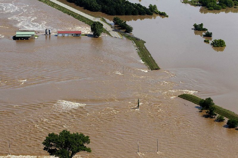
Heavy rainfall in Kansas and Oklahoma this spring led the Corps to release water from reservoirs in both states that eventually made its way down the Arkansas River, leading to severe flooding in some parts of Arkansas. Hundreds of homes and businesses were flooded as the water worked its way from western Arkansas through central Arkansas and into the southeast part of the state.
The Arkansas River begins in the Rocky Mountains in Leadville, Colo. By the time it's near Dodge City, Kan., the Arkansas River is little more than a prairie stream.
Near Muskogee, Okla., the Arkansas River intersects with the Verdigris River, which is part of the McClellan-Kerr Arkansas River Navigation System.
From there, the navigation system continues along the Arkansas River -- across Arkansas -- to the Mississippi River, providing a minimum 9-foot-deep channel for barge traffic.
The system includes 18 locks and dams that artificially deepen the Arkansas and Verdigris rivers along the entire 445-mile route, "creating a staircase from the Mississippi River up to Catoosa, Okla.," according to the Oklahoma Historical Society.
Metro on 09/06/2019