Fresh air and healthy exercise are benefits of trekking along a wilderness trail. Rewards are three-fold when the path leads to a fabulous view from a bluff or ridge top.
Dozens of trails in the Ozarks offer postcard-worthy views from on high. Several are reached with an easy to moderate hike, with trails short enough to enjoy more than one view during a day of hiking.
Here is a sampler of routes that lead to lofty views of streams, forests and meadows.
• Kings River Overlook Nature Trail may be the region's shortest and easiest hike that leads to a scenic vista. The walk from the parking area to the overlook is a mere one-half mile of level walking.
The trail itself is a pleasant stroll. The view at the end is worthy of a framed photograph or being captured on canvas by brush-wielding artists. Pack a picnic basket for a lunch with a five-star view.
The overlook is in the heart of the 14,000-acre McIlroy Madison County Wildlife Management Area. To reach Kings River Overlook Nature Trail, travel Arkansas 23 to the wildlife management area entrance midway between Eureka Springs and Huntsville.
The parking area is about five miles from the entrance along gravel roads. Follow signs to the parking area. The trail begins at a gate with an information sign.
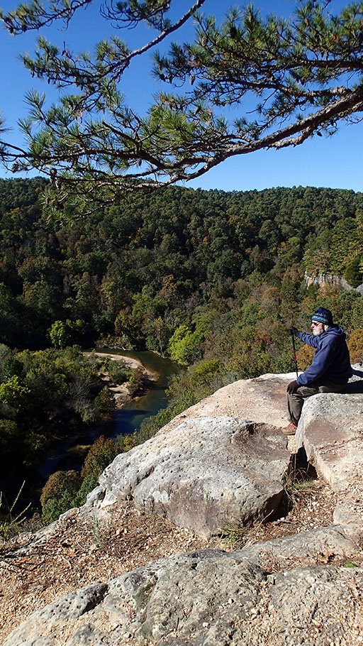
• War Eagle Trail at Withrow Springs State Park five miles north of Huntsville guides hikers up a bluff beside the War Eagle River to long views of the stream and river valley. Forests, pastures and the river make for scenic viewing along the route.
Hiking starts at a parking area where Arkansas 23 crosses the War Eagle River. The one-and-a-half mile trail starts under the highway bridge and meanders upstream.
Caution is urged on parts of the trail that are close to the bluff edge. The trail passes a large cave. Entry isn't allowed because all caves in Arkansas on public land are closed to prevent the spread of white-nose syndrome, a malady that is fatal to bats.
The last half-mile of trail is a moderate climb with places to leave the path and enjoy cliff-top views. There's even a rest bench at the top.
Hikers can return to the trailhead or go a little farther and cross Arkansas 23 to join the Dogwood Trail. Dogwood Trail is 1.1 miles of hiking surrounded by forest.
It would be easy to visit Kings River Overlook and War Eagle trails in the same day.
• Buffalo River Trail offers as many jaw-dropping views as there are bends in the stream. A popular hike with a view starts at Steel Creek campground and ends two miles later at the lip of a bluff.
It's a moderate climb, but the view from the top is worth the leg work.
The route is sort of horseshoe shaped. The last mile brings hikers close enough to Steel Creek campground to see it from the bluff top.
• Hawksbill Crag may be the most popular hike with a view in the entire Ozarks. A 1.5-mile trail leads to a rock outcrop shaped like a hawk's beak or a turtle's head. The view of the crag is incredible at this spot in the Upper Buffalo Wilderness.
The trail is mostly downhill from the small parking area to the crag, for a 3-mile round-trip hike. To get there, follow Arkansas 21 in Boxley to an overpass that crosses the Buffalo National River. Turn right on gravel Cave Mountain Road at the bridge and go five miles to the parking area. The road is steep and rough.
Try to visit during the week to avoid the crowd, especially on weekends with nice weather.
• White Rock Mountain in the Ozark National Forest may offer the longest views of any high point in the Ozarks. Some of the views are seen by walking only a few steps from the car, or see more on a 2-mile trail around the mountain top.
On a clear day, visitors can look south and see all the way to the Ouachita Mountains. Campsites and cabins are also located at the top.
White Rock Mountain is remote. There are two or three routes to get there. One is to drive Arkansas 23 south from Huntsville to Cass. Turn right at Cass on White Rock Mountain Road. It's 16 miles of gravel to the top.
More to see
Devil’s Ice Box Trail at Roaring River State Park near Cassville, Mo., offers ridgetop views of the park. It’s a one-and-a-half mile loop trail with one steep climb. The trail starts near the trout hatchery.
Goat Trail visits Big Bluff high above the Buffalo National River. The six-mile round-trip hike starts at the Center Point trailhead north of Ponca. Three miles from the trailhead, look for an open area in the woods with a big campfire ring. The Goat Trail heads off to the right about one-quarter mile then goes along the bluff.
The hike is rated difficult.
Yellow Rock Trail at Devil’s Den State Park leads to an overlook with views of Lee Creek and acres of forest. The overlook is seen about half-way into the hike. Visitors can hike to the overlook and back, or loop along all three miles of the Yellow Rock Trail.
Source: Staff report
Sports on 11/27/2018