Wind and wintry weather brought some snow and power outages to Northwest Arkansas and the River Valley early Friday, but officials said it was less serious than expected.
The forecast for the next several days, however, remains threatening.
"We were expecting 2½ inches and all we got was this dusting," Jeff Crowder, Washington County's road superintendent, said Friday morning. "We got a little bit on the roads but it's not looking too bad."
Crowder said Road Department crews were out applying an ice melting solution and a salt mix to a few spots, but overall road conditions were good Friday morning.
Benton County Communications Director Melody Kwok said the biggest concern is the upcoming storm system Sunday, which is forecast to bring negative temperatures through the coming week. Kwok said officials are encouraging people to stay indoors as much as possible, as the subzero temperatures can cause frostbite and reduce vehicle function.
The Benton County Road Department pre-treated the roads with a salt and sand mixture Thursday night and reapplied it this morning after Thursday night's rain, Kwok said. Crews are continually treating bridges and overpasses while monitoring conditions, she said.
Temperatures that soared all the way into the 50s on Thursday had dropped into the low 20s by Friday morning.
The National Weather Service issued a winter weather advisory for Friday morning, with less than one inch of snow expected between 6 a.m. and 10 a.m. and wind gusts of up to 40 mph.
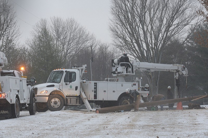
More than 2,000 customers in Benton County were reported to be without power at one point Friday morning, though by 11 a.m., that number had sunk to 1,003, according to the website poweroutage.us. Washington County had 30 customers without power at 11 a.m.
Olivia Tyler, public affairs manager for Northwest Arkansas National Airport, said both the runway and taxiways are cleared, and that any cancellations and delays are decided by airlines.
The airport released the following statement on social media: "Certain flights out of Northwest Arkansas National Airport are experiencing delays lasting approximately 30 minutes on average. Because the snow event at XNA was not severe, our operations team was able to quickly clear the runway and taxiways to keep them fully operational. Any other delays or cancellations are beyond the control of the airport and may be attributed to challenges faced by airlines and their ground crews, or inclement weather at other connecting hubs. If you are traveling, be sure to check the status of your flight with your respective airline."
Schools across Northwest Arkansas announced on Thursday their intentions to be closed Friday.
Locally, some highways were showing snowy conditions this morning, according to the Arkansas Department of Transportation. Interstate 49 was showing snowy conditions from Fayetteville north to the Missouri border and U.S. 412 was snowy across Washington County and east to Huntsville.
Conditions were similar in the River Valley. Sebastian County Emergency Management reported Friday "blizzard like precipitation of a sleet/snow mix" that is falling and collecting.
"Roadways will be covered in areas that are not heavily traveled, but with the temps of the roadways dropping and being wet, be mindful of bridges and overpasses as the day goes on," Sebastian County Emergency Management posted on social media.
Sgt. Matt Ray with the Springdale Police Department said there had been a few traffic problems in the city but nothing serious. Lt. Anthony Murphy with the Fayetteville Police Department said there were four accidents reported Friday morning, which he said was "less than a normal sunny day."
There were four motor vehicle collisions in Rogers between 8 and 9 a.m., according to Keith Foster, Rogers Police public information officer.
John Luther, director of emergency management for Washington County, said the extended forecast, while still in flux, is still very threatening.
"We got some precipitation in the form of snow this morning but what's yet to come is the frigid temperatures and more snow Saturday night into Monday," Luther said. Luther said the early forecasts show snow accumulation ranging from one to two inches in some models, up to seven or eight in other models.
According to the National Weather Service in Tulsa, another round of snow is expected Sunday into Monday as another, stronger cold front pushes through the region. A high chance for snow impacts exists across much of eastern Oklahoma and Northwest Arkansas and the River Valley during the Sunday to Monday time frame, caused by notable snow accumulations and potential blowing and drifting snow. Forecast snow accumulations will continue to be refined over the coming days, according to the weather service.
An extended period of sub-freezing temperatures is expected over much of eastern Oklahoma, Northwest Arkansas and the River Valley following both today's and Saturday's frontal passages, the forecast continues. The coldest temperatures will follow the Saturday front, likely Sunday night through Monday night. Strong and gusty north winds will lead to periods of well below zero wind chill values, which may be life- threatening if unprepared.
Luther said the cold temperatures will present different hazards and urged area residents to take precautions against freezing pipes and to limit travel and outdoor activities.
"Some people have to get out for their jobs," Luther said. "They generally know to dress warmly, wear protection for their hands and their heads, and to take extra time to drive and choose routes to avoid problems like hills, curves and shady areas on roads. Whatever is on the ground for the next week is going to freeze. If there's any melting during the day it will refreeze after dark. If you're going to be driving, you should just assume there's going to be ice."
Luther said anyone driving in the next few days should plan on taking more time to reach their destination and have routes planned to avoid hills as much as possible. He also asked that drivers be conscious of the dangers to emergency services workers if they are passing an accident site, a fire, or other situations where emergency workers are present.
"I know people want to slow down and see what's happening," Luther said. "But these police, fire and other emergency services people are focused on trying to help the people involved in whatever the situation may be. There's lots of noise and lots of activity and they can't be focused on what people driving by are doing."