UPDATE:
Benton County extended its 24-hour burn ban on Tuesday morning, according to a news release from the county.
An additional 22 counties in Arkansas had burn bans in place as of Tuesday morning, including Carroll, Madison, Crawford, Franklin and Sebastian counties.
EARLIER:
Record high temperatures and dry conditions have put much of Northwest Arkansas at risk of grassland fires, according to the National Weather Service office in Tulsa.
Sunday and Monday saw record high temperatures for each day at Drake Field in Fayetteville. Sunday’s high temperature reached 78, and Monday’s was 77. The previous record high temperature for Feb. 25 was 73 degrees in 1950 while the previous high for Feb. 26 was 74 degrees, recorded in 1976.
Record highs are forecast for today as well, according to Joe Sellers, meteorologist with the weather service.
The forecast for today calls for a high in the low 80s. For Feb. 27, the current record high temperature is 75 degrees, also set in 1976.
After Tuesday, Sellers said, temperatures will drop, but the fire risk will remain.
“Tuesday night will bring much more seasonable temperatures,” Sellers said. “Lows will be back below freezing, in the lower 30s on Tuesday night and in the upper 20s on Wednesday night.”
Sellers said the combination of dry conditions and high winds the area is experiencing is what drives the fire hazard.
“The more seasonable temperatures won’t eliminate any fire risk,” he said. “There’s limited chance of rain in the forecast, so the fire risk won’t completely go away.”
Wildfire danger was rated as moderate for all of Northwest Arkansas and the River Valley as of Monday night, an online map from the Arkansas Department of Agriculture showed. Risk levels include: low, moderate, high and extreme.
Fourteen of the state’s 75 counties — including Carroll and Madison — had a burn ban in place as of late Monday, according to the map.
In Benton County, officials put a 24-hour burn ban in place Monday morning, according to County Judge Barry Moehring. Moehring said the county would continue to monitor conditions, including temperatures, humidity and wind forecast, and decide whether to extend the ban.
Washington County had not implemented a burn ban as of Monday afternoon. John Luther, the county’s emergency services director, said officials are watching the conditions and the forecast.
“Conditions are certainly dry, like they often are this time of year,” Luther said. “Plus our humidity is low, and there’s significant wind. We would certainly caution anybody to be careful if they’re doing any kind of burning.”
Luther said the high winds mean fires can get out of control much more easily than people might expect and extra care needs to be taken to ensure any burning is done safely.
“You need to have water on hand if you’re doing a controlled burn,” he said. “And when you’re done, surround it and drown it with water.”
Hazardous weather forecast
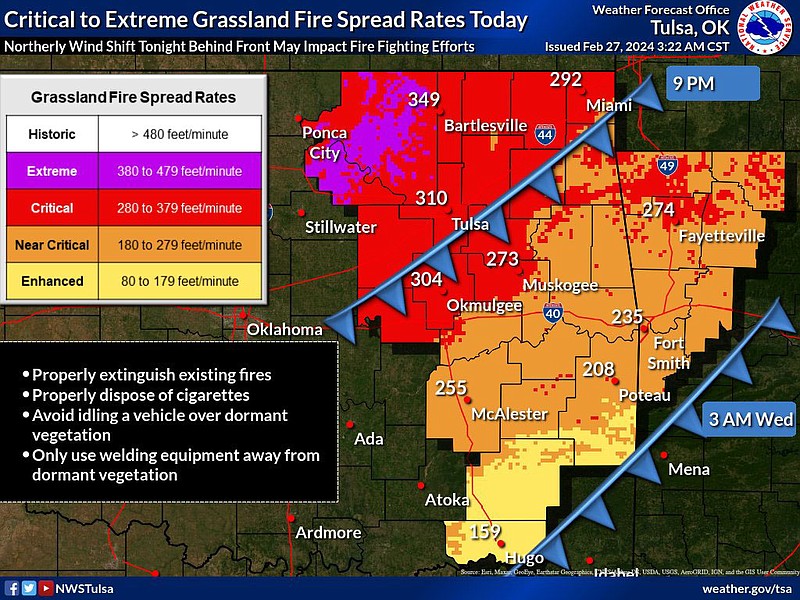
Southwest winds of 10 to 20 miles per hour with gusts to around 25 miles per hour are expected across eastern Oklahoma and western Arkansas Monday afternoon. These winds will combine with record heat, dry vegetation and relative humidity values of 20 to 35% to produce an elevated fire weather danger this afternoon. Enhanced to near critical grassland fire spread rates are forecast for this afternoon.
Record high temperatures are again forecast for Tuesday with an increase in the southwesterly winds in advance of a cold front that is expected to move through the area Tuesday night. Near critical to critical grassland fire spread rates are forecast for Tuesday afternoon across much of northeast Oklahoma and Northwest Arkansas.
Widely scattered showers and storms are possible Tuesday evening across far northeast Oklahoma and western Arkansas as a cold front moves through the area. Noticeably colder temperatures are forecast for Wednesday in the wake of the cold front on the heels of a northerly wind.
Temperatures warm back above normal late in the week and through the weekend as southerly winds return. The potential for storms increases late in the weekend as the next storm system approaches.
Source: National Weather Service