BLANCHARD SPRINGS -- On one of the first sunny days after weeks of winter rain, a pair of geologists decided it was time to look for a fault in the Ozarks.
In the back of a Jeep, Richard Hutto and Angela Chandler packed their tool belts, which held rock hammers, compasses, graphing notebooks and pens.
The Arkansas Geological Survey geologists headed out on another trip into the woods, like ones taken on dozens of other days every year, veering off public trails to scout rock formations and log their latitudes and longitudes to later place on state maps.
The two hike for a living, but have different ideas on hiking for fun.
"I can't do it anymore," Hutto said.
"If I could, I would live in the woods," said Chandler, geology supervisor for the survey.
Chandler grew up in a remote area in Newton County called Limestone Valley. She played with rocks as a child, so geology made sense as a career.
Chandler used to regularly do what Hutto does.
About four days a week for months out of the year, Hutto drives a couple of hours from his Little Rock home with a fellow geologist to discover the terrain of Arkansas. He doesn't like spending that much time away from home, but it's a career for a geologist, he says.
They map where different geologic formations are found. They can tell, through the mapping, where structures shouldn't be built because they could cause landslides. They can tell companies where to drill to access the most gas or oil, although a lot of those companies have moved out of Arkansas. They also can tell where other valuable resources are, such as sand and gravel, commodities used in construction work.
Sometimes they meet interesting people along the way, like the teenager who hopped in Chandler's car and insisted on accompanying them, or the man who claimed to have the fifth-oldest Dodge brothers car and that it had once been driven by Pancho Villa. People always want to take them back to their homes to see their rocks, Chandler said.
The geologists' mapping work is part of a mostly nationwide project to chart the geology of the country, providing information for landowners on the composition of their property and on the risks certain activities may pose.
The survey gets between $110,000 and $210,000 from state and federal sources each year to map the geology of various "quadrangles" in Arkansas -- rectangular areas that geologists split into miniature rectangles. The rectangles are then scoured, typically four days a week for several weeks. It's called the STATEMAP program, and Arkansas has completed 76 maps for it since it started in 1995.
The survey, which also monitors seismic activity and carries out other duties, usually has a state budget of just less than $2.5 million.
On the recent March day, Hutto and Chandler were looking for an abnormal pattern of geological formations that might indicate a fault, one of only a few in the Ozarks.
Hutto thought he spotted it some time ago when he was camping with his family. He went off the Sylamore hiking trail and saw the Everton formation on top of St. Peter sandstone formation, which it usually isn't.
Hutto's not exactly sure what finding a fault would mean for the area. Faults can signify risk for earthquakes, or they can tell prospective drillers where the underground geology may shift, Chandler and Hutto said, but the Ozarks don't have any drilling.
"A lot of it is getting information for information's sake," Hutto said.
Some engineers won't build on faults -- in California it's mostly illegal -- but Hutto doesn't think this fault, if it exists, has had an earthquake in centuries.
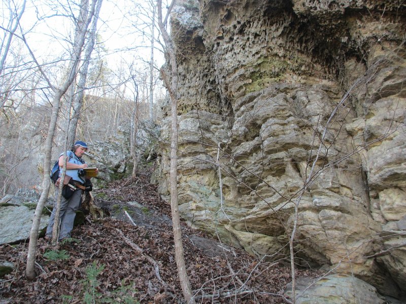
Chandler and Hutto detect rock types using their eyes; they can spot slight differences from several yards away. They also break off pieces of rock using their hammers and drop diluted hydrochloric acid on them.
The way the acid reacts to a rock -- how much the surface fizzes -- can suggest what type of rock it might be.
In March, Chandler and Hutto were looking for Everton formation and St. Peter sandstone formation. The acid fizzes more on St. Peter sandstone.
St. Peter sandstone is found in northern Arkansas and at least 11 other central U.S. states, according to the Arkansas Geological Survey. It's white sandstone, but often darkened by weathering. It's stressed and slightly more resistant than other sandstones. Arkansans would recognize it on Ozarks bluffs above water bodies, such as the Buffalo River, hanging out on top of an Everton formation.
The Everton formation is less known and doesn't exist in as many places. Geologists know it's found in Arkansas and Missouri, according to the Arkansas Geological Survey. Everton's Wikipedia entry is only 18 words -- one sentence. The entry says it's also found in Illinois but provides no source to support that information.
Everton consistently sits below St. Peter sandstone, but Hutto thought he saw it on top of St. Peter, which would indicate a fault, a disruption in the ground.
Chandler and Hutto scaled several hills for five hours in their journey to find the spot where Everton meets St. Peter above it.
Brown leaves crunched beneath their boots, and they stopped to take measurements of the location of the different formations and measure the angles of the formations pointing up or down. The "strike and dip" of the rocks can suggest a fault nearby.
After hours of climbing hills, Hutto and Chandler had spotted St. Peter sandstone with Everton below it and Everton above it. Would the pattern repeat even higher up, Hutto wondered.
"This is it," he shouted, pointing toward more St. Peter sandstone, sitting again on top of Everton. The geology kept switching.
As the daylight waned, they eventually headed down, hoping to find an easy spot to walk back to their vehicle. Chandler saw a several-foot-wide stretch of Sylamore Creek that was only a few inches deep. They could walk on relatively flat terrain on that side of the creek before crossing back over closer to where they parked.
But Hutto didn't want to get his shoes wet, so they decided to traverse the cliffs of the other side. They walked along cliff edges, some so narrow that only one person could fit, all still slick and muddy from weeks of rain.
Then Hutto climbed up something Chandler thought was too steep for her short body to scale. Chandler walked back the way she had come, toward the water. Hutto didn't follow at first, but eventually trailed Chandler back on the soft dirt of the cliff's edge, toward the creek, where they crossed in knee-deep water.
They had found evidence of a fault, because they saw interchanging Everton and St. Peter, but not the fault itself.
They gathered enough information for Chandler to update the geological maps for the Blanchard Springs area.
They'll try to return and continue looking, but they're not sure when.
NW News on 04/09/2018