Favorite hikes in the Ozarks include treks to scenic overlooks with stunning views high above the forest where hawks, eagles and vultures sometimes soar below explorers, not above.
Three overlooks can be reached with short walks that are easy to moderate in difficulty. No need to be a long-distance backpacker to visit Kings River Overlook, Yellow Rock Trail or Hawksbill Crag. All three hikes are a short drive from most of Northwest Arkansas.
Easy does it
Short, easy hikes that are long on beauty can be enjoyed around the region. Here’s a sample:
• Lost Valley: This hike near the Buffalo National River close to Ponca is 1.1 miles out and 1.1 miles back. Features include waterfalls, a large bluff shelter, rock outcrops and forest scenery.
• Tanyard Creek Nature Trail: The two-mile loop trail in Bella Vista packs a microcosm of the Ozarks into a pleasant hike. The hike visits a spring, Ozark stream, bluffs and forest. Walls of icicles occasionally form when it’s cold. Interpretive signs identify trees and wildflowers. The trailhead and parking area is one mile west of U.S. 71 on Lancashire Boulevard.
• Shaddox Hollow Trail: This 1.5-mile loop at Hobbs State Park-Conservation Areas is one of the park’s most scenic paths. Hikers pass rock outcrops, a stream and bluff shelters. A side trail leads to Beaver Lake. The trailhead and parking are one mile north of the intersection of Arkansas 12 and Arkansas 303 east of Rogers.
— Staff report
Here's a look at each hike, with driving directions and what's to see along the trail. Pack a picnic lunch in a day pack for fine dining at some of the most gorgeous views the region has to offer.
Kings River
This is the easiest of the three hikes. The trail is a level one-half mile path from the parking area to the overlook. Kings River Overlook towers above the river in the McIlroy Madison County Wildlife Management Area, which takes in 14,000 acres of rough, steep terrain.
Start at the information kiosk in the parking area and head into the cedar and hardwood forest on the wide path. There are three little creek crossings, just seeps, actually, that are small enough to hop over. In no time hikers are standing on the edge of the overlook.
The river shimmers below the sheer cliff face. The soothing sound of rushing water can be heard when the river is running fast and full.
Directions: Arkansas 23 north from Huntsville for about 12 miles or south from Eureka Springs about 18 miles. Turn east on the gravel road at the entrance sign for McIlroy Madison County Wildlife Management Area.
Follow gravel roads five miles to the parking area. The route is well marked with signs directing travelers to Kings River Overlook.
Yellow Rock
The trail at Devil's Den State Park leads to wide wilderness vistas above Lee Creek, which bisects thispopular state park. The whole trail is three miles, but the overlook is one mile from the trailhead near Campground A.
On the way to the overlook, hikers visit boulders large as buildings and see a bluff shelter. There is a small cave that goes back a few feet that is a favorite for youngsters to explore.
The route to the overlook is gradual uphill of easy to moderate hiking. Take a fully charged camera to capture the breathtaking scenes from the precipice. There is lots of room to roam around.
Directions: Devil's Den State Park is 18 miles south of West Fork on Arkansas 170 or eight miles west of Winslow on Arkansas 74. Yellow Rock Trail parking and trailhead is near Campground A.
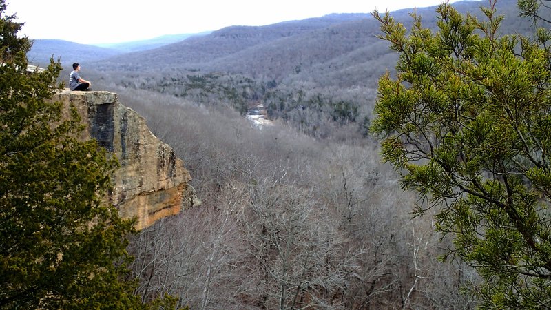
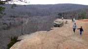
A 360-degree image from Flip's hike at Hawksbill Crag
Full Size Flip PutthoffHawksbill Crag
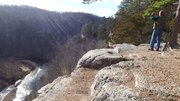
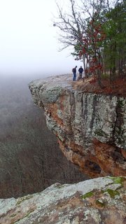
This may be the most photographed landmark in Arkansas and with good reason. The rock outcrop in the Upper Buffalo Wilderness looks like a hawk's bill or a turtle's head. Views from the crag are long, gorgeous and inspiring.
Equally welcome is the silence. There is no distant traffic noise, no machinery, only the occasional sound of breeze in the trees.
The 1.5-mile trail is mostly downhill to the crag. Not far into the hike the trail follows a stream and leads to a waterfall during wet times. Hikers can scramble down to the base of the waterfall or follow the trail out to Hawksbill Crag.
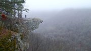
A recent visit was a special treat because it occurred on a foggy morning. Worries were that nothing could be seen through the thick fog, but the mist and gray offered unique views on the Edgar Allan Poe kind of day.
Directions: From Kingston in Madison County, follow Arkansas 21 south through Boxley Valley to the Buffalo National River. Just before crossing the river, turn right on the gravel road, which is Cave Mountain Road. Travel 6.1 miles to the parking area and trail head. Some of the route is steep and rough.
Flip Putthoff can be reached at [email protected] or on Twitter @NWAFlip.
Sports on 02/07/2017