FAYETTEVILLE — Pastor Dan Wooley has watched the confusion as drivers try to meander their way from one offset portion of Rupple Road to the other through Mount Comfort Road, which compounds during rush-hour traffic.
On the agenda
The City Council will consider two measures associated with the Rupple Road improvement project during its meeting at 5:30 p.m. Tuesday in Room 219 at City Hall, 113 W. Mountain St.:
• A resolution to approve a supplemental agreement with Garver, designers of the Rupple Road project, for $307,167 to cover construction management costs, additional archaeological testing and mitigation and additional design services.
• A resolution to award a $5,574,726 contract with Cross-land Heavy Contractors to build a portion of Rupple Road from West Starry Night View to Mount Comfort Road, and approve a project contingency of $418,104.
Source: Staff report
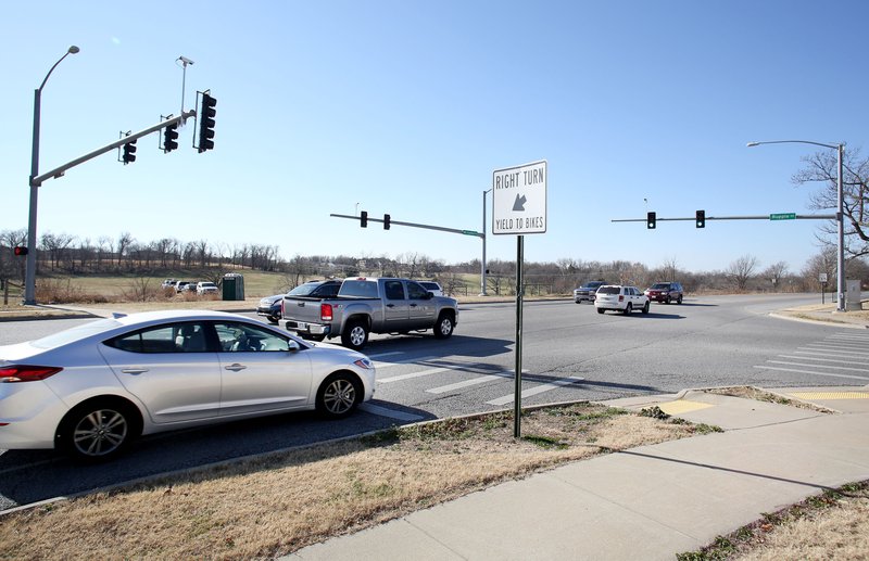
His Presbyterian church sits right at “ground zero” of the intersection. It’s not particularly dangerous — 35 accidents happened there from 2011 to 2015, with police receiving 10 calls since. But Wooley welcomes any improvements that would help with traffic flow and maybe make it easier to get out of the church’s parking lot.
“It’s pretty busy there,” he said. “Unless it’s somebody who drives it all the time, it’s a little bit tricky.”
The City Council on Tuesday will consider a nearly $5.6 million contract with Crossland to overhaul the intersection. Design started in 2014 with archaeological excavations. Land acquisitions and an attempted rezoning followed.
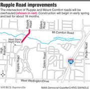
The section from Starry Night View to Mount Comfort Road, about 1,700 feet, serves as Phase III of the larger Rupple Road project. The first phase extending Rupple from Persimmon Street south to Martin Luther King Jr. Boulevard wrapped in October 2016. The second phase to widen the road from there, near the Boys and Girls Club, to Wedington Drive, basically has finished with some striping left to go.
The first phase cost nearly $8.8 million. The second had a price tag of about $2.8 million. City Engineer Chris Brown estimated the third and final phase should end up at close to $7.5 million.
All told, Rupple Road will receive more than $19 million worth of work. Payment has mostly come from federal dollars and the $65 million bond issue city voters approved in 2006.
The Rupple Road improvements are a major part of a larger effort to complete the “Mayor’s Box” around the city. The 20-mile arterial loop will serve as a way to move easily from one end of the city to the other.
Joyce Boulevard and Crossover Road make up the northeast corner. Crossover to Huntsville Road, 15th Street and Martin Luther King Jr. Boulevard make up the southeast portion. Martin Luther King Jr. Boulevard and Rupple Road form the southwest corner. Rupple and Howard Nickell roads to Arkansas 112 will finish off the northwest edge.
It’s a project Mayor Lioneld Jordan has dreamed about since he served on the City Council in 2001.
“It’s going to be a great accomplishment for the city,” he said. “You work on something like that and one day you wake up and it’s there.”
DIGGING DEEP
The newest leg of the project involves aligning Rupple Road to cross through Mount Comfort in a perpendicular manner, rather than offset like it is now. The road will be widened to four lanes from near Starry Night View to the intersection. The contract includes a new four-lane bridge that crews will build on site.
Additionally, a sidewalk will go on the east side of the road with a 12-foot-wide trail on the west side. The intersection also will have signals for all four directions of traffic.
A supplemental agreement, also on the council’s Tuesday agenda as a separate item, adds $307,000 to the bill for the intersection project. The extra cost is associated with design work, archaeological testing and excavation.
The city was required to have an archaeological survey done because it received federal money for the project. Investigators found chips that appeared to be leftovers from stone tool making, Brown said, requiring deeper excavation.
The mitigation process, essentially digging for any culturally significant artifacts or pieces, delayed the project by about a year. The layout of the road had to be moved slightly to avoid archaeological sites, which can be small pockets containing possibly significant remnants, said Mark Christ with the Arkansas Historic Preservation Program.
“We try to do what we can to protect the resources without stopping projects dead in their tracks,” he said.
The area the project impacts has deeply buried cultural deposits and potential to contribute to the knowledge and understanding of people who lived in Arkansas thousands of years ago.
VISION OF THE FUTURE
The council rejected a rezoning proposal last December from Jim and Judith Hazen, the owners of several acres just south of the intersection. The measure would have rezoned about 70 acres from agricultural or single-family zoning to a mixed-development community services district. That type of zoning allows a wide variety of uses, from homes to restaurants, gas stations and offices.
The council split 3-3 and the measure failed. Several residents spoke about the proposal in the Planning Commission and council meetings leading up to the decision, some for it but many against. Those concerned about the potential development said the road and intersection couldn’t bear any more traffic, exacerbating an already troublesome situation.
It’s fairly common for the city to seek a rezoning measure associated with a major road project, Planning Director Andrew Garner said. About 600 acres along or near the first phase of the Rupple Road project were rezoned in anticipation of new development, Garner used as an example.
That idea especially rings true when the area in question has a lot of open space, like the Hazen’s property, Garner said.
“If city’s investing a lot of money in projects it makes sense that the zoning lines up with the vision of the future,” he said.
The 1-year threshold to resubmit a rezoning proposal is coming up soon on the property. Justin Jorgensen, of Jorgensen and Associates, said he hadn’t heard from the Hazens recently about putting together a new request.
The city still has a gap to fill in Rupple Road, from West Tanyard Drive to Weir Road. Jordan said funding for that will have to come from renewal of the bond issue, which the administration hopes to have ready to present to voters by 2019.
Stacy Ryburn can be reached by email at [email protected] or on Twitter @stacyryburn.