Forecasters increased their estimates Tuesday on the amount of rainfall expected in Arkansas over the remainder of the week from a slow-moving weather system.
The system entered the state Tuesday from the southwest, at one point dropping 2 inches of rain in three hours in the Texarkana area, according to reports.
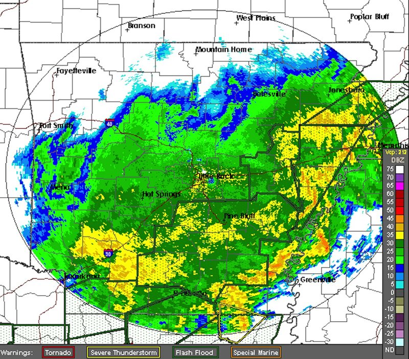
The National Weather Service said an area stretching from Texarkana to Mountain Home could receive more than 7 inches of rain in waves through early Friday. Little Rock is expected to see 5-7 inches. Northwest Arkansas could get 4-5 inches, northeast Arkansas could get 3-5 inches and the eastern Delta will receive more than an inch.
Some areas in southwest Arkansas could get up to 10 inches of rain, said National Weather Service meteorologist Mario Valverde of Shreveport.
"It'll rain, rain, rain," he said. "Some places will get a lot of rain, since this is so widespread."
Forecasters also have increased their predictions for river levels across much of the state after receiving updated models of the weather system, said National Weather Service hydrologist Tabitha Clarke of North Little Rock.
"We're looking at a potential for 6 to 8 inches of rain in the next 48 hours," Clarke said. "It's going to push the rivers up more. It's going to kick up, and we'll see some good downpours all day [today].
"No one is really going to dodge this one."
The system, which produced heavy rain Sunday in California, crept across the southern United States below the jet stream -- a rapidly moving band of air that generally moves weather systems through quickly. Because it is out of the jet stream's influence, this weather system will move slowly and "wobble," or waver back and forth, Valverde said.
The weather system is not expected to "train," or create small thunderstorm cells that rain repeatedly on the same areas, he said. Major flash flooding, like the kind that killed five people in Scott County in May 2013 or 20 campers at the Albert Pike campgrounds in the Ouachita National Forest in June 2010, is more apt to occur during "training" of storms, Valverde said.
Although the system could create some thunderstorms, forecasters do not expect any tornadic weather in Arkansas.
Rain began falling in Camden on Tuesday afternoon about four hours later than initially expected.
County Judge Robert McAdoo left the Ouachita County Courthouse at noon Tuesday to get his raincoat from his truck.
He said he was concerned that roads damaged by December flooding could worsen from the bands of rain expected from this weather system, and he urged motorists to use caution.
"We haven't even gotten our FEMA money yet for the last one," McAdoo said, referring to Federal Emergency Management Agency funds to help rebuild roads and bridges that were damaged in his county late last year and early this year.
County crews began filling sandbags Tuesday morning in preparation for flooding and have more sand available if needed, McAdoo said.
The Ouachita River at Camden is expected to reach 32.4 feet by Sunday morning. Flood stage there is 26 feet. On Jan. 2, the river reached 35.5 feet.
"If it stays under 33 feet, we'll be fine," McAdoo said. "If it gets to 36 to 40 feet, we'll have problems."
Organizers of the 23rd annual Camden Daffodil Festival watched weather reports but said they were not planning to cancel the festival.
"We've not had a festival canceled in 22 years," said Katie Parrish, the event's president. "We've held it through rain, sleet and snow. We'll keep on going as planned."
Only one of the 200 vendors who registered for the event canceled because of weather, she said.
"There must be something about the second week of March that invites bad weather," Parrish said.
The Saline River at Benton is expected to climb to 22 feet by noon Thursday. Flood stage is 18 feet. The river reached 20.9 feet on Dec. 28.
In Hot Springs, where rain runoff can cascade down from the hills, Garland County's Office of Emergency Management director, Bo Robertson, said his priority was warning motorists not to drive through flooded areas.
Sixty percent of those who drown die in cars, he said.
"Don't try to cross washed-out roads," he said.
He said some county roads remain damaged from earlier storms' flooding. Rather than repair the roads only to have them wash out again, crews are working on mitigation projects.
"We may increase bridge sizes when we replace them, and we can use riprap concrete to strengthen culverts," Robertson said. "You can't control the runoff. You have to deal with it."
U.S. Army Corps of Engineers officials monitored water levels in reservoirs in and near the state.
Engineers began releasing water from dams on Beaver, Table Rock, Bull Shoals, Norfork, Greers Ferry and Clearwater lakes in anticipation of the rainfall, said Laurie Driver, a Corps spokesman.
"We were lucky to get to the conservation pool level so quickly," she said. "Since the December floods, we've had two months of dry weather."
The National Weather Service said that since January, much of the state has received at least 4 inches below average rainfall.
"We ended the winter below average for rainfall, which is good for this coming rain," Clarke said. "The first round of rain should be OK, but the second and third rounds will be tougher to handle," she said of the bands of rain expected this week.
The weather system is expected to move out of the state by Friday, but "wrap around" moisture that follows the main system could produce some rain across the state Saturday, Clarke said.
A Section on 03/09/2016