As the Arkansas River neared its crest Wednesday at several points in central Arkansas, high water from the swollen Red River in south Arkansas held steady.
In Little River County, which is sandwiched between the Red River and Little River, Mike Cranford -- county judge of Little River County -- summed up the flooding in one word: "Terrible."
"Devastating is not even a reasonable word. It doesn't even come close to describing it," Cranford said.
The Red River at Index was measured Wednesday evening at 31.47 feet, well above the flood stage of 25 feet. Close by at Fulton, where the flood stage is 27 feet, floodwaters lingered at 31.55 feet, according to the National Weather Service.
Eighty percent to 90 percent of the Red River basin in Little River County is covered in water, Cranford said. And the land that's not inundated can't be reached because roads are closed.
"Most people who lived through the '90s flood took measures to move animals and equipment, but you can't move everything," Cranford said. "Your house is still there. Buildings are still there."
Cranford estimated that dozens of families and tens of thousands of cattle have been displaced as farmers look for places to move equipment away from the water.
Gov. Asa Hutchinson has deemed 31 counties in Arkansas as disaster areas from the flooding and heavy rains that came beforehand, making state funding available for emergency measures now and cleanup or repairs later.
The economic effect of the flood likely will reach millions of dollars, Cranford said. Thousands of acres of planted crops are underwater; portions of U.S. 71 and Arkansas 41 are closed, so travelers won't be stopping to buy things as they head to vacation destinations; and popular fishing lakes are shut down over safety concerns.
"It's a tremendous amount of devastation," Cranford said. "Any way you look."
Wild animals have moved along with the floodwaters. Cranford said county officials have been getting calls about alligators in ditches and yards, plus snakes and other varmints.
In Jefferson County, Paula Oliger, a resident of Wright and volunteer firefighter, said the number of snakes in the area now heading toward dry land is "unbelievable."
"The ramifications are far reaching," Cranford said. "Far more than the average person could fathom."
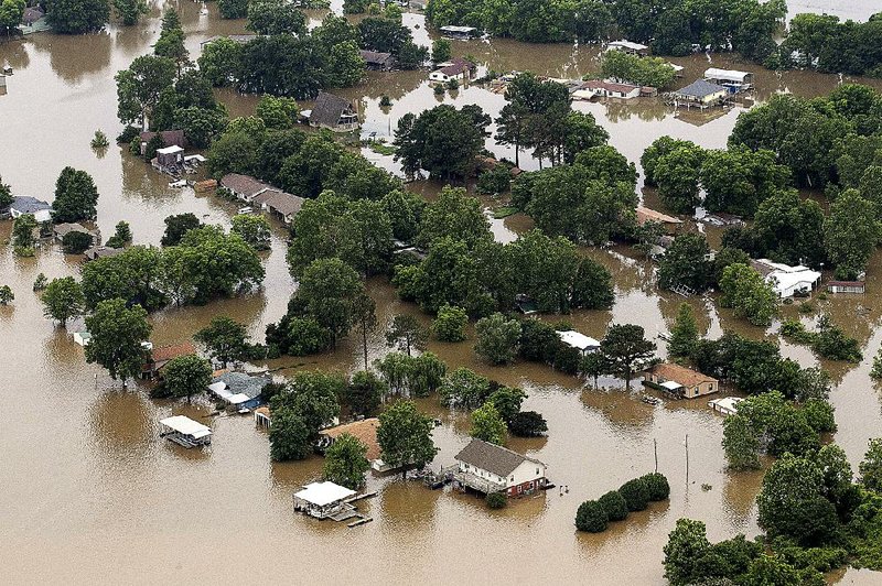
In Mayflower, the National Weather Service said nearby Toad Suck Lock and Dam was experiencing "major" flooding of the Arkansas River just under the projected crest Wednesday night of 280.5 feet.
Many of the homes along Mayflower's Jones Lane are built high off the ground. After the 1990 flood -- which established the ground by which this flood is being gauged there -- regulations forced new homes there to be constructed that way.
Mayflower Fire Chief Carl Rossini said the Fire Department, the Faulkner County Office of Emergency Management and others in the community are checking on about 100 stranded people every day.
"These people have gone through this enough," Rossini said. "They know what they need to do."
The flooding in Mayflower comes on the heels of the 2013 Exxon Mobil oil spill there and a devastating 2014 tornado.
"Kind of a dark cloud hanging over us, but we always come out with a silver lining," Rossini said.
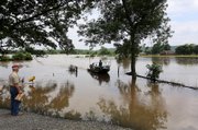
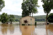
Bob Magee and his wife, Jo Magee, are stranded at their house on Jones Lane. It is surrounded by water, but none has reached the home, which sits on a slight hill.
Bob Magee's T-shirt reads: "Life is good."
"Welcome to paradise," he yells to the people approaching on a boat.
"It's a little bit inconvenient because we can't leave," he said.
Magee has passed the time by weeding his garden, painting Adirondack chairs and enrolling in Medicare after turning 65, but his list of chores is growing short. And the inconvenience of high water might continue for at least two weeks before the Magees can leave their house.
Bob Magee, who's retired, is quick to point out that they are incredibly lucky.
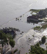
Other neighbors on Jones Lane have not fared as well. Only the roof of a nearby store is visible.
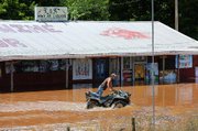
Some people's homes have been spared but they must spend up to 45 minutes a day boating in and out of the neighborhood to get to work. In doing so, they dodge the tops of fences, mailboxes, doghouses and giant bales to cross land that is normally fields of beans, rice and hay.
In the Little Rock area, where hydrologists from the National Weather Service expected the Arkansas River to crest at its flood stage of 23 feet Wednesday night, flooding was deemed "minor."
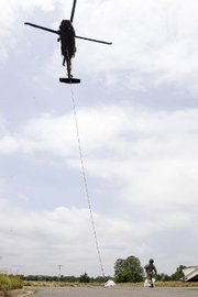
However, members of the Arkansas National Guard's 77th Theater Aviation Brigade performed an "emergency sling-load operation" Wednesday morning at Murray Hydroelectric Plant, using a UH-60 Black Hawk helicopter to help seal a 4-inch pipe holding communications cables providing a pathway for floodwaters to get into the plant.
Officials from North Little Rock, which gets some of its electricity from the plant at Cook's Landing, placed the call for help. The mission involved configuring five 4,000-pound sandbags into place, a National Guard news release said.
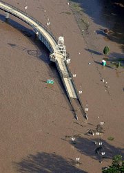
Flanking Interstate 430, which crosses the Arkansas River, parts of both the Big Dam Bridge and Two Rivers Park bridge were under water.
Farther south in Jefferson County -- where the Arkansas River was expected to crest at 46 feet overnight, 4 feet above the flood stage of 42 feet -- some residents had left their homes in search of a dry place to stay.
Arkansas Department of Emergency Management spokesman Rick Fahr said Wednesday afternoon that at least 19 people were staying in shelters. Four people are at the Wright-Pastoria Volunteer Fire Department in Wright, and 15 people are at the Swan Lake Fire Station in Altheimer.
"Fortunately some of the worst flooding isn't in heavily populated areas," Fahr said.
Metro on 06/04/2015