Rogers, Arkansas, 1896, was a very different place than the city today.
The population was just 2,200 (according to a Sanborn map; or 1,900, according to the census). The town's sprawl remained contained in the area of today's downtown commercial historic district. But, just like today, people wanted to protect their investments. The Sanborn Fire Map Co. helped.
FAQ
‘The Amazing Sanborn
Fire Maps’
WHEN — 2 p.m. Saturday
WHERE — Hobbs State Park, 20201 E. Arkansas 12 near Rogers
COST — Free
INFO — 789-5000
"The Sanborn maps were originally created for assessing fire insurance liability in urbanized areas of the United States," says information provided by Robert Rousey of the Rogers Historical Museum.
Hobbs State Park presents Rousey speaking about the maps during a program at 2 p.m. Saturday. He will have an 1896 map, borrowed from University of Arkansas Special Collections, for viewing. The first map of Rogers was published in May 1896, Rousey says.
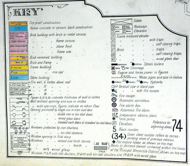
The maps were published in bound volumes, and each map in the volume usually depicted four to six blocks. Included in the book were an address index; an index of "specials" -- churches, schools, businesses, etc.; and general information such as population, economy and prevailing wind direction. The volumes were updated from time to time, but the maps more frequently. A new map simply was pasted over the old one.
Each map includes outlines of each building and outbuilding in its area; the location of windows and doors; street names; street and sidewalk widths; property boundaries; fire walls; natural features, such as rivers and canals; railroad corridors; building use (sometimes, particular room use); house and block numbers; composition of the building materials, including framing, flooring and roofing materials; the strength of the local fire department; sprinkler systems; locations of fire hydrants; location of water and gas mains; and the names of most public buildings.
The maps were color coded by construction type.
"The colors were something you could look at real quick and decide," Rousey says.
In his presentation, Rousey will include maps showing the Hawkins House -- an 1895 five-room brick home, now part of the museum -- and the intersections of Elm and First streets and Poplar and First, where buildings shown on the 1896 map remain, he says.
He also plans to point out several livery stables on the maps. Because of all the flammable materials in and around a stable, the liveries and adjoining buildings presented increased fire risk and probably higher insurance premiums.
"The maps were utilized by insurance companies to determine the liability of a particular building through all the information included on the map: building material, proximity to other buildings and fire departments, the locations of gas mains, etc.," reads information provided by Rousey. "The very decision as to how much -- if any -- insurance was to be offered to a customer was often determined solely through the use of a Sanborn map."
The Sanborn company, founded by Daniel Alfred Sanborn, a surveyor from Somerville, Mass., began making maps in 1867. Mapping for insurance purposes began in the 18th century in London. Today, the Sanborn maps can be found in the archives and special collections of many cities, libraries and universities. They remain as a resource for historians, genealogists, planners and demographers.
"I just love those Sanborn maps," says Steve Chyrchel, an interpreter at Hobbs State Park. "I got into them when I lived in Eureka Springs. There were lots of maps of Eureka Springs. They had four major fires in the 1880s. The entire downtown area burned down, and they had to redraw the maps."
NAN What's Up on 03/21/2014