BENTONVILLE - Mountain biking at Bentonville and Bella Vista is something special. Evidence?
There’s a hill in the Slaughter Pen Hollow Mountain Bike Trail System named the “Presidential Bush Push.” Former President George W. Bush biked the Bentonville trails in November 2010 and afterward declared them among the best he’d ever ridden.
Members of the International Mountain Bike Association, who visited the area scouting locations for IMBA’s 2014 World Summit, referred to the Blowing Springs Trails at Bella Vista as the pinnacle of single-tracks, demonstrating sustainability in trail design and construction.
A visit with these trails’ creator, Nathan “Woody” Woodruff, owner of Progressive Trail Design, leaves you feeling less surprise at such accolades. Before a shovelful of dirt was turned or a rock was moved, Woodruff first decided what type of path was needed to contribute to the overall experience of offroad riding in the region. He then designed and built trails to achieve those goals.
Bentonville’s mountain biking options include the three phases of Slaughter Pen, Park Springs Park and All American Trail - five separate sections within the same area, each a short ride from the other. Blowing Springs is in Bella Vista, which is a short ride from the Slaughter Pen area via paved bike path.
Also, Progressive Trail Design is building a Slaughter Pen and Blowing Springs connector trail.
All these trails are so close together that riders think of them as the Bentonville/Bella Vista Trail System. (And this doesn’t even include the area’s growing shared-use paved trails and the network of trails around Crystal Bridges Museum of American Art, where Crystal Bridges Trail, Art Trail and Orchard Trail are appropriate for biking.)
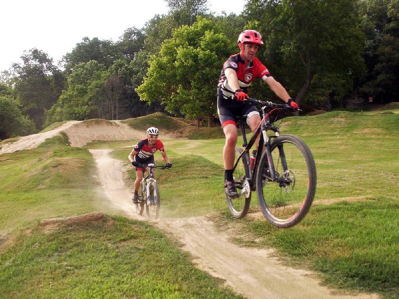
Since the first five miles in Phase One of the Slaughter Pen construction project were completed in 2007, mountain bicyclists from four states have made a habit of visiting the trails in Bentonville and Bella Vista. But even with well marked maps at each trailhead, some sections get very little use. Experienced riders would say that anyone who bypasses these routes is depriving himself of some truly enjoyable mountain biking, but enjoyment has something to do with a rider’s skill. Still, by skipping certain sections, riders don’t getto appreciate Woodruff’s overall master plan.
Each section of trail was constructed for a specific purpose, such as providing a training ground for improving certain skills, or offering a playground on which to put those skills to good use. In the interest of providing riders with the most fulfilling off-road biking experience, and with Woodruff as our guide, this article provides a tour of the Bentonville/Bella Vista Trail System, describing the intended goal and purpose of each section.
PARK THE CAR
There are adjacent parking areas conveniently located throughout the trail system, such as at Compton Gardens in downtown Bentonville and at Blowing Springs Park, at schools near the trails and in the main parking area on North Walton Boulevard. This is where our tour will begin.
Leaving the parking area, ride the paved bike path half a mile to the entrance to Phase I of Slaughter Pen. Don West, author of Mountain Biking Northern Arkansas and owner of Chainring Adventures, was responsible for the design and construction here. With the initial 5 miles of single-track snaking through wooded hollows and over rolling hills, West’s goal was to create trails for beginner and intermediate level offroad cyclists and also to show area officials there was public interest in an off-road system.
To appeal to the more advanced rider, ladder bridges, elevated log rides and other man-made technical elements appear throughout the section; but the trails still offer a natural, flowing bypass route around these obstacles for the less adventurous cyclist.
FREE RIDE PARK
Woodruff ’s influence is present in Phase I with the world-class Free Ride Park. With its gravity-fed downhill flow, high-banked bermed turns, dirt roller-overs and many jumps, the trail was intended as training ground to hone advanced bike-handling skills.
Unlike cross-country trail riding, where it is difficult to return to a particular location for a do-over, in this park you can redo a jump or high-bank turn by just whipping your bike around. You can do repeats until you have perfected the move.
If you are into screaming descents with 10-foot banked turns and a giant tabletop jump, you will want to ride Downhill Flow, a feature at the north end of the Phase I section. This run, added during a later phase, was designed to peg out your “fun factor” meter.
ENTER PHASE II
Phase II was Progressive Trail Design’s first trail construction contract. To reach Phase II West, turn right on Seed Tick Shuffle after entering the gate to Phase I. Follow this trail to the base of Free Ride Park, then exit through the gate and cross the paved trail to the Phase II entrance.
These trails provide more flowing cross-country miles - but the technical skill requirements have been raised a notch or two. The trails are a little rockier and the climbs are somewhat steeper than in Phase I; this is in line with Woodruff’s master plan for progressively challenging trails.
Shortly after beginning your ride on Urban Trail in Phase II West, you’ll pass the Bush Push, a double-track trail that climbs straight up the hillside. Stop to read the sign commemorating Bush’s nonstop ride on Nov. 22, 2010.
There are several exit options for Urban Trail, with turnoffs for two more switchback trails snaking up the hillside that will push your skills further. Or you can cross North East A Street to reach the entrance for Phase II East.
The east section has more than a mile of cross-country bike trails similar to those on the western section. Similar does not mean identical, though. Each trail has its own personality and challenges.
THE PLAYPEN
To reach Phase III, after crossing the wooden bridge when exiting Urban Trail, turn right to parallel, then join the paved path for a half mile. As the paved path curves left to go under the road, the entrance is straight ahead.
Local riders fondly refer to this section of difficult trails as “The Playpen.” Working in collaboration with IMBA, Progressive Trail Design packed 10 trails onto a small hillside, resulting in quicker elevation gains and losses than in any other section.
Begin riding Rocking Horse, then select one of the intersecting trails to ascend the side of the hill and reach the entrance of Boo Boo. This is a one-way trail, so you don’t have to worry about any close encounters of the head-on kind, which is great, because with numerous tight-knit, 10-foot bermed turns, riders do not have time to look beyond the next turn.
Using the skills refined at Free Ride Park, see how high you can leave your tracks in the steep turns. Ride all the trails in Phase III, and then ride them again and again, because it’s playtime.
SEE CRYSTAL BRIDGES
Return to the Phase III entrance gate and then turn right to follow the paved path under the road. Then ride along a bluff overlooking Crystal Bridges Museum of American Art to reach the All American Trail. This trail was another IMBA and Progressive Trail Design collaboration. It was designed not only as a gateway to Slaughter Pen from downtown Bentonville, but also as a gateway to the sport of mountain biking. With the half-mile trail paralleling the paved path, it is a great ride for kids - with parental supervision.
In this short stretch, beginners can work on basic bike-handling skills by riding boulder causeways, log rides, stone armored rollers and a fun one-way downhill flow track.
TWO PARK TRAILS
To reach the Park Springs Park trails, return to the entrance of Phase III and continue to backtrack on the paved path to the crossing for North East Cub Circle. Turn left to reach Tiger Boulevard, and then left once again. It is about a half mile to the park.
Across the intersection of Tiger Boulevard and North West A Street, to your right, is the entrance to the Lincoln Park trails. To the left is the entrance to Park Springs Park. Both trail systems are commonly lumped together as Park Springs Park trails; however, like an overlooked stepchild, Lincoln Park has plenty of personality for those who take the time to get to know it.
Lincoln Park Trail is one mile of fast and “flowy” single-track, littered with fun dirt berms and rollers that give it a pump-track feel. For a little added tension, Woodruff built a 400-foot ladder bridge that weaves through the trees to test a rider’s balance and handling skills.
Park Springs Park has wide, well-groomed trails that gently roll along the hillside before dropping down for several creek crossings on picturesque stone and large timber bridges. With its smooth, crushed gravel surface, this is a great trail for bicycles having little or no suspension.
Preservation was the theme for this trail. The level of care that the construction crew took to maintain this beautiful natural sanctuary is appreciated by bicyclists and hikers alike. Park Springs Park and Lincoln Park Trails have gateway trails to three adjoining schools, making them easily accessible to the neighborhood youths.
HEAD NORTH
The remaining two sections of trail are to the north, and require backtracking to the entrance of Slaughter Pen Phase I. At that point you will turn right to follow the paved path along the crystal clear waters of McKisic Creek. After 1.5 miles, turn right and cross a bridge over Little Sugar Creek.
Once over the bridge, as the path curves left, you will continue straight to the entrance to the Slaughter Pen and Blowing Springs Connector trails. Today there are two trails - lower and upper - that run the length of the bluff. The lower trail includes several man made elements for a heightened fun factor. The upper trail incorporates the natural bedrock of the bluff, to provide alternate lines for cyclists to choose from as they pick their way across the rock ledges.
As you traverse the upper section of trail, pause a moment to admire the craftsmanship of its construction.
BLOWING SPRINGS
Once you have mastered the bluff trails, drop down to the paved path once again to continue right. Turn left on Dartmoor Road to ride past the ballfields and Cooper Elementary School.
When you reach the stop sign for Blowing Springs Road, turn right to enter Blowing Springs Park - this is where the trailhead is. You’ll find a good-size parking lot and a portable toilet.
The park also includes the Bella Vista Village RV Park, for those who want to park a trailer and spend a few days biking with the family.
Woodruff had one goal in mind when designing the Blowing Springs Trails: “Mad flow!” Seven miles of it weave through thickly forested hillsides and across deep valleys. These are the Arkansas Ozarks, so there are hills, but the climbs are less punishing than in many of the other trails in the area.
The descents are also more “flowy,” with fewer tricky, rocky drops. These trails were designed for beginner to intermediate riders; however, the more advanced riders will want to visit them to feed their need for speed.
Bob Robinson is the author of Bicycling Guide to the Mississippi River Trail (spiritscreek.com).
Fast factsBENTONVILLE/BELLA VISTA OFF-ROAD TRAIL SYSTEM
Getting there: For the main parking area in Bentonville, take Exit 93 off U.S. 71, drive one mile on North Walton Boulevard to the lot adjacent to Bark Park dog park.
Total miles of off-road trail: 25 (and growing)
Brief history: Phase I of the Slaughter Pen Hollow Mountain Biking Trail began in the spring of 2007 with land donated to the city by the Walton family through the Bentonville/ Bella Vista Trailblazers - a 501(c)(3) organization.
Using more land donated by the Waltons and designated green space in the communities of Bentonville and Bella Vista, plus added Arkansas Trailblazers funding, the trail system has evolved into seven separate segments of off-road trails. These are Slaughter Pen Phases I, II, III, All-American Trail, Park Springs Park, Slaughter Pen to Blowing Springs connector trail, and Blowing Springs.
Support group: Friends at Slaughter Pen Trail (FAST) supports the development and maintains trails in the area and promotes off-road cycling in Northwest Arkansas.
- Bob Robinson
ActiveStyle, Pages 23 on 07/29/2013