LITTLE ROCK — One surefire recipe for drawing a crowd to the great outdoors of Arkansas starts with access to a beautiful stretch of a mountain stream.
Make it one with clear, green-tinted water rippling through a riffle for playful splashing ... flowing into a cool, deep pool for soaking ... alongside a long, high and wide gravel bar for sunning.
Then top it off with a well developed day-use area of picnic tables and restrooms on both sides of the river.
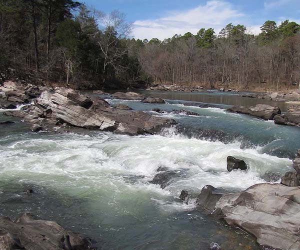
The Brushy Creek Access to the wild and rugged Cossatot River had it all.
Yet on a bright, sunshiny Friday in the spring-break season, the place was completely deserted.
Well, not quite.
As Terry Fredrick and I stood on the gravel bar to absorb the wonderful setting, a river otter came casually cruising downstream, sliding through the rocks of a riffle, dipping through a pool, acting like it owned a place where it was accustomed to peace and quiet.
We had left Fayetteville that morning with the aim of hiking a remote wilderness area in the heart of the Ouachita Mountains and had only minutes earlier left U.S. 71 and turned east on Arkansas 246 at Vandervoort. We had been motoring along when we noticed something that caused us to shortstop our plan at the Cossatot.
The highway bridge across the river appeared relatively new, but the attention grabbers were a new steel pedestrian bridge over the river on the right and a new riverside parking area on the left. We made an immediate U-turn to the parking area to investigate what was to be the beginning of many impressive revelations for the remainder of the day.
Along with a new restroom and nice landscaping, the parking area featured a large sign where maps and brochures let us know we were at the Brushy Creek Access to Cossatot River State Park-Natural Area.
We hadn’t visited the park since the mid-1990s when it consisted mostly of Cossatot Falls, a long, rocky run of cascades regarded as one of the most spectacular river features in the entire state on one of Arkansas’ most technically demanding white-water streams.
Much to our surprise, we learned that in recent years and at great expense, the park had become a “corridor park” extending more than 12 miles along the river from Arkansas 246 at the north end and downstream to U.S. 278 and beyond to a new Visitor Center.
Besides Brushy Creek Access, the corridor along the still rocky and fast-flowing river included other access points at Ed Banks Bridge, Sand Bar Bridge, Cossatot Falls and U.S. 278.
Of particular interest was a brochure map (out of date for hikers but still helpful for drivers) showing the route of the River Trail meandering along the river from Arkansas 246 to U.S. 278 and passing through the accesses in between. It struck us as having the potential of being the Ouachita Mountains’ equivalent of the Ozarks’ Sylamore Creek Trail near Mountain View, which has five accesses and renowned stream side scenery.
The comparison would return in many respects throughout the rest of the day.
ASSESSING THE ACCESSES
After admiring the beauty of Brushy Creek Access, we continued east on Arkansas 246 for about a half-mile to a gravel road on the right marked with a large park sign indicating the distances to the downstream accesses as hikers would reach them using the recently rerouted trail: Ed Banks Bridge, 6.5 miles away, followed by Cossatot Falls, Sand Bar Bridge and the Visitor Center. (As the crow flies, the sand bar comes before the falls.)
With a surface of crushed rock, the well-maintained road provided smooth motoring as it led through the timberlands of the Weyerhaeuser timber company. After that it was just a matter of following the signs at various crossroads to the accesses.
The Ed Banks Access was a pretty spot with fine views upstream and downstream of the rocky, clear-flowing river. It also offered picnic tables, a restroom and a few primitive campsites. The Sand Bar Bridge Access was also a picturesque riverside setting along with picnic tables, restroom and primitive campsites.
So far, however, we had yet to see a single person enjoying the beauty of these sites.
Figuring to save the best for last, we bypassed Cossatot Falls and headed straight for the U.S. 278 Access, stopping only for a quick look at the access and its picnic area and primitive campsites, before crossing the bridge over the river to reach the new Visitor Center.
The 16,000-square-foot structure was built in modern ski-lodge style with an interior offering a wildlife viewing gallery and a wing devoted to exhibits featuring the flora and fauna of the river and the geology of the Ouachitas.
Being the only visitors prompted the question - what if they built a new state park and nobody came?
Park Superintendent Stan Speight was on hand to take time to tell us how the park came by its current amenities.
Among state parks, it is somewhat unusual for being jointly managed by the state park system and the Arkansas Natural Heritage Commission, the latter having provided property at the north end of the 5,483-acre corridor.
Except for the birthplace of the park at Cossatot Falls, much of the rest of the corridor was bought from Weyerhaeuser, with the Nature Conservancy in Arkansas helping with the interim acquisition until state money was available. The one-eighth-cent conservation tax also helped significantly with construction of the Visitor Center and park development.
Speight also provided some tips on the more scenic areas of the River Trail hikers will want to explore.
A park crew recently finished redoing the entire trail’s tread.
SAMPLING THE TRAIL
Backtracking to Cossatot Falls, the must-see highlight of the park was as impressive as we remembered, with the falls consisting of a strong river flow cascading and spouting through rocks that project like dragon’s teeth in a series of six drops totaling 33 feet over a third of a mile.
Since our last visit, the location had been dressed up and improved with a paved parking area, restroom, picnic tables and a half-dozen riverside campsites built up on timbers.
We finally saw several people, but they turned out to be the parks crew working on the path.
The falls invited a scramble down through the boulders from top to bottom. Although proving a test for balance and the fitness of knees and ankles, the scramble provided many interesting perspectives of the river’s flow and close-ups of boulders the water had sculpted with depressions in the shape ofpots, pans and washtubs.
With the river flowing strongly, it was glaringly evident that paddling the falls would be a challenge for the most experienced kayakers and foolhardy for anyone else.
On foot, an alternative to a scramble down through the falls was taking the River Trail and heading south from the parking lot. It climbed up to offer views of the falls from on high. Hikers looking for an out-and-back hike of approximately 5 miles can follow this trail about 2.5 miles to view the scenic highlight known as Devil’s Hollow Falls.
Our mistake was also taking the trail north from the falls only to find that it quickly turned away from the river and stayed in the woods for the nearly 2 miles we hiked before turning back.
Much more scenic and rewarding was the section of trail leading south from the Ed Banks Access into a river canyon area known as The Esses. We hiked about two miles of it, finding it easy going while providing great overlooks of wild rapids and drops, as well as having a few places to climb down to the river’s edge.
We dubbed the part we hiked the “Five Bridges Trail” because we crossed five wooden footbridges over side drainages, with the fifth bridge overlooking a fine waterfall area above and below.(The entire River Trail now has 37 bridges.)
PADDLING POSSIBILITIES
Paddling the Cossatot River, of course, is an entirely different story. Long before it became a park, it was notorious as having some of the most challenging white water in the state - for the most experienced and daring kayakers. Note that the name Cossatot comes from French words meaning “skull crusher.” That’s an apt name.
At certain water levels, Cossatot Falls and rapids in The Esses present difficulties up to Class IV and V, but at other levels can range from impassable to suicidal.
On the other hand, it is possible at certain levels for paddlers in tandem canoes to enjoy Class I and II floats below Brushy Creek Access and a stretch above the access.
The variability explains why the park offers a detailed floater’s guide describing the paddling potential of the river at different water levels. No first-time visitor should attempt a float without reading the guide first and knowing the water level beforehand.
We didn’t see a single paddler while hiking along the river, but weren’t surprised by then.
For most folks, it seems, Cossatot River State Park-Natural Area is a great resource waiting to be discovered.
ActiveStyle, Pages 23 on 05/16/2011