The second wave of an icy weather system that began rolling across the state on Monday arrived in central Arkansas "right on cue" at high noon on Tuesday.
Dave Parker, spokesman for the Arkansas Department of Transportation, was in west Little Rock doing a live shot for the Weather Channel when it reared its head.
"It's fantastic out here," Parker said around 12:30, the sarcasm in his voice as heavy as the ice accumulating outside. "I got caught in the sleet storm. It started sleeting and pelting and then now it's a mess."
With the ice storm in full swing, Parker said he would be "hunkered down doing live shots from my driveway."
Rapidly alternating bands of sleet and freezing rain passed through the state on Tuesday before drifting off to the northeast later in the day, said meteorologist Thomas Jones with the National Weather Service in North Little Rock.
Another wave of wintry precipitation over Texas was expected to be headed into the state today after a night of freezing drizzle, which freezes more efficiently than larger droplets, Jones said.
Wednesday was expected to bring more freezing rain than sleet, which when combined with lower-than-predicted temperatures was likely to worsen the ice accumulation, Jones said.
"Our temperatures may not rebound as much on Wednesday as we were hoping," Jones said.
An 11 a.m. tweet on Tuesday from the forecasting agency predicted "a rough 24 hours" for central and southern Arkansas, with travel nearly impossible in parts of the state from Tuesday afternoon overnight into today.
From Little Rock northward, Jones said he expected the built-up ice on power lines and tree branches to contribute to power outages.
Around 3:45 p.m. Tuesday, the weather service extended the ice storm warning through noon Thursday.
Fortunately, Thursday was predicted to bring temperatures in the 40s and rain that was likely to wash ice from power lines, Jones said.
"This isn't something that's gonna hang around once it's over," Jones said.
Monday's sleet was concentrated in the northern parts of the state, Jones said, with some areas getting from a quarter of an inch to 1 inch of sleet. That will have a lot bigger impact than a similar accumulation of snow, he said.
"An inch of sleet is a lot of sleet," Jones said.
Gov. Sarah Huckabee Sanders issued an executive order Tuesday, declaring a state of emergency due to the winter weather.
Sanders' order removes regulations on commercial transportation hauling consumer goods or power transmission equipment for the next 30 days.
In her order, she noted the likelihood of downed power lines.
The order also suspends some procedures of the State Office of Purchasing and other offices to help provide the most aid possible to the Arkansas Department of Energy and Environment and the state Department of Public Safety though the Arkansas Division of Emergency Management.
The order shall be in effect "until such time as the emergency conditions cease to exist," the order reads.
ROAD CONDITIONS
Several highways in Central Arkansas were coated with slush as of 2 p.m. Tuesday, according to the winter weather map on idrivearkansas.com.
Interstate 40 was covered with ice and ice patches. The westbound left lane of Interstate 40 near exit 142 had been cleared, the state Department of Transportation said just before 2:30 p.m. It had previously been blocked due to an accident.
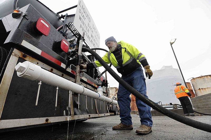
Jon Honeywell, director of Little Rock's Public Works Department, called conditions of the nine primary roadways in the city a "mixed bag" but said that they hadn't seen a spot that was worse than others.
Crews will continue working in 12-hour shifts -- 75 people on the day shift and 50 at night -- to treat streets with a sand and salt mix.
Honeywell said the work would likely last through Thursday morning.
"[We'll] keep plugging away at it until it stops either material coming down or we're able to get it off the streets and people can get around," he said. "We've done this over the last few years. It seems like we've done it a lot.
"So we've gotten a little better, a little more organized, a little more experience added, unfortunately, I guess you could say."
Pulaski County Judge Barry Hyde said the county is dealing with the challenges an ice storm can bring.
"Our folks are as prepared as they can be," he said. "Just ice is the hardest thing because you can't plow it. We try to concentrate on the main roads, the stop signs and the hills."
But, whatever happens, Hyde said, the county will take it as it comes.
"It is what it is," he said Tuesday afternoon. "Our folks will be working all through the next 24 hours trying to keep things as safe as possible."
In the southern third of the state, most highways were clear as of 2:10 p.m., the Department of Transportation's map showed.
U.S. 67 was completely blocked after several crashes, according to the Arkansas Department of Transportation map.
And some of the major highways in southeast Arkansas are partially covered with ice, slush and ice patches, according to the map.
Parker said it had been "all hands on deck" at the Department of Transportation for the previous 24 hours, with "all 10 districts reporting."
"We're obviously focusing on the interstates or primary roads, trying to keep I-40 and 55 (clear)," Parker said, the sound of ice pelting the top of his car loud enough to be heard over the phone. "The predicted ice storm almost follows perfectly the pattern of I-40."
One video posted to Twitter by storm chaser Jordan Hall late Tuesday morning showed traffic backed up for 15 miles on I-40 near Jennette, roughly 20 miles from Memphis, due to a wreck. It also showed power lines covered in ice.
"Our guys out there are now armed in some cases with chainsaws because we've got to clear the roadway," Parker said.
"The main area of concern for the heaviest ice accumulation stretches from near Mena eastward across central into eastern Arkansas," a briefing from the weather service said Tuesday morning.
A tweet from the weather service said that the ice is expected to make "traffic difficult to near impossible" as well as increase the potential for power outages and smaller trees or larger limbs falling.
While the ice made ground travel difficult, it was no picnic in the air, either.
By 3 p.m., Bill and Hillary Clinton National Airport/Adams Field had seen 11 arriving flights canceled with six delays and eight departure cancellations with six delays.
The departing cancellations were primarily destined for the Dallas-Fort Worth area, along with Houston, Denver, Atlanta and St. Louis.
Shane Carter, the airport spokesman, said the condition of the airfield was "slushy" and that a crew of 25 people were on duty to tend to it.
"Our airfield team has been using a broom to try and keep everything just as dry as possible and they'll continue working through the duration of the event," Carter said. "They will be taking breaks and then coming back to work later (Tuesday) evening. ... Then they'll be working also tomorrow. We have several that will be staying the night again in hotels. We have 15 hotel rooms that 15 people will be using tonight. And once the employees get to the airport, we cook and provide everything that they need in order to be comfortable."
Carter said in his 11 years working at the airport, it had only been closed due to weather twice.
POWER OUTAGES
According to Entergy spokesperson Brandi Hinkle, the utility saw a power outage peak of 7,500 customers across the state at about 4:30 a.m. Monday. By 9:45 a.m. Tuesday, the company's outage map showed that that number was down to around 4,000 customers in the state, including roughly 2,500 customers in Mississippi County and 450 customers in Pulaski County.
By 5 p.m., only about 1,600 customers were without power in the state, and 53 in the Little Rock area.
"...We know additional precipitation is likely and could cause more outages in the next 24-36 hours," Hinkle said.
In addition, the Electric Cooperatives of Arkansas outage map showed that over 150 customers were without power as of Tuesday morning, with over half of the outages being located in the Woodruff, Cross and St. Francis area.
SCHOOL PLANS
The school districts in Little Rock, North Little Rock, Pulaski County Special, Cabot, and Watson Chapel announced they will again utilize remote learning today.
All after-school athletic events and extracurricular activities are canceled or rescheduled for Little Rock and PCSSD schools. Afterschool CARE, as well as administrative offices, will remain closed, the Little Rock district said in a news release.
Russellville schools will be closed today and the day will be made up on April 7, the district announced in a news release.
Searcy School District also announced it would be closed.
University of Arkansas-Pulaski Technical College will be closed today. In-person classes are cancelled, but online and hybrid courses may continue to meet at the discretion of the instructor, the school said.
Arkansas State University in Jonesboro has canceled all on-campus classes, and academic and business offices will remain closed.
The student union will be open from 8 a.m.-8 p.m. and the dining hall will be open for brunch hours.
Arkansas Tech University campuses in Russellville and Ozark, as well as Arkansas Tech Career Center, will be closed. All classes will pivot to online learning, and essential services will be available virtually, the school system said.
Southern Arkansas University in Magnolia will also be closed today.
Information for this report was provided by Dale Ellis of the Arkansas Democrat-Gazette.