Arkansas waterfowl hunters endured a deep freeze leading into last weekend, but temperatures will rise as the state's 60-day season reaches its midpoint. There are no more splits left in the season as it runs uninterrupted through Jan. 31.
Long-range weather forecasts indicate temperatures ranging as high as 68 this weekend and staying in the 50s over the next 10 days. While the weather may be mild, the forecast also calls for about 4-6 inches of rain that will cover Delta fields and overflow banks and levees, providing ideal duck habitat. Most of Arkansas Game and Fish Commission's areas managed for waterfowl hunting have plenty of water coverage now, but the ducks could always use more.
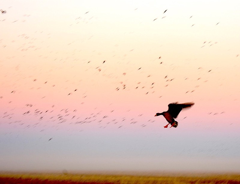
Anecdotal reports surfaced of more mallards arriving as far south as George H. Dunklin Bayou Meto Wildlife Management Area last Wednesday ahead of the cold air blast roared through Arkansas on Thursday. There was only minimal landscape coverage of winter precipitation in the state, but states to the north and northwest received a good blanket of snow and ice. Other anecdotal reports passed along to the AGFC were from private land hunters, who noted more mallards harvested this year than last for the month of December, which fell in line with results of the AGFC's December aerial survey.
In the days leading up to that arctic winter front, AGFC waterfowl biologists completed their December aerial survey, noting the biggest concentration of ducks in the Bayou Meto-Lower Arkansas River, Black River-Upper White River and Cache River survey zones. Of the nearly 1.14 million mallards estimated in the Arkansas Delta during the survey, 75% of all ducks were in those zones. The Delta mallard count numbered 480,846 ducks, the most mallards seen in the December survey count since 2018.
Arctic goose population estimates were nearly 1.3 million along with 181,356 greater white-fronted geese.
NORTHEAST ARKANSAS
BIG LAKE WMA
North Woods GTR Mast production is good. The Bo Dock gauge currently reads 237.4. Target level is 235.7 with 100% flooded.
South Woods GTR Mast production is fair. The 7-mile gauge is currently at 236.2 feet. Target level is 234.5 feet with 100% flooded.
Simmons Field Native production is good in the middle and south fields. 100% flooded.
DAVE DONALDSON BLACK RIVER WMA
Upper Island GTR Moderate mast crop. Current level is 269.35. Target level is 269.5. 100% flooded.
Lower Island GTR Moderate mast crop. Current level is 268.3. Target level is 268.65. 100% flooded.
Upper Reyno GTR Moderate mast crop. Water level is 267.15. Target level is 266.9. 100% flooded.
Lower Reyno GTR Moderate mast crop. Water level is 266.8. Target level is 266.3. 100% flooded.
Winchester GTR Moderate mast crop. Current level is 263.7. Target level is 264.55. 100% flooded.
EARL BUSS BAYOU DEVIEW WMA
South Oliver GTR Mast production is good. Gauge reading on Dec. 20 was 1.45 ft. The area is 100% flooded.
Thompson Tract GTR Mast production has been good. 100% flooded. The Thompson Tract GTR will be allowed to rise and fall naturally without the gates being operated later and partially this season. This action is an effort to help the next generation of forest. Gauge reading on Dec. 20 was 1.9 ft. 100% flooded.
Lake Hogue WRA Primarily deep open water habitat. Normal pool level.
SHIREY BAY RAINEY BRAKE WMA
Adam Brake GTR Good mast crop. Water level is 240. 100% flooded.
Rainey Brake GTR Good mast crop. 100% flooded.
Eagle Pond GTR Good mast crop. 100% flooded.
Phase III Moist-Soil Unit Fair wetland-type vegetation. 95% flooded.
Charles Crisp Moist-Soil Unit Fair wetland-type vegetation. 100% flooded.
Ward Field Moist-Soil Unit Good wetland-type vegetation. 100% flooded.
River Field Moist-Soil Unit Good wetland-type vegetation. 100% flooded.
ST. FRANCIS SUNKEN LANDS WMA
Hunt Area Mast production is good. Water levels in the huntable areas are dependent on the St. Francis River. The water level at Oak Donnick is 212.98. The level for huntable timber is 212.11.
Snowden WRA Mixed grasses are present. 10% flooded.
Payneway WRA Pools A, B, C, and D have mixed smartweed and barnyard grasses, Moderate mast in Pools A, B, and C. Pool A is at 0%. Pool B is at 105%. Pool C is at 35% and Pool D is at 90%.
EAST CENTRAL ARKANSAS
HENRY GRAY HURRICANE LAKE WMA
North GTR Good mast crop. The White River at Augusta on Dec. 19, was 26.57 feet and falling. The water level at Glaise Creek was 191.46. All structures on the North GTR will remain open during the 2022-23 season.
South GTR Fair mast crop. The White River at Augusta on Dec. 19, was 216.55 feet and falling.. The water level at Glaise Creek was 189.53 and falling. All structures on the North GTR will remain open during the 2022-23 season.
REX HANCOCK BLACK SWAMP WMA
Gregory GTR Good mast crop. 40% flooded.
Wyeville Unit Good stand of millet and native vegetation. 90% flooded.
SHEFFIELD NELSON DAGMAR WMA
The Conway George units are currently available for hunting by applying for online permits. Youths may apply for Saturday and Sunday hunts, with one adult hunter allowed per one youth, up to four hunters in the blind. Please visit agfc.com for maps, special regulations, permit application and draw dates. Hunters should call the Wildlife Hotline at 800-440-1477 for current road closures. The AGFC will not put boards in at Dagmar. Water coverage depends on river level.
Mud Slough GTR Good mast crop. 30% flooded.
Apple Lake WRA (No Hunting) Good mast crop. 40% flooded.
Conway George Waterfowl Unit A Good native vegetation. 90% flooded.
Conway George Waterfowl Unit B Natural slough area with beneficial wetland plants. 90% flooded.
Conway George Waterfowl Unit C Good stand of millet and native vegetation. 90% flooded.
Dark Corner Waterfowl Unit 1 Good stand of native vegetation. 95% flooded.
Dark Corner Waterfowl Unit 2 Good stand of native vegetation. 75% flooded
Dark Corner Waterfowl Unit 3 Good stand of native vegetation. 50% flooded.
STEVE N. WILSON RAFT CREEK BOTTOMS WMA
NOTE Hunting in Raft Creek Bottoms WMA requires participation on the online draw a week before the following weekend's hunt. There is no online draw on Tuesdays and Thursdays, and permits are available at the boat accesses. Permits are required (via online application) on weekends, Tuesdays and Thursdays for the youth and mobility-impaired blinds and for the Magellan Tract. Visit agfc.com to apply for the online draw. There will be no designated holes this season.
Unit A Excellent stand of native vegetation. 100% flooded.
Unit B Excellent stand of millet and native vegetation. 100% flooded.
Unit C Good stand of native vegetation. 100% flooded.
Unit D (Youth Area) Good stand of native vegetation. 100% flooded.
Unit E Excellent stand of millet and native vegetation. 90% flooded.
Unit F Good stand of millet and native vegetation. 100% flooded.
Unit G Poor habitat conditions. 30% flooded.
Unit H (Mobility-impaired blind) Excellent stand of native vegetation. 100% flooded.
Unit I Poor stand of native vegetation. 30% flooded.
Unit J (Cypert Tract) Excellent stand of native vegetation. 85% flooded.
Unit K (Cypert Tract) Excellent stand of native vegetation. 15% flooded.
Unit L (Cypert Tract) Fair stand of native vegetation. 10% flooded.
Unit M (Magellan Tract) Good stand of native vegetation. 100% flooded.
CENTRAL ARKANSAS
CRAIG D. CAMPBELL LAKE CONWAY RESERVOIR
Habitat and water levels are normal on both Pierce and Dix creeks.
BELL SLOUGH WMA
Bell Slough GTR Fair mast crop. 20% flooded.
Palarm Creek Rest area was heavily disked late this year and millet crop did not take before the early frost. 80% flooded.
CYPRESS BAYOU WMA
Hunt Area Good mast crop. 90% flooded.
Red Cut Slough Tract Unit 1 Poor habitat conditions. Water level 50%.
Unit 2 Excellent stand of millet and native vegetation. Water level 50%.
Unit 3 Good stand of millet and native vegetation. Water level 100%.
Unit 4 Good stand of native vegetation. Water level 100%.
Unit 5 Good stand of native vegetation. Water level 100%.
Unit 6 Good stand of native vegetation. Water level 80%.
HARRIS BRAKE WMA
Harris Brake Upper Unit Good mast in the GTR. 100% flooded.
Harris Brake Lower Unit Average mast in the GTR. 20% flooded.
HOLLAND BOTTOMS WMA
Hunt Area Excellent conditions. Water level N/A.
Lake Pickthorne (No hunting) WRA Excellent crop of native vegetation and millet. West Unit 85% flooded.
SOUTHWEST ARKANSAS
DR. LESTER SITZES III BOIS D' ARC WMA
Bois d'Arc Lake WRA Closed to hunting. Normal.
Red Slough WRA Closed to hunting. Water level 90%.
GTR Good mast production. 100%.
Little Grassy Habitat is good. Water level 100%.
MILLWOOD LAKE Habitat is good. Water level 259.86.
OZAN WMA
Unit 1 Habitat good. 0% flooded.
Unit 2 Habitat good. 0% flooded.
Unit 3 Habitat good. 0% flooded.
Unit 4 Habitat good. 0% flooded.
Unit 5 Habitat good. 0% flooded.
SULPHUR RIVER WMA
Mercer Bayou Habitat conditions are fair. 90% flooded.
Henry Moore WRA Closed to hunting. 60% flooded.
SOUTHEAST ARKANSAS
BERYL ANTHONY LOWER OUACHITA WMA
The WMA has good hard mast production. The only water on the WMA currently is in the oxbow lakes.
FREDDIE BLACK CHOCTAW ISLAND WMA DEER RESEARCH AREA Habitat conditions are good. There is variable flooding associated with the Mississippi River. Use extreme caution when boating on the river.
TRUSTEN HOLDER Habitat conditions good. Flooding is river dependent.
SEVEN DEVILS SWAMP WMA Habitat conditions good. No huntable water.
CUT-OFF CREEK WMA
Hunt Area Habitat conditions are good. Water is high, but road is accessible.
Pigeon Creek WRA Habitat conditions are good. Fully flooded.
BAYOU METO WMA
Upper Vallier GTR Good habitat. Water level 179.32 feet, full pool at 180 feet.
Lower Vallier GTR Good habitat. Water level 179.09 feet, full pool at 179 feet.
Government Cypress GTR Good habitat. Water level 179.29 feet, full pool at 179 feet.
Buckingham Flats GTR Good habitat. 176.32 msl. First phase of pumping completed.
Temple Island GTR Good habitat. Water level 184.71.
Canon Brake Good habitat. 176.47 msl. Full pool at 177 msl.
Halowell WRA Excellent habitat. Staggered flooding of units.
Wrape Plantation WRA Excellent habitat. Staggered flooding of units.
NORTHWEST ARKANSAS
DARDANELLE WMA
McKennon Bottoms Good native moist soil vegetation. 100% flooded.
Potter's Pothole Hartman Waterfowl Unit West cell has a poor stand of moist-soil vegetation. East cell has an average stand of moist-soil vegetation. 100% flooded.
OZARK POOL
Dyer Lake Cells Cell 1 Good stand of moist-soil vegetation. Cell 2 Poor stand of moist-soil vegetation. Units 1 and 2 are 100% flooded.
Unit 3 South Cell Good stand of moist-soil vegetation and volunteer millet. 25% flooded.
West Cell Good stand of moist-soil vegetation and volunteer millet. 5%.
NIMROD LLOYD MILLWOOD WMA
Nimrod GTR The red oak mast crop is moderate this year as well as the desirable native vegetation growth. Due to abnormally dry conditions, this area is not expected to fill up as fast as in previous years. The water control structures were closed Nov. 15. 90% flooded.
ED GORDON POINT REMOVE WMA
Little Hole (Unit 1) Japanese millet. 70% flooded.
Willow Island Japanese millet and natural vegetation. 100% flooded.
Red Gate Native vegetation. 90% flooded.
Pig Trough (Units 4 and 5) Native vegetation. 70% flooded.
Cedar Ridge (Unit 6) Japanese millet. 80% flooded.
Unit 7A Natural vegetation. 80% flooded.
Unit 7B Japanese millet and natural vegetation. 80% flooded.
Unit 8A Natural vegetation and Japanese millet. 40% flooded.
Unit 8B Natural vegetation. 90% flooded.
Unit 8C Native vegetation. 75% flooded.
Unit 9 Native vegetation. 95% flooded.
Controversy Corner (Unit 10) Natural vegetation and Japanese millet. 90% flooded.
Remmel Marsh Native vegetation. 90% flooded.
Mud Pond (Unit 12) Natural vegetation and Japanese millet. 65% flooded.
Turkey Pond (Unit 13A) Natural vegetation and Japanese millet. 70% flooded.
Turkey Pond (Unit 13B) Natural vegetation. 75% flooded.
Turkey Pond (Unit 13C) Natural vegetation and Japanese millet. 75% flooded.
Teeny Pond (Unit 14) Natural vegetation. 0% flooded.
Salt Lick (Unit 15) Natural vegetation. 70% flooded.
Bobby's Pond (Unit 16) Natural vegetation. 90% flooded.
Race Track (Unit 17) Natural vegetation. 100% flooded.
FROG BAYOU WMA
Unit 1 Good stand of moist-soil vegetation in the upper end, while lower end has been fallow-disked. 100% flooded.
Unit 2 Has been fallow-disked. Unit is rainfall dependent. 100% flooded.
Unit 3 Average stand of moist-soil vegetation on the upper end; lower end has been fallow-disked. 100% flooded.
Unit 4 Good stand of moist-soil vegetation and planted millet 100% flooded.
Unit 5 Good stand of moist-soil vegetation on the upper end; lower end has been planted with Japanese millet. 100% flooded.
Unit 6 Good stand of moist-soil vegetation. Lower end has been fallow-disked. 100% flooded and pumping.
Unit 7 Good stand of moist-soil vegetation. 100% flooded.
GALLA CREEK WMA
Galla Creek GTR Good stands of native vegetation and Japanese millet. The area is stage-flooded in thirds, and the gate has been raised during the first third flooding. The gate will be raised again Dec. 1 and the final time around Jan. 1. 90% flooded.
PETIT JEAN RIVER WMA
Santa Fe GTR Moderate mast crop. 90% flooded.
Sore-Head Moist Soil Unit Excellent stands of desirable native vegetation throughout. 100% flooded.
Slaty Crossing Moist-Soil Unit Due to ongoing waterfowl habitat enhancement projects, this unit did not grow a desirable native vegetation crop this year. Only about half of the unit produced a crop of millet, but the areas that did produce look amazing. 100% flooded.
Black Lands Moist-Soil Unit Moderate stand of desirable native vegetation throughout. Moderate mast crop in the wooded areas. 100% flooded.
Black Lands Duck Area Poor mast in the wooded sections. Moderate to great stands of desirable native vegetation mixed throughout. 100% flooded.
Pullen Pond Due to ongoing waterfowl habitat enhancement projects, parts of the central section and western section of this area is bare ground. Most of the area has a great stand of desirable native vegetation. Water level 20%.
Pond Creek GTR Moderate mast crop with moderate stands of desirable native vegetation in the open lands. 5% flooded.
Slaty GTR Moderate mast crop. 5% flooded.
Blacklands Duck Area Millet, native vegetation. 100% flooded.