With so many new trails around the region, it's good to put one foot in front of the other on some of the first pathways built for hiking decades ago.
That includes Shaddox Hollow Trail in the heart of Hobbs State Park-Conservation Area in east Benton County. The route loops 1.5 miles through the forest, past bluffs and a stream. It's the first trail built at Hobbs, which takes in 12,000 acres and is Arkansas' largest state park. Shaddox Hollow Trail was built in 1989, ten years after the state acquired the park property in 1979.
Mark Clippinger has been superintendent at Hobbs since the park opened. Clippinger and Tim Ernst, well-known wilderness photographer and hiker, laid out the route. Clippinger, Ernst and platoons of volunteers carved out the trail with hand tools.
After Shaddox Hollow opened, Arkansas State Parks contracted with Ernst to build Pigeon Roost Trail, the park's second hiking path, which opened in 1991. Pigeon Roost and Shaddox Hollow are for foot traffic only. Miles of other trails at Hobbs welcome mountain bikers and horseback riders, as well as hikers.
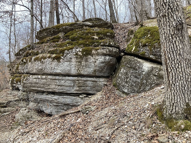
Shaddox Hollow is short on distance, but big on beauty. Hikers pass so close on one bluff line it's easy to scrape an ear on the rock if you're not careful. There are hardwoods and pines mixed in with the rugged landscape. The trail is named after Solomon Shaddox, a pioneer settler in the area.
After enough rain, a stream flows clear and cool through Shaddox Hollow right beside the trail. Kids and kids at heart enjoy poking around in two bluff shelters that are just uphill from the trail. Short spur trails lead to the shelters. Another spur guides hikers to the Shaddox Hollow arm of Beaver Lake. Here water and rock combine for natural beauty worthy of an artist's canvas.
We hiked Shaddox Hollow Trail more often years ago before the menu of trails around the region grew so large. It was good to be hiking again on this picturesque loop during an overcast and misty Friday on March. 5.
So lace up those hiking shoes, and we'll take a little tour of this lovely 1.5-mile route.
Finding the trailhead is easy. Head out to Hobbs State Park in east Benton County. At the intersection of Arkansas 12 and Arkansas 303, drive north on 303 for about a mile. The trailhead and parking is on the left.
We'll hike clockwise around the loop, but it's OK to walk either way. First, we'll sign the trail registry, then start walking to our left.
The path heads downhill for a good little ways through a couple of small hollows. A tiny wet-weather stream pours through one cleft. It's easy to step across without getting wet feet.
The first line of bluffs appears in short order. Here's where the trail runs close to the wall, so be careful not to thump your noggin. We're still hiking downhill, but we'll level out soon along the wet-weather stream, which flows through the hollow and empties into Beaver Lake.
Here's the perfect example of a losing stream. That is, a stream that sometimes disappears underground. Parts of the stream bed are bedrock that's dry as a bone where the flow travels underground. Farther down the trail, crystal clear water emerges above ground again the rest of the way to Beaver Lake.
Now the trail leaves the stream and curves to the right, along another line of low bluffs. There are plenty of rocks for kids to play on and explore. Some wooden stairs mark the start of a climb out of the hollow and up to a ridgetop.
How steep you ask? That's in the legs and lungs of the hiking-stick holder. We'd give it a 6 or 7 on the wheezer scale. It's uphill for maybe 150 yards. There's a great spot part-way up to stop and sit on some big logs cut from a fallen tree.
The root ball of this mighty toppled oak is right beside the trail. Roots have been laid bare. Hikers can see how shallow the root system of trees is over this rocky landscape. Easy does it, and soon we're on the level again, hiking along the wooded spine of a Razorback ridge.
Now is a time to daydream on the easy walk back to the trailhead.
It's fun to hike with friends and chit chat all the live long day. It's great to hike alone, too. Good to stop along the way and just listen. Listen and hear nothing. Faraway traffic or an airplane may break the silence, but quiet is part of the beauty along Shaddox Hollow Trail.
Flip Putthoff can be reached at [email protected]


