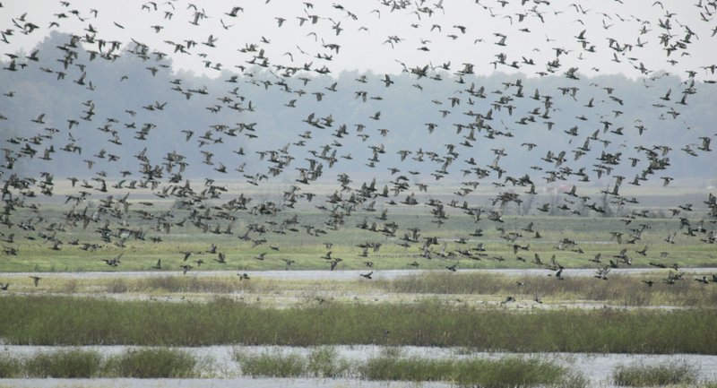
Arkansas Game and Fish Commission biologists estimate 1 million total ducks in the Delta. That is consistent with recent years, but mallard numbers were noticeably down for this period.
The aerial survey was conducted Jan. 7-9 in the Mississippi Alluvial Valley (the Delta), the Arkansas River Valley and in southwest Arkansas. About 500,000 ducks estimated in the Delta were mallards. Mallards typically account for 71 percent of all ducks during the midwinter survey, but mallards only represented 53 percent of all ducks in the Delta in the latest survey. The lower St. Francis had the highest concentration of mallards.
Observers in the Delta estimated more than 1 million light geese and nearly 270,000 greater white-fronted geese.
Duck population estimates in the Arkansas River Valley were 39,620 ducks, about half being mallards.
* Water levels listed in this report were taken Monday and do not reflect any rainfall Tuesday and Wednesday.
NORTHEAST ARKANSAS
BIG LAKE WMA
North Woods GTR Mast production is fair. Bois d'Arc gauge currently reads 237.5. Target level is 235.5 with 100 percent flooded.
South Woods GTR Mast production is fair. The 7-mile gauge is currently at 236.2 feet. Target level is 234.5 feet with 100 percent flooded.
Simmons Field A good amount of millet, smartweed and sedge is present. Seed production is very good in the North Unit. Middle field was planted in Chawapa millet. Coverage is fair. South field was stripped in Chawapa millet. Coverage is fair with strips of smartweed that grew extremely well. 100 percent flooded.
DAVE DONALDSON BLACK RIVER WMA
Upper Island GTR Below average amount of mast crop. Water level is 270.38. Target level is 269.5. 100 percent flooded.
Lower Island GTR Below average amount of mast crop. Water level is 269.65. Target level is 268.0. 100 percent flooded.
Upper Reyno GTR Below average amount of mast crop. Water level is 268.05. Target level is 266.9. 100 percent flooded.
Lower Reyno GTR Below average amount of mast crop. Water level is 267.45. Target level is 266.3. 100 percent flooded.
Winchester GTR Below average amount of mast crop. Water level is 264.85. Target level is 263.7. 95 percent flooded.
EARL BUSS BAYOU DEVIEW WMA
South Oliver GTR; Mast production has been good. The area is 100 percent flooded with a current gauge reading of 1.9 feet. Most water is in the natural slough.
Thompson Tract GTR Mast production has been good. The area is 100 percent flooded with a current gauge reading of 1.6 feet.
Lake Hogue WRA Primarily deep open water habitat. Normal pool level.
SHIREY BAY RAINEY BRAKE WMA
Adam Brake GTR Good abundance of mast crop. Water level is 240 with a target level of 240. 100 percent flooded.
Rainey Brake GTR Good abundance of mast crop. 100 percent flooded.
Eagle Pond GTR Good abundance of mast crop. 100 percent flooded.
Phase III Moist-Soil Unit Good wetland-type vegetation. 100 percent flooded.
Charles Crisp Moist-Soil Unit Good wetland-type vegetation. 100 percent flooded.
Ward Field Moist-Soil Unit Good wetland-type vegetation. 100 percent flooded.
River Field Moist-Soil Unit Good wetland-type vegetation. 100 percent flooded.
ST. FRANCIS SUNKEN LANDS WMA
Hunt Area Mast production is average. Water levels in the huntable areas are dependent on the St. Francis River. The water level at Oak Donnick is 214.05.
Snowden WRA There is a small amount of beneficial wetland plants within the borrow areas. 10 percent flooded.
Payneway WRA Pool D has 14 acres of buckwheat providing good bugging areas when water is available. A, B, C pools have sunflowers left standing with some smartweed underneath. Barrows have been mowed for open-water use. Pool A is at 10 percent. Pool B is at 15 percent. Pool C is at 15 percent, and Pool D is at 50 percent.
EAST CENTRAL ARKANSAS
HENRY GRAY HURRICANE LAKE WMA
North GTR Good mast crop. Glaise Creek gauge at 194.16.
South GTR Fair mast crop. Glaise Creek gauge at 194.16.
REX HANCOCK BLACK SWAMP WMA
Main WMA Good mast crop. 75-80 percent flooded.
Wyeville Unit Good stand of millet and native vegetation. 95 percent coverage.
SHEFFIELD NELSON DAGMAR WMA
Mud Slough GTR Good mast crop. 50 percent flooded.
Apple Lake WRA Good mast crop. 100 percent flooded.
Conway George Waterfowl Unit A Good stand of millet and native vegetation. 100 percent flooded.
Conway George Waterfowl Unit B Natural slough area with beneficial wetland plants. 100 percent flooded.
Conway George Waterfowl Unit C Good stand of millet and native vegetation. 100 percent flooded.
STEVE N. WILSON RAFT CREEK BOTTOMS WMA
Unit A Excellent stand of millet and native vegetation. 100 percent flooded.
Unit B Excellent stand of millet and native vegetation. 100 percent flooded.
Unit C Good stand of native vegetation. 100 percent flooded.
Unit D (Youth Area) Good stand of native vegetation. 100 percent flooded.
Unit E Excellent stand of millet and native vegetation. 100 percent flooded.
Unit F Good stand of millet and native vegetation. 100 percent flooded.
Unit G Fair stand of millet and native vegetation. 100 percent flooded.
Unit H (Mobility-impaired blind) Excellent stand of millet and native vegetation. 100 percent flooded.
Unit I Conditions are poor. 100 percent flooded.
Unit J (Cypert Tract) Excellent stand of millet and native vegetation. 100 percent flooded.
Unit K (Cypert Tract) Excellent stand of millet and native vegetation. 80 percent flooded.
Unit L (Cypert Tract) Good stand of millet. 15 percent flooded.
CENTRAL ARKANSAS
CRAIG D. CAMPBELL LAKE CONWAY RESERVOIR
Habitat and water levels are normal on both Pierce and Dix creeks.
BELL SLOUGH WMA
Bell Slough GTR Poor mast crop. 100 percent flooded.
Palarm Creek WRA Millet was planted as a cover crop within the moist-soil units. 100 percent flooded.
CYPRESS BAYOU WMA
Hunt Area Good mast crop. 55 percent flooded.
Red Cut Slough Tract Unit 1 Good stand of millet and native vegetation. Water level 100 percent.
Unit 2 Excellent stand of millet and native vegetation. Water level 75 percent.
Unit 3 Good stand of millet and native vegetation. Water level 90 percent.
Unit 4 Good stand of millet and native vegetation. Water level 90 percent.
Unit 5 Good stand of millet and native vegetation. Water level 75 percent.
Unit 6 Good stand of millet and native vegetation. Water level 75 percent.
HARRIS BRAKE WMA
Harris Brake Upper Unit Fair mast crop with native vegetation. 100 percent flooded.
Harris Brake Lower Unit Fair mast crop with native vegetation. 100 percent flooded.
HOLLAND BOTTOMS WMA
Hunt Area Good mast crop. 85 percent flooded.
Lake Pickthorne WRA Excellent mast crop. East cell 100 percent flooded. West cell 100 percent flooded.
SOUTHWEST ARKANSAS
DR. LESTER SITZES III BOIS D' ARC WMA
Bois d'Arc Lake WRA Closed to hunting. Normal.
Red Slough WRA Closed to hunting. Water level 60 percent.
GTR Good mast production. Water level 100 percent.
Little Grassy Habitat is good. Water level 100 percent.
MILLWOOD LAKE Habitat is good. Water level 260.13.
OZAN WMA
Unit 1 Habitat good. 100 percent flooded.
Unit 2 Habitat good. 70 percent flooded.
Unit 3 Habitat good. 90 percent flooded.
Unit 4 Habitat good. 90 percent flooded.
Unit 5 Habitat good. 80 percent flooded.
SULPHUR RIVER WMA
Mercer Bayou Habitat conditions are fair. Water level 201.5. Full pool is 199. Boat ramps open as water levels allow.
Henry Moore WRA Closed to hunting. 95 percent flooded.
SOUTHEAST ARKANSAS
BERYL ANTHONY LOWER OUACHITA WMA The WMA has good hard mast production. 100 percent flooded.
FREDDIE BLACK CHOCTAW ISLAND WMA DEER RESEARCH AREA Habitat conditions are good. There is variable flooding associated with the Mississippi River. Use extreme caution when boating in the river.
TRUSTEN HOLDER Habitat conditions good. Flooding is river dependent.
SEVEN DEVILS SWAMP WMA Habitat conditions good. Water level 133 feet. 100 percent flooded.
CUT-OFF CREEK WMA
Hunt Area Habitat conditions are good. 100 percent flooded.
Pigeon Creek WRA Habitat conditions are good. 100 percent flooded.
BAYOU METO WMA
Upper Vallier GTR Good habitat. Water level 180.1 feet, full pool at 180 feet.
Lower Vallier GTR Good habitat. Water level 179.9 feet, full pool at 179 feet.
Government Cypress GTR Good habitat. Water level 179.7 feet, full pool at 179 feet.
Buckingham Flats GTR Good habitat. 100 percent flooded.
Temple Island GTR Good habitat. 100 percent flooded.
Cannon Brake Good habitat. 100 percent flooded.
Halowell WRA Excellent habitat. Staggered flooding of units. 100 percent flooded.
Wrape Plantation WRA Excellent habitat. Staggered flooding of units.
NORTHWEST ARKANSAS
DARDANELLE WMA
McKennon Bottoms Good stand of native moist soil vegetation. 100 percent flooded.
Potter's Pothole Hartman Waterfowl Unit Excellent stand of millet. 100 percent flooded.
OZARK POOL
Dyer Lake Cells Awaiting soybean harvest. Units 1 and 2 are 100 percent flooded. Units 3 and 4 have little water.
NIMROD LLOYD MILLWOOD WMA
Nimrod GTR Fair mast crop. 100 percent.
ED GORDON POINT REMOVE WMA
Willow Island Natural vegetation. 100 percent flooded.
Little Hole Natural vegetation. 100 percent flooded.
Red Gate Natural vegetation. 100 percent flooded.
Pig Trough Natural vegetation. 100 percent flooded.
Cedar Ridge Natural vegetation and Chiwapa millet. 100 percent flooded.
Duck Trap Natural vegetation. 100 percent flooded.
Unit 7A Japanese and Chiwapa millet. 100 percent flooded.
Unit 7B Natural vegetation. 100 percent flooded.
Unit 8A Natural vegetation, Japanese millet and Chiwapa millet. 100 percent flooded.
Unit 8B Natural vegetation, Japanese millet and Chiwapa millet. 100 percent flooded.
Unit 8C Natural vegetation, Japanese millet and Chiwapa millet. 100 percent flooded.
Unit 9 Natural vegetation, Japanese millet and Chiwapa millet. 100 percent flooded.
Salt Lick Natural vegetation. 100 percent flooded.
Bobby's Pond Natural vegetation. 100 percent flooded.
Race Track (Unit 17) Natural vegetation. 100 percent flooded.
Controversy Corner (Unit 10) Natural vegetation, Japanese millet and Chiwapa millet. 100 percent flooded.
Remmel Marsh Natural vegetation, Japanese millet and Chiwapa millet. 100 percent flooded.
Mud Pond (Unit 12) Natural vegetation. 100 percent flooded.
Turkey Pond (Unit 13A) Natural vegetation, Japanese millet and Chiwapa millet. 100 percent flooded.
Turkey Pond (Unit 13B) Natural vegetation. 100 percent flooded.
Turkey Pond (Unit 13C) Natural vegetation, Japanese millet and Chiwapa millet. 100 percent flooded.
Teeny Pond (Unit 14) Natural vegetation. 100 percent flooded.
FROG BAYOU WMA
Unit 1 Sprangle top crabgrass, wild millet and smartweed. 100 percent flooded.
Unit 2 Habitat is poor. 100 percent flooded.
Unit 3 Smart weed, tooth cup, wild millet and sprangle top. 100 percent flooded.
Unit 4 Wild millet, sprangle top, smartweed, nut sedge and crabgrass. 100 percent flooded.
Unit 5 Wild millet, sprangle top and smartweed. 100 percent flooded.
Unit 6 Wild millet, sprangle top and smartweed. 100 percent flooded.
Unit 7 Wild millet, sprangle top and smartweed. 100 percent flooded.
GALLA CREEK WMA
Galla Creek GTR Excellent natural vegetation including a mixture of barnyard and smartweed. 100 percent flooded. Staged flooding began Nov. 15.
PETIT JEAN RIVER WMA
Santa Fe GTR Fair mast crop with native vegetation. 100 percent flooded.
Olin Cain Moist-Soil Unit 25 percent native vegetation and 100 percent flooded.
Black Lands Moist-Soil Unit Native vegetation. 100 percent flooded.
Slaty Crossing Moist-Soil Unit Fair native vegetation. 100 percent flooded.
Pullen Pond 100 acres of Japanese millet and native vegetation. 100 percent flooded.
Pond Creek GTR Fair mast crop, native vegetation. 100 percent flooded.
Slaty Pond GTR Fair mast crop, native vegetation. 50 percent flooded.
Black Lands Duck Area Millet, native vegetation. 100 percent flooded.
Sports on 01/17/2019