6:15 p.m.
The National Weather Service reports several storms will still move through the area this evening and encourages citizens to be weather aware, according to social media posts by the Service.

5:38 p.m.
Another tornado warning has been issued for a portion of Washington County which includes including Springdale, Tontitown and Bethel Heights until
5:05 p.m.
Heavy winds and a reported tornado damaged trees and powerlines Tuesday afternoon in northern Arkansas, and forecasters were continuing to track potential severe storms across parts of the state.
The National Weather Service in North Little Rock said at least one tornado was reported near Bergman, prompting a warning that began around 3:30 p.m. and lasted until about 4 p.m.
An initial tornado warning also covered parts of Washington County.
"I am pretty confident in calling it a tornado," said Dennis Cavanaugh, warning coordination meteorologist at the weather service. "We have seen some pretty telling photos and videos."
The agency said it also observed quarter-sized hail and strong winds as it issued a severe thunderstorm warning for Harrison, Diamond City and Bellefonte.
The weather service, citing Boone County emergency officials, said multiple trees were blown down including one that possibly fell on a home.
No injuries were immediately reported.
Ashley Horton, a dispatcher for Boone County, said officials were still trying to process the amount of damage on Tuesday afternoon.
"We got a lot of damage in Bergman," Horton said. "Trees and power lines are down." Daniels and Sugar roads were closed along with Missouri Avenue because of the storm damage.
The weather service upgraded its risk assessment of storms predicted to move through the northwest corner of Arkansas, saying there the area was under a moderate risk of severe weather.
Cavanaugh said the weather agency sent out a severe thunderstorm warning early Tuesday morning, but the storm seemed to pick up rotation in the afternoon. "We really rely on the information we get from our storm spotters," he said. "We sent out the tornado warning after one of spotters noticed the rotation."
Elsewhere in the state, the weather service said up to six inches of rain could potentially fall by Thursday, raising concerns about flash flooding.
Damaging winds continue to be the main threat throughout the evening and into Thursday, officials said.
Forecasters said the bout of bad weather is expected to leave the state by the weekend.
--Youssef Rddad and Josh Snyder, Arkansas Democrat Gazette
4:15 p.m.
The National Weather Service has expanded the tornado warning for a portion of Carroll County including Eureka Springs.
3:55 p.m.
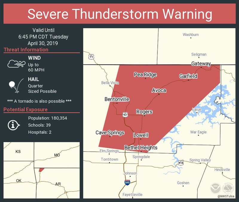
The National Weather Service has issued a tornado warning for a portion of Benton County.
Cities included in that watch include Bentonville, Bella Vista and Siloam Springs.
3:52 p.m.
The National Weather Service reported on it Twitter account that a funnel cloud has been spotted near Watts, Okla.
347 pm...Funnel cloud reported just west of Watts in Adair County. Folks in the Watts Area Take Cover Now! #okwx
— NWS Tulsa (@NWStulsa) April 30, 2019
3:35 p.m.
The National Weather Service has issued a tornado warning for a portion of Washington County.
Cities in or near the path include Summers, Cincinnati and Wedington.
A tornado warning warns the public of an existing tornado, while a tornado watch alerts to the possibility of a tornado.

EARLIER:
A tornado watch was issued over Northwest Arkansas and northeast Oklahoma Tuesday afternoon.
The National Weather Service issued the watch until 11 p.m. Tuesday night.
Forecasters predict widespread heavy rain across Northwest Arkansas along with a possibility of severe weather starting late Tuesday afternoon and continuing through Wednesday night.
The National Weather Service predicts the northwest section of the state can expect to receive 2 to 4 inches of rain by Thursday morning.
According to forecasters, the storms will intensify through the afternoon and could include large hail, damaging winds and a few tornadoes.
A flash flood watch is also still in effect through Wednesday night.


NW News on 05/01/2019