"Let's go chase some waterfalls?"
I sent this message out to several hiking friends I knew would not mind getting their feet wet in the quest for a new adventure. Their resounding response was a simple "Just tell me when/where to meet."
After the isolation resulting from the extended shutdown because of covid-19, everyone was eager to jump on the opportunity for a socially distanced bushwhack in the Ozark backwoods. As an added safety measure, I limited the invitation to four hikers and selected a route that did not involve a shuttle so all could travel in their own vehicles.
In my response to the "When," all I could say was "In three days, maybe?"
I went on to explain that if the rain forecast for the coming two days did develop, we could head out on the following morning. However, if the rain didn't come all we could do was wait for another day.
A hike with the goal of finding waterfalls is totally dependent on rainfall, very recent rainfall to be specific. Tim Ernst, the author of the "Arkansas Waterfalls" guidebook, states that most of the waterfalls he covers are "wet-weather" features. In my experience, when visiting these falls, hikers must be on-site during actual rain to witness the scene on the level of the wonderful photos Ernst has in his books.
As for the "Where," it was a place I had hiked with Jeff Johnson, founder of Arkansas Nature Lover Meetup group — Eldridge Hollow. The day he and I were there had seen no recent rain, and the falls were not flowing; however, it looked promising enough to add it to my list of places to return to — after a good rain. So, all we could do this time was for everyone to keep their fingers crossed that the weather guessers were right.
LET IT POUR
The gauge at my house measured more than an inch of rain the evening before our scheduled hike, with even more to come in the overnight forecast. Even though Eldridge Hollow is about 80 miles from my home in Fort Smith, and I did not know how much rain had fallen in the forest, I sent out the word the hike was a "GO" and to meet at the Oark General Store in northern Johnson County the next morning.
This 1890 establishment, now operating as a full-service restaurant, is listed on the Arkansas Register of Historic Places as the oldest continually operated store in the Natural State. So even if the falls were not running, Plan B was for everyone to enjoy a piece of one of their delicious homemade pies.
As I drove north along Arkansas 103 toward the community of Oark, I inspected the tributaries bordering the roadway to gauge the recent rain. Seeing the splashing waters in these small streams, I was cautiously optimistic. When I reached the outskirts of Oark and witnessed the water level in the Mulberry River approaching its upper banks, I knew we were in for some scenic waterfalls.
Terry Fredrick, Dan Griesse, Norma Senyard, Eric Bernheisel and I gathered under the Oark General Store's newly constructed covered outdoor dining pavilion (built during the pandemic as they're limited to serving carryout foods). I offered the group a choice: begin the hike at the lower end near Spoke Plant Hollow and get the climbing out of the way during the first half of the hike, or start at the top and postpone the climbing to the return trek.
Choosing the latter option, our excited band of adventurers loaded into our vehicles to begin driving up the steep, graveled Arbaugh Road. After 3.6 miles, I veered our caravan left onto Forest Road 1453/1474 for another nine-tenths of a mile, just past the hiker sign for the Ozark Highlands Trail crossing.
There was a small parking area to the right, just past the crossing; however, it is pretty overgrown, so I continued a short distance beyond to a Y intersection and parked on the side of the dirt road in a clearing large enough to accommodate our vehicles.
At this point, hikers could just drop down the mountainside east of the parking area into Eldridge Hollow; however, the topo map contour lines were spaced far apart in that area, indicating there would not be many interesting features to explore. I also preferred beginning our exploration farther up the drainage, so I opted to follow the Ozark Highlands Trail into the upper reaches of the hollow.
I had been through this area on many occasions. I maintained this section when I was the trail maintenance coordinator for the Ozark Highlands Trail Association for seven years, and I also backpacked it many times. I always enjoyed the waterfalls the trail passed, just as many hikers do each year. However, it was not until I went off-trail, down into Eldridge Hollow, that I discovered the beautiful scenery just below the trail.
This is a reminder there are times you need to venture off the beaten path to experience all an area has to offer.
THE HIKE BEGINS
After hiking along the Ozark Highlands Trail for just over a mile, we reached a small stream flowing down the hillside and across the trail. At that point, we veered off the trail to drop down into the upper watershed of Eldridge Hollow.
Mere minutes after leaving the trail, we encountered a series of waterfalls and cascades not visible from the trail.
Everyone was all smiles as our waterfall adventure had officially begun.
It was a beautiful day to be tramping through the pristine, unspoiled forest, with no telltale signs of man/woman's presence, and feeling at one with Mother Nature. Under overcast skies, the golden carpet of freshly fallen leaves and the bright green moss-covered rocks were ablaze in color. The ever-present babbling of the brooks was a pleasant addition, filling the air with a fitting soundtrack.
For centuries, tributaries like the one we now followed have worn down the creases in the mountainside, eating away at the layer cake of interbedded sandstone and shale. These creeks have seeped into tiny cracks and spaces in the rock and then washed away the loose, fractured stones, until a solid wall remained to create the bluffs that formed the beautiful waterfalls we sought.
Continuing past several scenic waterfalls, we reached the lip of a very impressive formation. The edge of the falls formed a crescent-shaped ledge of rock, and below this lip, the floor of the hollow had collapsed to create an open abyss some 40 feet deep and 60 feet across at its mouth.
After enjoying the view of this impressive waterfall from the top, we were anxious to check out the view from the foot of the falls, to experience the water crashing into the pool. With its steep walls and dangerous drop-offs, our only option was to hike beyond the steep banks farther downstream and then backtrack up the base of the falls.
Overcoming obstacles and plotting a way around them is part of the challenge of bushwhacking. As a rule, however, when making a decision, you should always err on the side of caution. Even the smallest injury while several miles from the nearest access road becomes a major issue, not only for yourself but for everyone in your group.
Advancing down the drainage, as feeder tributaries poured down the hillsides to merge with the mainstream, the water volume swelled, and the number of separate waterfalls multiplied.
We witnessed spectacular feeder streams cascading down the mountain from both sides simultaneously into the main channel we were shadowing. Many of these runoffs by themselves were impressive falls, beginning some 50 feet above the creek, flowing down the steep hillside in a series of stair-steps.
Fredrick said he had hiked into the hollow on more than a dozen occasions and not witnessed the volume of water we were experiencing.
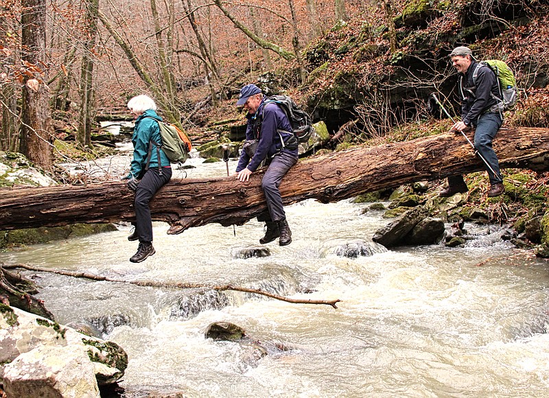
Often, we encountered piles of the huge boulders that had broken away from the hollow's bordering walls and accumulated in the stream's bed. This blockage resulted in a wild array of bustling activity as the waters rushed over and around these obstacles on their journey to merge with Little Mulberry Creek far below. The rubble also made handy, and often challenging, makeshift bridges when we were forced to cross to the opposite stream bank.
There were also tall trees that had fallen across the stream, blocking our paths, causing us to crawl under or over them to avoid having to scramble higher up the steep hillside. However, these too made for handy crossings over the swollen waterway.
PAYBACK TIME
As the drainage began to lose less of its grade and the falls began to peter out, we decided it was time to begin our return journey.
For a change of scenery, rather than backtrack up the stream bed we had come down, we decided to return by a route higher up the ridge. So, we began to scramble up the steep, slippery slope, often crawling on all fours to keep from losing traction and sliding back down.
It was a challenge, climbing up out of the deep drainage, in a manner different from the challenges of hiking along the stream-side. But everyone eventually reached the summit of the ridge, where we found the remnants of a long-ago abandoned logging road.
We followed the faint pathway until it finally vanished, and then, keeping Eldridge Hollow to our right, we made our way back to the Ozark Highlands Trail, exactly where we exited.
Arriving at our vehicles, with adult beverages in hand, we toasted the successful completion of another wonderful outdoor adventure and enjoyed swapping tales of past outings — and those yet to come.
Bob Robinson is the author of Bicycling Guide to the Mississippi River Trail, Bicycling Guide to Route 66 and Bicycling Guide to the Lake Michigan Trail.