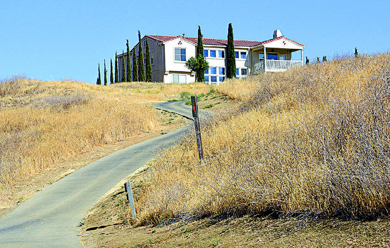
Not long after she bought her home in the grassy hills of western Stanislaus County, Calif., Julie Davis watched as a helicopter filled buckets from a nearby pond and attacked a windswept wildfire burning just outside her community.
The Diablo Grande resort area, where developers envision building hundreds of homes around two upscale golf courses about 8 miles west of Patterson and Interstate 5, was spared. But Davis' neighbors remain watchful. "If anyone sees smoke, almost immediately residents are notified through a social media page," she said.
Diablo Grande is one of several growing communities in California's Central Valley and Sierra Nevada foothills facing a severe risk of wildfire. More than 380,000 people between Redding and Bakersfield live in areas that state and local officials have identified as high or very high wildfire hazard zones, according to a McClatchy analysis of state and local emergency preparedness plans. Tens of thousands more in the Bay Area and Southern California also live in high-risk areas.
The population under threat is rapidly growing. As many as 1.2 million new homes will be built "in the highest wildfire risk areas" of California between 2000 and 2050, according to a 2014 research report by environmental scientists from around the state and country.
Despite the threats facing hundreds of thousands of Californians -- and the still vivid memory of destructive wildfires that have roared through densely populated areas of the state over the past year -- not enough attention is being spent on designing communities to withstand fires or on discouraging rapid growth in once rural areas, wildfire experts and scientists said. Instead, most of the focus has been on blaming public utilities for starting fires and on thinning forestland to reduce the timber that fuels fast-spreading blazes.
"How and where we are building is the under-represented, under-emphasized part of the whole problem," said Max Moritz, a wildfire specialist with the University of California's cooperative extension. "Right now, as the state is burning again, we should be hearing about this accountability issue. But what do we hear right now? Holding utilities accountable. That whole discussion is sort of a distraction from a longer-term conversation about a longer-term solution."
It's also not enough to blame the growing devastation of recent wildfires solely on climate change, researchers said. While drier, warmer conditions have lengthened the fire season and likely increased the severity of the blazes, wildfires are destroying more homes today than decades before only because of rapid growth in rural areas.
In other words, the fires aren't getting closer to people -- people are getting closer to the fires.
"We're seeing wildfires that have always been a part of the landscape that are now interacting more and more with us -- not just because they are getting larger, but because we're building in wildfire prone regions," said Stephen Strader, a researcher and geographer at Villanova University. "If we don't stop what we're doing, this is only going to get worse."
Strader studied wildfire history in the western United States going back three decades, and then mapped population growth in areas where fire activity had ranged from medium to very high. His research found there were 600,000 homes in fire-prone areas in the West in 1940. Today, that number is around 7 million.
"We have to be very careful to readily assume this is just a climate change issue," he said. "It is that, don't get me wrong. But there are two sides to the coin. Fires and society are coming together more often than ever before."
There are few places in the state where the wildfire threat is nonexistent.
In Contra Costa County, the hillside enclaves of Moraga and Orinda are practically surrounded by very high and high fire hazard zones, according to maps released by the California Department of Forestry and Fire Protection. Nearly all of the undeveloped land bordering San Jose and its wealthy suburbs presents a high risk.
More than 4,600 homes in the Sacramento region -- nearly half of them in Folsom -- face an elevated fire risk.
The agency has recommended that officials in nearly 200 cities across the state declare that parts of their cities are in very high fire-hazard severity zones. That list includes major cities like Anaheim, Los Angeles, Oakland and San Diego. Placerville, Auburn and Colfax also face extreme fire risk, the agency said.
Cities and counties have for years been aware of the risks their residents face. Many local governments regularly update local hazard plans that detail the impacts of disasters on their communities, from flooding to volcanoes to drought.
And the threat of wildfire.
At least 262,000 people in Central Valley and Sierra foothill counties live in areas that local fire departments and state officials have identified as very high wildfire risk zones, according to the McClatchy analysis. That includes roughly 66,000 people in Placer County, 60,000 in Nevada County and at least 10,000 people each in Amador, Butte, Calaveras, El Dorado, Fresno and Yuba counties.
Steve Willis, chairman of the El Dorado County Fire Safe Council, said residents in that county acknowledge the "inherent risk" of living under the threat of wildfire. A map released by the state agency in 2007 -- but not updated since -- shows high threat areas around Cameron Park and Shingle Springs. All of Pollock Pines and most of Placerville lie in very high threat zones.
In Sonoma County, where the Tubbs Fire destroyed more than 5,600 structures and killed 22 people, officials of the county and the city of Santa Rosa have begun streamlining the permit process for those seeking to rebuild homes destroyed in the blaze. That includes construction in the Fountaingrove neighborhood, a hillside enclave that was not only largely destroyed by the Tubbs Fire, but was also the site of the large Hanly Fire in 1964.
Redding and Shasta County officials have known for years that the rugged hillsides in that area faced extreme fire risk, long before the Carr Fire swept into Redding and leveled dozens of homes.
Much of the western part of Redding was identified in a city plan a very high wildfire hazard area. A map on the city's website showed that the neighborhoods devastated by the Carr Fire were in that high risk zone.
"Given the topography, climate and vegetation on the west side of Redding, it is ripe and conducive to having fast-spreading wildfires," city officials wrote in a 2015 hazard mitigation plan.
The hazard plan also cautioned against building new homes in parts of the city facing the highest risk.
"The risks associated with future events will continue to increase as the City sees development on previously approved projects in the very high fire hazard severity zone and as new developments are proposed and constructed," the report stated.
California building code requires that new buildings in very high fire hazard severity zones have roofs with ignition-resistant materials, adequate exits and screens covering vents. Some local ordinances require fireproofing of homes during remodeling, according to the state forestry and fire protection agency.
Homeowners insurance rates are also generally higher in areas that the state determines to face very high wildfire risk, said Janet Ruiz, a spokesman for the Insurance Information Institute. Ruiz said insurance companies also will look at a home's age and whether it's in a community designed with fire-defense measures such as landscaped buffers between homes and trees in calculating insurance rates.
However, the ultimate decision to approve home construction in high-risk zones is made by local planning departments. And those departments often do not communicate enough with state emergency officials or their own local public safety agencies, said Stephen Gort, executive director of the California Fire Safe Council.
"That responsibility [to approve homes in fire zones] lies with county planning departments and those county planning departments need to be taking [fire risk] factors into consideration," Gort said. "Why aren't planning departments reading those plans and reacting? It boggles the mind, but how many times in the past have they done it where they design a development where it's one way in and one way out?"
Moritz and other experts said there are steps that planners and policymakers can take to defend homes from wildfire. Some take little effort.
More could be done to provide financial incentives to homeowners seeking to retrofit their homes with fire defense measures, much like the thousands of dollars available to homeowners who strengthen houses to withstand earthquakes. Public agencies could make money available to replace wood shake shingle roofs with fire-resistant material and to place screens on attic and crawl space vents designed to prevent flying embers from entering homes.
A study Moritz co-written with other environment scientists said "relatively untested" strategies can also be used by planners when designing communities in wildfire zones, including placing "irrigated agriculture, golf courses or other land uses" around neighborhoods to "act as buffers to fire."
That study -- which predicted 1.2 million new homes in parts of California facing high fire threats -- said that while improvements have been made in building codes and fire protection, "it is unclear that these efforts will be sufficient to discourage significant high-risk rural development."
SundayMonday Business on 09/16/2018