Born and raised in The Natural State, I thought I had explored all of Arkansas' natural treasures. Then my eyes were opened to Bayou DeView.
For years, en route to other adventures, I drove past the murky, wooded, black waters of the mystery world that borders highways in eastern Arkansas. But I had always motored past; that is, until late May.
I had told Bill Steward, an Ozark Society friend with whom I have dared many an Arkansas adventure, that I was thinking about exploring these wetlands. He told me about someone who might be able to help work up a plan -- Debbie Doss.
"Might be able to help," as I'm sure he was aware, turned out to be a gross understatement, for Doss is the director of the Arkansas Watertrails Partnership. The nonprofit partnership provides volunteer support to the Arkansas Game and Fish Commission's water trails program. The group develops public paddling trails throughout the state, including well-mapped, accessible routes for day and overnight paddle trips.
Also, lucky for me, their focus is on slow-moving bayous, backwaters and sloughs.
Eager to promote these lesser-known waterways, Doss jumped aboard to help plan the adventure, even agreeing to join me on a float.
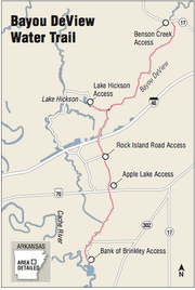
Of the more than 100 miles of water trails already mapped, she recommended Bayou DeView Trail. Lying 70 miles east of Little Rock off Interstate 40, this part of the 83-mile bayou is very accessible, and it offers more than 15 miles of water trails marked with signs.
The trail crosses prime flat-water bayou wilderness. But the information Doss gave me to read said for the water trail to be navigable, the bayou's depth should be 14 feet or higher at the Brinkley water gauge, and with only eight days until our trip, that gauge was reporting merely 12.5 feet.
Doss shared my concern; but she noted that rain was falling just then in the bayou's northern watershed, and that water would take about six days to make its way downhill -- in time for our float. She suggested I monitor the water gauge at Morton, in the north.
Mother Nature must be a water trail fan. The northern watershed received 5 inches of rain eight days before our float, and the area of the water trail had precipitation of its own.
On the first day of our float, the Brinkley gauge read 14.6 feet and rising. Perfect!
THE ADVENTURE BEGINS
After prepping what would be the evening campsite at Lake Hickson, friends and I met up at the Benson Creek Access just off Arkansas 17.
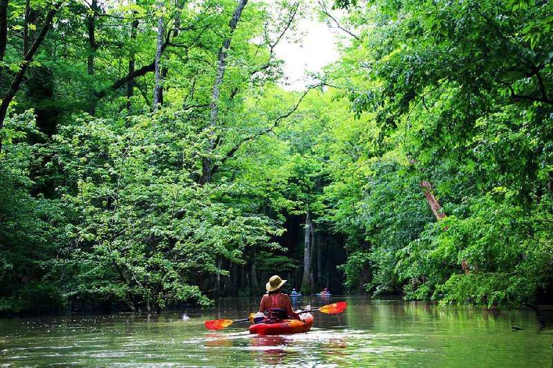
Under sunny skies, our group of five launched an assortment of watercraft, beginning our bayou adventure under a bridge into a 50-foot-wide body of water. Doss veered her canoe to the right, and the rest of us followed.
Shortly into our float, lush green forest began encroaching on both sides, and I saw the first light-blue sign mounted high on the trunk of a tree, designating Bayou DeView Trail's main channel.
As we followed the channel to the boundary of a seemingly impenetrable forest, the current increased, pulling our boats toward a small opening between tree trunks. Leaving the open blue skies behind, we were drawn through the narrow passageway under a canopy of trees, like Alice going down the rabbit hole. Once we entered the tree tunnel directly ahead, there would be no turning back until it spat us out the other end.
Well, not really. The current was barely perceptible, and it would be possible to turn around and paddle back to the vehicles. But, I imagined, we were entering our own Wonderland.
What a wonderful place it was. Inside this unique ecosystem, everyone ceased paddling to drift at the natural bayou pace, our heads on a swivel so as not to miss anything.
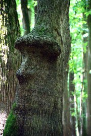
There was no land in sight, just water and tall, healthy trees bearing crowns of nearly fluorescent green foliage. The flooded bottomland forest includes hardwoods, such as oaks and sweet gums. But the majestic tupelos, with their wide buttresses and often twisting and oddly shaped trunks, and the mighty bald cypresses, surrounded by jagged knees, steal the show.
It was such an up-close-and-personal experience I felt as though I was hiking within an old-growth forest, only via a kayak.
The view was unobstructed by underbrush. Peering between and around tree trunks, we had all-encompassing views of even more distant trees and water pools.
Doss said she has floated this trail more than 100 times. As I circled a particularly large trunk, though, I noticed Doss rubber-necking, swept up in the adventure like a first-timer.
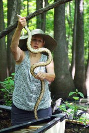
The main channel was mostly obvious and would have been easy to find without the plentiful blue markers. At this high water level, though, there were navigable routes between tree trunks that made for interesting side trips to check out abstractly shaped trees, search for the famed ivory-billed woodpecker, or just to follow our own path.
Doss explained how the partnership's crew had made many float trips to install the blue markers. After finding a general route using maps and GPS, they would return at low water to determine a navigable course, and later they returned at swollen water levels to install the signs high on the trunks where they'd be easy to spot.
It seemed the deeper we entered the bayou, the larger the trees. Doss said this could be true, because the deeper into the wetland the more difficult it would have been to harvest the trees. Some of the giant tupelos and awesome bald cypresses are virgin timber.*
After floating through the trees for a couple of miles we came to an open area. Doss said we would paddle several wide pools along the trail, areas where the water backs up near earthen embankments or a buildup of debris among the trees. But then the channel would narrow once again and resume its path of least resistance in and around the dense forest on its way to join the Cache River.
Note:
To reach the Hickson Lake Access/campground, take Exit 202 off Interstate 40, then go right on Arkansas 33. After 2 miles, turn left on U.S. 70. Drive about 7 miles on U.S. 70 and then go left on Dagmar Road. There is no road sign, but there is a sign for “Sheffield Nelson Dagmar W.M.A.” Ignore another sign for the wildlife management area that shows up at 5 miles that also has a sign for “Conway George Waterfowl Unit.” It is about 7 miles on the gravel Dagmar Road to Hickson Lake.
For more information on water trails within the Natural State go to arkansaswatertrails….
With lunch break approaching, Doss steered us off the signed route to an opening through the bordering trees. To me this looked just like the hundreds of narrow openings we had been passing all morning, but soon we came to a patch of dry land, where we got out and ate.
This was the Benson Creek Natural Area, which Doss explained was being restored to original hardwood bottomland with help from the Nature Conservancy of Arkansas.
BE PREPARED
Returning to the main channel, I realized why the literature advises boaters to carry a map and GPS. The open channels between the trees all looked the same. Without a guide, or a map and GPS, I might still be out there.
After a few more miles of floating we reached a sign for Lake Hickson Access, our home for the night. We followed red signs for less than a mile to the access. This is also a road-accessible campground, where we had set up our camp before beginning the float.
The Bayou DeView Trail easily accommodates a weekend float trip. From the northern terminus at the Benson Access, it is a 6.5-mile float to Lake Hickson Campground. Although it is primitive camping with no facilities or potable water, it is a good camping site on the banks of a beautiful lake, its shores lined by tall tupelo and bald cypress.
DAY TWO
After a restful night of serenades by baritone bullfrogs, we launched our boats from the campground and retraced the red route to the main channel.
Doss' husband, Cowper (pronounced "Cooper") Chadbourn, joined us. He is a member of the Arkansas Canoe Club's Black Ops and Trash Recovery team, working tirelessly to keep waterways trash-free. The team's specialty is removal of large items, such as the 10-foot dumpster they once pulled from the Buffalo River.
Although it did not seem possible, the second day's float was even more impressive than the first, with trees that looked larger and had even more dramatic shapes.
The area was like an art gallery for trees. How were the smaller ones distorted into abstract positions? It could have something to do with the overhead canopy blocking out the sun.
Many of the large buttresses, some 40 feet in diameter, have decayed cavities at their base. Even with hollows in three-quarters or more of the trunk, the tree still sports a crown of healthy foliage.
In this unique natural wonderland, there were trees completely separated at their bases that had grown together to touch for an everlasting kiss.
Once again, for our midday break Doss steered us off the channel to a plot of dry land. Known locally as Whiskey Island, it harbored a moonshine still during Prohibition. Scrounging around, we found shards of thick glass that we assumed had stored the whiskey, and a metal barrel rim.
After our break we continued toward our takeout at the Apple Lake Access. At the pace we were going we decided not to tackle the 4.3 miles to the Bank of Brinkley takeout.
However, before ending our adventure, we paddled around Apple Lake in search of the cypress tree that graces the cover of Tim Ernst's 2010 Arkansas Nature Lover's Guidebook.
And yes, it is as beautiful in life as it is in the picture.
ActiveStyle on 06/11/2018
*CORRECTION: The University of Arkansas, Fayetteville’s Tree-Ring Lab documented in 1985 the age and slow growth of bald cypress tress from Bayou DeView, which includes virgin timber. A previous version of this story inaccurately described the growth rate of the trees.