FAYETTEVILLE -- Residents who live on or near Rolling Hills Drive want to maintain a safe neighborhood for their children, keep cars under the speed limit and prevent incompatible development, city officials heard Thursday during an informational gathering.
Web watch
For an interactive map of Fayetteville streets, go to:
http://bit.ly/fayst…">bit.ly/faystreetsmap
Key dates
• March 6: City Council will consider rezoning 22.6 acres east of Butterfield Trail Elementary School.
• March 12: Planning Commission will take up reclassifying Rolling Hills Drive on the city’s plan.
• March 20: Consultant Nelson/Nygaard scheduled to present a draft of an update to the city’s mobility plan.
All meetings take place at 5:30 p.m. in Room 219 of City Hall, 113 W. Mountain St.
Source: Staff report
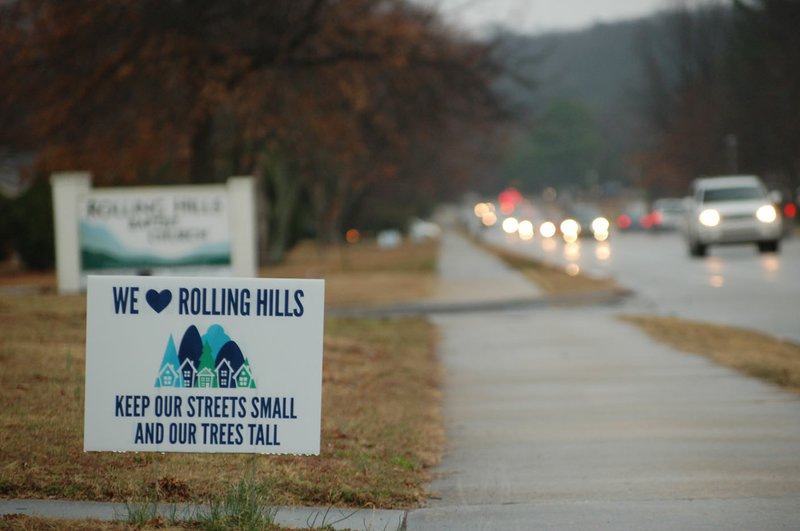
About 200 people packed Rolling Hills Baptist Church to hear about potential plans for the area. Hundreds of signs pleading to "Keep our streets small and our trees tall" lined the street and its surrounding neighborhoods in the weeks leading up to the meeting.
A fervor has swelled over an upcoming rezoning proposal near Butterfield Trail Elementary School and the inclusion of an expanded and extended Rolling Hills Drive on the city's overall street plan. City planners, Ward 3 Council Members Justin Tennant and Sarah Bunch and Mayor Lioneld Jordan fielded questions from the audience.
The extension, which has been on the city's street plan since 2011, would cut through the area proposed for rezoning. The entire 50-acre wooded area east of where Rolling Hills dead ends with Old Missouri Road is privately owned.
About 10 acres within that 50-acre plot, right at the dead end, has already been rezoned. The City Council in July unanimously rezoned the tract from single-family home use to a potential mix of commercial and residential development. No one from the public spoke at that meeting.
Attitudes have drastically changed the second time around. The new zoning proposal coming up March 6 would keep the 20 acres east of Butterfield residential, but with slightly smaller lot sizes and a higher density.
No particular project was submitted with the request, which is the standard process, Planning Director Andrew Garner said.
Several residents asked why the land should be rezoned at all. Garner said it was the property owner's request, and it's the city's duty to review all requests. Planning staff and the Planning Commission, which makes recommendations to the City Council, all supported the proposal.
Residents at the meeting made it abundantly clear they don't want Rolling Hills extended to Crossover or ever turned into a major road. The city has the street classified as an arterial on its master plan. The Planning Commission will take up a reclassification March 12 that would downgrade it to a neighborhood collector street.
Lucas Regnier of the nearby Huntington subdivision pointed out a developer would still include street tie-ins regardless of a planned cut-through. Planners presented various scenarios on a map of what different rezonings or street proposals would look like. One scenario that included roundabouts got a hearty groan from the crowd.
Development Services Director Garner Stoll said a city plan serves as a guide for development. Nothing on the plan is set in stone, nor does it automatically get funding if it's included. Revisions to the plan require council action.
Nicole Claesen said the messaging from city officials is confusing.
"Anytime the city adds anything to any master plan, that implies intent," she said. "As far as the public is concerned, the city plans to do it."
The city hired consulting firm Nelson/Nygaard to update its overall street and mobility plan and has held numerous public workshops throughout the city since spring 2016. The consultants are scheduled to give a presentation on the updated mobility plan during the March 20 City Council meeting.
A webpage, fayetteville-ar.gov/mobility, has an interactive map and form for comments. Dede Peters, the city's community outreach coordinator, encouraged everyone to use the resources available for future discussions. A parks plan update is in the works, for example.
Emily Brickman brought up the council's move on Tuesday to preserve about 230 acres at Interstate 49 and Martin Luther King Jr. Boulevard as a mountain biking and hiking preserve. Other participants also stressed concern about wildlife within the acreage at Rolling Hills and Old Missouri.
"Is there any way that the city could possibly consider all of us, and all of the rest of the city people, who might like green space?" she asked.
Participants also requested speed tables be placed back onto Rolling Hills Drive. Jordan said ones installed a few years ago were removed because of numerous complaints about them.
NW News on 02/23/2018