Beginnings: We began our twenty-one days on the trail from Tuolumne Meadows with a stroll through Lyell Canyon. We were excited to finally take steps on the trail after months of planning.
At our first campsite, Mark Finch-er, with 25 years experience as a park ranger, gave us some good advice about bears. Anything hanging from a tree signals food to a bear. Even tying your pack up could cause a bear to tamper with something they’d ignore if it were sitting on the ground and lacking a scent.
From then on all packs sat unzipped next to tents and we stored scented items and food inside bear canisters. We never had a bear problem.
A first low: My second day was most difficult. It was warm. I felt weak and allowed myself to become a little dehydrated. I forced dinner down and slept. This was going to be more difficult than I’d expected!
I felt much better for day three and fell into a rhythm that sustained. We breezed into Reds Meadow restaurant and had a wonderful lunch.
During the afternoon, I felt guilty watching a hailstorm and rain through the café window while enjoying blueberry pie and four scoops of ice cream.
For the remaining 20 days on the trail, I thought of that blueberry pie every time I looked up at sunny blue skies.
While in the restroom, a toilet became stopped up. A hiker calmly walked out and returned to the stall with a plunger and quickly cleared the problem.
His buddy said, “Your trail name should be Plummer Joe.” I could tell he didn’t care for the name and suggested Plunger as a possible name. He liked Plunger because it was open to many interpretations.
They were hiking the Pacific Crest Trail. I wonder if the name stuck?
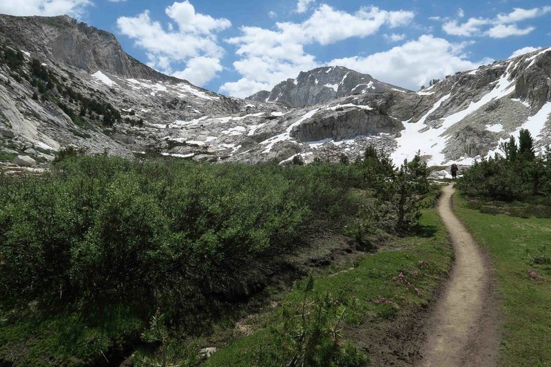
Getting a groove: Part of the rhythm of the John Muir Trail is thinking in terms of seven miles of up or down rather than lots of shorter ups and downs as we often see in the Ozarks.
The patterns of the trail were high passes and stair-stepped glacier-formed lakes. Every pass was an adventure and held unknown challenges of snow, water, boulders and climbs.
Each series of lakes continued to surprise as we ascended, only to learn that the map was correct, and another lake was draining into the one we just passed. These glacial lakes were visual ornaments that sparkled and reflected their surrounding beauty.
We descended a series of switchbacks, and the isolation of Muir Trail Ranch became a reality to me. I expected to see a large sign at the junction marking the spur to the ranch, but a modest sign marked the way.
We had reservations for two cabins. Thus began a true zero-day that was a delight. The outdoor shower was wonderful, and it was a pleasure to wash and hang clothes to dry.
The dining hall served baked salmon and salad, an amazing feast considering our remote location.
Change of plans: After our zero-day, one of our partners spent the night throwing up and felt very ill the following morning. We suggested camping an additional night for recovery time, but Nick wisely decided to leave the trail.
He also took his two sons, so our group of five was now two.
His departure from the trail wasn’t easy. It involved a morning horseback ride lasting over two hours, then taking a ferry across Florence Lake and a shuttle on a narrow hazardous road before finally arriving in Fresno, Calif., at 6 p.m.
For a couple of days, there seemed to be a sense of gloom over the trail because our three friends were not with us.
The beauty of the wilderness was still stunning, and acceptance took hold as we continued our trek, knowing they’d made the right decision for health and safety.
We camped close to McClure Meadows and walked through Evolution Valley before finally arriving a Wanda Lake and camping at 11,434 feet. I took a quick dip in the lake to wash off the trail grunge.
I felt revived by the cold water but was unaware of the beauty that Wanda Lake had planned for us the next morning in 32-degree temperatures. Bob was the first to notice the glassy mirror in the early morning stillness.
Equipment failure: Though minor, my Sawyer squeeze bag sprang a leak. Bob’s water filter was functioning, so pure water wasn’t a problem, but I didn’t like depending on someone else for water. I carefully dried my bag and repaired it with seam seal and Tenacious Tape. The bag worked the next day but soon failed again. More repairs followed, but it was obvious that they did not work.
The next two days we shared Bob’s filter while crossing Mather Pass and Pinchot Pass. We then had a seven-mile trudge upward, camping at Woods Creek next to a masterfully built suspended bridge.
While taking down my tent the next morning, a neighboring hiker learned that my Sawyer bladder had failed. A few minutes later, he walked up and held out a 16-ounce bladder that was in new condition. I thanked him and immediately began to enjoy water independence as I proceeded along the trail.
I learned his name was Joe. Each time I filtered water, I wondered if he had any idea how much his gift was appreciated. Bob reminded me to pass the good deed forward when the opportunity presented itself.
Our next resupply was Onion Valley near the small town of Independence. Topping out at Kearsarge Pass and seeing automobiles in the distance felt surreal. The sun’s reflection on the windshields in the distance seemed out of place.
We enjoyed visiting with a couple who worked in California’s wine industry. Later, we met another couple camping in a van that was several years old but appeared to be in new condition.
The next morning while waiting for Bob’s wife, Dana, to shuttle us to Independence, a hiker sat down at the end of the parking lot. We learned he was injured and needed a lift, so Bob asked him to join us.
We spent three hours visiting over breakfast at the Food Coop in Independence. Keith, our new friend, was able to get a room at the Mount Williamson Motel where we had reservations. We enjoyed getting to know Keith and his wife who arrived later that evening.
I thought about the kindness of Joe in replacing my damaged water filter bladder and Bob’s offer of a ride to Keith, thus beginning a friendship.
Goodwill seems to float around and expand on the John Muir Trail. In every case, we receive much more than we give when sharing that goodwill.
We hiked back across Kearsarge Pass and by early afternoon I was exhausted. Bob could tell by the way I ducked into my tent that I wasn’t feeling well.
While filtering water that evening, he spotted a bear clawing at a dead tree for grubs. The bear continued through the woods oblivious to campers in the area. I missed the bear but was pleased that he’d seen it.
After a good night’s sleep, I felt much stronger. My little episode of weakness made me appreciate all of the other days that I felt strong.
One tough dude: My little time of weakness on the trail was embarrassing when I thought of John Muir exploring this area before there were trails. He was known to grab a loaf of dry bread and take off to explore for a week or so.
Muir wrote more than 300 articles and several books about his favorite natural areas. He was co-founder of the Sierra Club and served as president of the organization until his death.
Construction on this trail that carries Muir’s name began in 1915, the year after he died. The trail was completed in 1938.
It’s a marvel to walk, especially if you’ve done any trail maintenance and realize the difficulty of this work. In some places the trail is blasted from solid rock and in other places, the path is easy and clear.
The construction of stairs impressed me. They could be a challenge when the itinerary called for a multi-mile downhill walk.
After crossing Forester Pass, we camped at 12,200 feet. The next day was a shorter mileage day, and we rested to gain energy for the approaching Mount Whitney.
End in sight: We camped at Guitar Lake above tree line in the shadow of Mount Whitney. During the night we could see the headlamps of hikers approaching the mountain from the other side.
The hike up Mount Whitney went well, and it felt good to drop our packs at the junction and take the spur to the summit. We now stood at 14,494 feet.
While returning from the summit, a couple of young ladies asked, “Are you Jim?” They then said they’d shared a campsite with Dana, Bob’s wife.
They raved about how much they liked Dana and how helpful she was. For a second I wondered how they’d recognized Bob and then thought of his one-of-a-kind beard.
We camped at the Outpost Camp where the approaching departure from the trail began to feel real.
As we hiked the final four miles to complete the JMT, Bob said, “If you see a tear in my eye, it’s just dust from the trail.” We felt a sense of sadness to be leaving the John Muir Trail but knew that our 210-miles of steps in paradise were drawing to an end.