Gov. Asa Hutchinson issued disaster declarations for 36 Arkansas counties and two cities Saturday after last month's severe storms, while residents along the White River continued preparing for rising waters.
RELATED ARTICLE
http://www.arkansas…">Bridge's loss again cuts off home
"We've loaded everything we could lift and put it into an 18-wheeler," said Betty Thurmond, who lives on Spring Lake, just east of Des Arc and the White River. "We don't have water in our home ... yet. But, it's coming across the road."
The National Weather Service forecasts the White River at Des Arc to crest at 36.5 feet at 7 a.m. Wednesday, 12.5 feet above the flood stage. That would be the third-highest level the river has ever reached; the record for the White River in Des Arc is 39.4 feet set on May 7, 2011.
City crews built a 5-foot-tall earthen levee along Arkansas 323 in northern Des Arc on Friday to protect houses in low-lying areas in the Prairie County town.
On Saturday, teams also placed sandbags around homes they thought would be in at least a foot of water at the river's crest, said Davis Bell, a spokesman for the Prairie County Office of Emergency Management.
"People are doing a good job of preparing for this flood," Davis said. "I hate that we have to go through this again after 2011, but the efforts are going so much better this time."
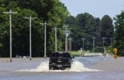
Storms pounded the state on April 29 and 30, dumping 4 to 6 inches of rain on much of an already wet northern Arkansas, knocking power out to thousands, causing flash flooding and spawning tornadoes.
On Saturday, searchers found the bodies of two people who had been missing after disappearing in high waters since the last week of April. Those follow seven other deaths attributed to the storms.
Searchers found the body of a missing man on the Buffalo National River on Saturday morning after he fell from a canoe into the raging waters on April 26, said Buffalo National Park spokesman Caven Clark. The man's body was found about 5 miles downstream from Kyles Landing, where he was last seen.
Saturday afternoon, searchers recovered the body of an 18-month-old girl who was swept away in rapids when her mother's vehicle was washed off a low-water bridge near Hindsville in Madison County on April 29.
Madison County Sheriff Rick Evans said the body of Krystal Wiggins was found about 2:50 p.m. in War Eagle Creek, about 10 miles from where the car entered the water.
Farther north, up to 10 inches of rain fell in south-central Missouri on April 30, causing the Current River to reach record levels in Van Buren, Mo., and Doniphan, Mo. The surge of water rushed south into Arkansas where it flowed into the Black River between Pocahontas and Corning.
On Tuesday, the Black River in Pocahontas reached 28.95 feet, breaking the previous high mark of 28.4 feet set in 2011. Water poured over the levee system southeast of Pocahontas, and nine sections of the levee broke Wednesday morning, sending floodwater into thousands of acres of mostly farmland between Pocahontas and Portia in Lawrence County.
The water eventually flowed back into the Black River in southern Lawrence County and made its way downstream to its confluence with the White River near Jacksonport in Jackson County.
Hutchinson has now declared 36 counties as state disasters. He said last week that he anticipates asking for federal aid as well once waters recede and emergency officials can assess the damage.
The counties are: Baxter, Benton, Boone, Carroll, Clay, Cleburne, Conway, Craighead, Cross, Drew, Faulkner, Fulton, Greene, Independence, Izard, Jackson, Lawrence, Madison, Marion, Mississippi, Monroe, Montgomery, Newton, Ouachita, Perry, Prairie, Pulaski, Randolph, Saline, Searcy, Sharp, Stone, Washington, White, Woodruff and Yell.
The governor also declared Little Rock and North Little Rock as disaster areas, making the cities eligible to receive state funds for cleanup efforts as well.
U.S. Rep. Rick Crawford, a Republican who represents the state's 1st Congressional District, flew over the flooded Black and White rivers Saturday and said he expects damage from flooding to top the $500 million cost from flooding in 2011.
"It's a mess. It's unbelievable," he said of the view between Walnut Ridge and Pocahontas. "It's like you are flying over a big, giant lake."
He said he will assist in obtaining federal disaster funding for the area.
"This is a huge disaster," Crawford said. "But trying to get federal money is challenging in this budget atmosphere."
Several people who live along the White River said they were better prepared for this round of flooding than they were in 2011.
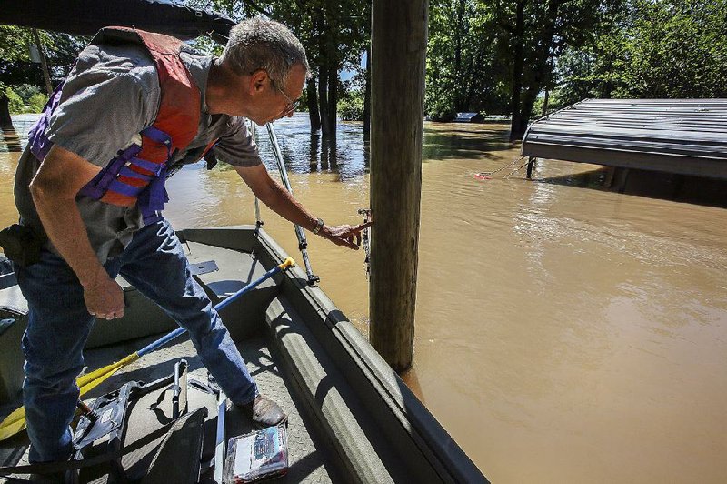
Jerry Allen of Pleasant Plains checked his summer cabin on the White River near Augusta on Saturday where a tree, carried downstream by the flooded river, struck his boat dock. In 2011, Allen measured 33 inches of water inside his home.
Since then, he raised his home 10 feet higher on stilts to avoid any future flooding.
"The river is really churning," he said. "It's moving fast."
Thurmond knew to quickly load her possessions in a truck and leave her home when she heard the river was rising.
In 2011, she lost most of her home.
"Back then, we were 'greenhorns,'" she said. "We had never been flooded out before. Now we know what can happen. It's hard to realize you can go through something like that, but after 2011 we understand.
"I told others who've not seen it before that even if it's green before the river goes up, once the water leaves it will look like death has invaded the land."
Emergency officials have called this flood a "100-year flood," meaning there's a 1 percent chance of a flood of this magnitude occurring each year.
This is the third "100-year flood" in nine years -- flooding reached record or near-record levels in 2008, 2011 and again this year -- causing residents and officials to wonder why there have been so many big floods recently.
"Water management is better than ever," said meteorologist Dennis Cavanaugh of the National Weather Service in North Little Rock. "Levee systems are established, and it may be moving water differently.
"Dredging rivers could help with the flow, but it would be expensive," he said. "It could cost $1 billion or more just to dredge the Black River."
Thurmond said she thinks the rivers run higher because officials haven't dredged years of silt buildup.
"If there's silt in the river, it can't hold as much water when it comes down," she said. "It has to go somewhere."
Bell added that when the state Highway and Transportation Department built a new White River bridge over Des Arc, workers closed four river relief bridges. Now there is only one.
"That has affected Des Arc," he said. "It forces water to back up to east of Des Arc now."
This year's flooding was caused by what meteorologists consider the "perfect storm" scenario.
It's a term they are not fond of using, but it is appropriate when describing events leading to the rising waters.
Before the April 29 and 30 storms, heavy rains had soaked the area so thoroughly that the ground couldn't hold any more water. What fell to the ground immediately ran off, said meteorologist John Lewis of the National Weather Service in North Little Rock.
On April 29 as storms from the Plains moved in, they clashed with an abundance of tropical moisture already stalled over Arkansas and southern Missouri because of a ridge of high pressure to the east.
A second system then "wobbled" in from the west, producing more heavy rainfall, Lewis said.
"Several pieces of the puzzle came together," Lewis said. "Each piece had to fit together to create this big event. That's what we had.
"We had double the moisture level in the atmosphere than what should have been at this time of year."
The White River is expected to remain well above flood stage at Des Arc, Georgetown and Clarendon for at least two more weeks before slowly beginning to recede.
Bell said emergency teams will continually monitor river levels and be available to help anyone in need.
"We've been through this before, but it is emotionally devastating to have to move out of your home because of flooding," he said.
"Your home is your sanctuary."
State Desk on 05/07/2017