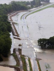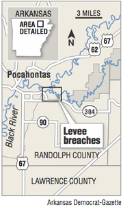
Nine sections of the earthen levee along the Black River near Pocahontas, including a 300-yard stretch, remain gouged by last month's flooding, but U.S. Army Corps of Engineers officials are expected to begin repairing them early next year.
In the meantime, emergency workers are developing plans to plug the gaping holes if forecasts call for torrential rains like the ones that caused May's record river level in the Randolph County town.
"We're looking, if we have another flood event, to come in and do some quick construction work on the levee," said Jim Marple, the Corps' emergency management planner in Little Rock.
Crews would install meshed "baskets" in the gaps and fill them with soil, sand and rocks as a temporary means to curtail flooding in an area where residents have seen three major floods in the past nine years.
The levee also broke in 2008 and 2011, sending water rushing into a subdivision and flooding thousands of acres of farmland south of Pocahontas. Each time, state highway officials were forced to close U.S. 67 between Pocahontas and Walnut Ridge because of high waters.
But despite the three times it has broken in nine years, the levee, overseen by the Running Water Levee District, is considered the "poster child" for maintenance by the Corps, spokesman Laurie Driver said.
The district formed after the 2008 flood and initiated a property tax in 2010 to help pay for levee repairs. Work had yet to be completed when the 2011 flood occurred.
The 8-mile levee system was constructed in 1939 to protect farmland along the winding Black River. Pocahontas sits on a bluff, and most of its residential areas sit high above the river.
Because there were no homes in flood-prone areas for decades, maintenance to the levee was ignored and over time fell into disrepair.
"Complacency set in," said Tony Batey, chief of the Corps' engineering division in Little Rock. "People didn't see the importance of levees."
Unmaintained for decades, the levee began deteriorating, said David Jansen, county judge of Randolph County. Trees grew atop the levee, and their gnarled roots weakened the earth. Animals dug burrows, and builders hauled dirt from the levee to use as foundation when building a retirement apartment complex near the river.
Other people sold dirt taken from the levee, Jansen said.
"We've had a lot of economic development in east Pocahontas since the levee was built," Jansen said. "It's an important part of our town. We need to protect it."
On March 22, 2008, the Black River reached 26.5 feet -- the fourth-highest mark recorded -- and the levee gave way at three places. Water flooded about 100 homes in the Robel addition, a subdivision built near the Pocahontas Municipal Airport and softball complex.
The levee district formed as a result and, after district members touted a property tax for maintenance, voters approved paying $3.40 per acre for five years. The tax concluded last year, but property owners still pay 50 cents per acre in property taxes to continue funding maintenance, said Don Cox, a member of the Running Water Levee District.
"The levee system was totally a mess," Cox said. "It was sadly lacking."
On April 28, 2011, the Black River rose again, reaching 28.47 feet. Sections of the levee crumbled again, and for the second time in three years water cascaded over U.S. 67 , forcing its closure near the Lawrence County line.
Jansen and the levee district continued making repairs after the floodwaters receded.
The Corps rated the work done on the levee as "minimally acceptable" after a 2013 inspection, and it was placed back on "active status" with its Rehabilitation and Inspection Program, meaning it was eligible for federal funding for repairs.
The inspection noted that the district needed to improve its sod cover on the levee to prevent further erosion. Two years later, inspectors said the sod was "excellent" and the levee continued to be on active status.
"Pocahontas did what it was supposed to," Batey said. "They formed a new levee board, found a funding mechanism to pay for repairs with their tax, and effectively notified the community of the need for the levee.
"It's a shame it takes a major event like a flood to propel human action," he said. "But [Jansen] jumped in and tried to find the right way to do things."
The levee breach in May was unavoidable, Jansen said.
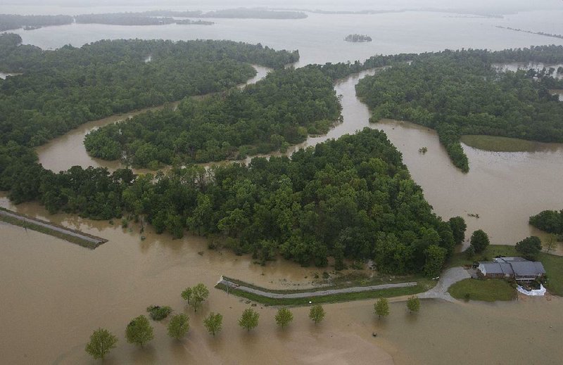
More than 10 inches of rain fell in southern Missouri on April 29 and 30, causing the Current River to reach record levels in Doniphan, Mo., and Van Buren, Mo. The Current River empties into the Black River east of Pocahontas. A glut of water poured into the Black River, and on May 2 the river rose to 28.95 feet, the highest recorded in Pocahontas.
Water poured over the top of the levee.
"It was constantly going over the levee for half a day," Jansen said. "That tells you the levee was in good shape. It was not designed to hold all that volume of water, but it did."
Batey said levees become compromised when overtopped and erode quickly.
Now, with the nine sections of gaps in the levee, if the river reaches 20 feet, it will begin pouring through holes, Jansen said. At 22 feet, the river will cross over Arkansas 304 and 90 and U.S 67. On Friday evening, the Black River was at 7.5 feet.
The river has reached 22 feet 22 times since the levee was built, Jansen said.
"We've got to fix those holes," the county judge said. "If we don't, we're looking at shutting down three major highways in Pocahontas next time we get heavy rain."
Cox said an engineer's study that suggested creating an alternate route for some of the floodwater would cost $38 million. Deepening the Black River channel to help the river's rate of flow would also cost $8 million.
"We've had a lot of thought and a lot of suggestions," Cox said. "Everybody wants the water somewhere else."
Tentative plans for repairing the holes in the levee will cost about $2 million, Cox said.
Marple said he expects the Corps to bid the project in late summer and construction should begin in January or February.
"Generally speaking, whenever anyone builds a levee he is trying to train a river that for eons of time has flowed naturally," Batey said. "Even good levees have limitations."
A Section on 06/26/2017