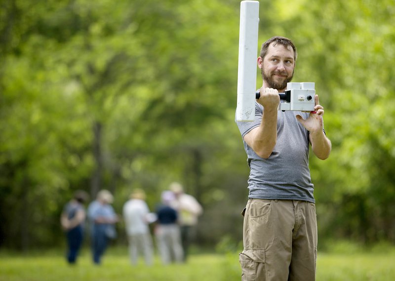
Grid by grid. Line by line. Experts in geophysical remote sensing criss-crossed nearly every meter, every centimeter, of the Leetown hamlet and adjacent cemetery site at Pea Ridge National Military Park. Roughly 30 archaeologists, anthropologists, historians and researchers from around the state, nation and world came to the park for a workshop in the latest technology, presented May 15-19 by the Midwest Archeological Center of the National Park Service in Lincoln, Neb.
The technologies -- magnetometers, conductivity meters, resistivity meters, ground-penetrating radar, metal detectors, magnetic susceptibility instruments and drones -- are all noninvasive techniques available to investigate historic sites. Participants worked "hands on" in the Leetown area of the park. The grassy clearing was the site of a small community during the two-day Battle of Pea Ridge. Historians believe every available building was put into service as a hospital for the wounded at the battle March 7, 1862, in a nearby farm field.
Park arborist identifies tree of knowledge
Jami Lockhart and his compatriots at the Arkansas Archeological Survey have to correlate all the data from each piece of equipment before big discoveries could be made. Archaeologists from around the world descended on Pea Ridge National Military Park last month for a workshop in the latest technology presented by the Midwest Archeological Center of the National Park Service in Lincoln, Neb.
But one big piece of the puzzle came immediately — and not from one of the archaeologists: Curtis Tilghman, an arborist for the national park, recognized a tree.
Lockhart, director of the computer services program for the Arkansas Archeological Survey, showed Tilghman 1960s pictures of the Mayfield home that sat in the Leetown clearing when the park was established. Growing just off the front porch of the house was a small tree.
“It was a catalpa tree,” Tilghman said. “I said, ‘I think I know where that tree is.’”
To the arborist, the tree was easily recognizable by its branch structure, a hole and a “cat face” — a wound in the tree that had grown over, but not completely healed, Tilghman said. “The branches, everything, matched up,” he said.
Today, the behemoth of a tree lays in the middle of the Leetown hamlet site — it blew down just last year, Tilghman said.
Tilghman’s identification showed archaeologists the exact location in the field of the long-gone house and which way the house was oriented, Lockhart said.
The park staff also cut a piece out of the tree, with Lockhart planning to ask a University of Arkansas dendrochronologist to study the ring sequence and determine an age for the tree.
Park Superintendent Kevin Eads also put Lockhart in touch with Greg Mayfield who lives just west of the park, the great-great-great-grandson of Stan “Wix” Mayfield.
His father, who is still living, was born in the 1930s and lived in Leetown.
“I was surprised how many of the family to Mr. Ruddick and Mr. Mayfield are still living in the area,” Lockhart said.
Lockhart, Tilghman and Kevin Eads, park superintendent walked the hamlet site on the last day of the school, with Lockhart explaining the findings.
Then the group waded through knee-high weeds, stepped over a turtle, climbed a fence, faced thorny under brush while walking downhill to a rocky creek bed, then up the creek bed to investigate an well believed to serve the Mayfield home. A rusty bucket for retrieving water was still attached to the concrete well.
“We use every bit of evidence to identify our findings,” Lockhart said.
— LAURINDA JOENKS
Digging history
Archaeology students from the University of Arkansas have taken over the Leetown hamlet site at Pea Ridge National Military Park in a field school and excavation based on the data recorded in the spring and by the participants in the geophysical remote sensing workshop, sponsored by the Midwest Archelogical Service of the National Parks Service.
What: UA archeology field school
When: Through June 30
Where: Leetown hamlet site, Pea Ridge National Military Park
Extra: Visitors are welcome to visit the site and ask questions of students working
Information: 451-8122.
The effort also provided the Arkansas Archeological Survey reams of data in advance of an excavation, starting this week, by University of Arkansas students.
"We are extremely fortunate to have a group of national and international experts present," said Jami Lockhart, director of the computer services program for the Arkansas Archeological Survey and an instructor at the workshop. "Going several times over this place is very important."
"With all the data presented this month, this is really an exciting time," said Kevin Eads, superintendent of the national park.
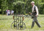
GROUND-PENETRATING RADAR
"Walk straight, and look ahead (to an orange traffic cone on the far side of the field)," urged Salma Abou-Aly, a representative of the company Sensors and Software from near Toronto. Meliha Dogan was pushing a ground penetrating radar device like she would a lawn mower.
The radar uses radio waves to see images under the surface of the ground, Abou-Aly explained. This piece of equipment could then provide a three-dimensional model, an image of a slice at any depth and position using the images in real life and coordinating with Google Earth.
But this equipment -- and others presented at the workshop -- don't reveal an object underground. Rather, the equipment shows anomalies. A difference from the base reading can indicate the presence of something blocking the radar waves, Abou-Aly explained.
An initial look at the results showed an anomaly at the site of a visible depression in the field, believed by park officials to be the remains of the main road through Leetown at the time of the battle. The same readings continued underground from the edge of the depression, perhaps indicating a road did run here and encouraging more investigation, Abou-Aly said.
CEMETERY SITE
Carl Feagans, an archaeologist based in Golden Pond, Ky., with the U.S. Forest Service at the Land Between the Lakes National Recreation Area, said he was eager to try the ground-penetrating radar over 300-plus cemeteries in the national forest he covers.
Feagans got to experiment with the cemetery site adjacent to the Leetown hamlet location. Park officials and University of Arkansas archaeologists confirm the site is a cemetery based on one unique gravestone of a child, dated four years after the battle. But they are unsure if other burials lie in the area, perhaps soldiers killed in action at the Leetown battle.
Field stones lay flat on the other side of the cemetery clearing. "But are they connected to the cemetery?" Lockhart asked. "Any way, we will leave them laying."
Feagans said he can feel the depressions in the known cemeteries as he walks in the Kentucky forest. He felt the same conditions in Pea Ridge.
"We certainly want to know if it's a cemetery, so we can interpret and manage it," said park superintendent Eads. "It is a linchpin in the park. What they find can enhance or even change the story [of Leetown] we talk about. We don't talk much about civilian life before -- and certainly not after -- the battle.
"If nothing else, we would like to know where the graves are to show respect."
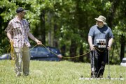
Clare Connelly, an archeological technician with the Midwest Archeological Center, carried an earth-resistance meter across grids at the cemetery site.
This piece of equipment, which could be loosely likened to looking like a garden gate, measured resistance of an electrical current passing through the soil, explained Kris Lockyear, a senior lecturer (similar to an associate professor) in archaeology at the University College of London. Water in the ground conducts the electrical currents, he said. The current flowing through stones shows high resistance, as it is difficult for the current to pass through. But ditches, which might contain water, show low resistance, as electricity easily passes through water.
Measuring resistance can be a slow process, Lockyear said. The user physically picks up the light-weight piece of equipment, setting it down at one-meter intervals. A quick beep of the machine indicates the reading has been taken.
"I suspect, that given the soil here, this (survey) is not going to be very successful," Lockyear said. "But sometimes, I'm surprised."
The equipment works best when searching for stone buildings, roads and historic monuments, but not prehistoric remains, Lockyear continued. Most recently, he has used the equipment to explore a Roman-built road at Verulamium in Hartfordshire, England, about 25 miles north of London. He also works with groups of amateur archaeologists, he said.
TESTING TECHNOLOGY
Using one of the park's split rail fences as a support, David Maki of Archaeo-Physics Geophysical Survey in Minneapolis was conducting an experiment with a relatively new technology -- an electromagnetic conductivity meter, he explained.
"Supposedly, it can map buried objects at a depth greater than a metal detector. But it's not understood yet what kind of signal it would give on a Civil War bullet," he said as he held a bullet between his fingers.
So Maki duct-taped together some plastic dowels and marked them at 5-centimeter interval. He would then place the bullet next to each marking and take a reading, which he jotted down in pencil in a pocket-size notebook. He was noticing changes in the readings at about 30-centimeters along the homemade ruler. "We will have to figure out if it's 'noise' or an actual reading," he said, noting that he will run this same test and many others before the reading will be considered correct.
Nearby, a field was filled with yellow and red survey flags marking hits of ferrous (iron) and nonferrous metals found with state-of-the-art metal detectors.
"Of course, it's all going to be farm scatter," Lockhart said. "But whether it's scattered from 1860 or 1960, we'll have to find out."
Members of the Mayfield family lived in a house on the site when the park was established in the 1960s. The house had been expanded over the years since the war, but parts remained from the original structure built circa 1840.
BY LAND OR BY SEA
Daniel Koski-Karell, a historic and cultural resource specialist (an archaeologist) with the U.S. Coast Guard's office of environmental management in Washington, D.C., might seem like a strange candidate for a workshop based on hard ground.
"The Coast Guard owns a lot of land property, such as boat houses, air stations and training centers," Koski-Karell explained. "And every time the Coast Guard enters a construction project -- which includes updating utilities, installing pipelines or building a hangar -- it must complete a preconstruction investigation."
Many of the older stations now must be renovated to include quarters for females, he added.
"My work also covers architecture and architectural history," he said. "The Coast Guard owns several hundred lighthouses -- 50 or 60 of which are listed on the national historic register." Part of Koski-Karell's job includes completing the paperwork for nominations to that National Register of Historic Places.
"And we have Coast Guard stations up and down the Great Lakes region that were built more than 50 years ago," Koski-Karell contained. "And some of those lighthouses date to the late 1800s."
Decommissioning and transferring the property to another agency or owner also requires investigation.
Koski-Karell currently works with 14 Coast Guard "cutters," some built in the 1940s and 1950s, that have become more expensive to maintain than replace and will be decommissioned, he said.
The equipment shown at the workshop can be expensive, with many agencies and schools not ready to foot the bill, Koski-Karell said. But the equipment can be rented, or he might contract with a company that specializes in such research to complete a survey.
AMERICA EASY
As Dogan pushed the ground-penetrating radar over the Leetown cemetery site, she simply was extending her life-long learning. Of Turkish descent, Dogan currently works at the University of Cologne in Germany as an expert in resistivity, and she served as an instructor at the local workshop.
"I teach students and instruct them, but I am learning my whole life," she said, as she became familiar with an instrument of technology new to her.
Most recently, she has been working at ancient Zeugma, the remains of a third-century Roman military town that has yielded beautiful mosaics, and Gobelslitepe, a prehistoric temple site, dating to circa 10,000 B.C. (12,000 years ago), both in southern Turkey.
"In 1994, (the Gobelslitepe) was nothing but trees," Dogan said. "But they've explored and discovered so many things there. It was built thousands of years before Christ. They knew how to focus worship on God, based on the monuments they erected. It is a very important site in history."
Dogan's daily work "is quite different than working in this (Arkansas) field," she said. "It's easy to get magnetic evidence using GPR. Your history goes only two centuries back.
"It's so easy to discover American history, it's just 1 centimeter below the surface," she said with delight.
NAN Our Town on 06/01/2017