Camp Robinson and Little Rock Air Force Base loom large over the development of a robust east-west traffic corridor in north Pulaski County.
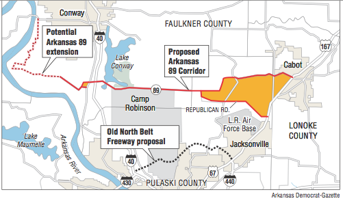
Central Arkansas leaders want to build up Arkansas 89 running from U.S. 67/167 in Cabot to Interstate 40 in Mayflower and beyond as an alternative to the North Belt Freeway, which grew out of favor after its $600 million price tag proved too large.
A yearlong study approved by the Arkansas Highway Commission will determine whether the route, which now is mostly a two-lane arterial road, will need to be widened to three or even four lanes to improve safety and corridor travel time and to allow for truck traffic.
At a meeting of area civic leaders on Wednesday to identify areas of concern, proposed development and other factors that must be weighed in developing the route, there was even suggestion of building it to interstate standards, which include controlled access or interchanges. The meeting was hosted by Metroplan, which is a study co-sponsor and the long-range transportation planning agency for central Arkansas.
But officials with the Arkansas National Guard said part of the route is bordered on the south by a sensitive area of Camp Robinson, which is the main training area for the Guard. That area is protected by a high ridge that can't be encroached upon, they said.
"Just on the other side of that ridge is where we blow a lot of things up," said Col. Scott Stanger, one of three Arkansas National Guard representatives who attended the meeting.
The training includes artillery practice.
"We do make a lot of noise," he said.
Jacksonville Mayor Gary Fletcher and others also want the study's leaders to look at using Republican Road as part of the new east-west corridor and create a new interchange on U.S. 67/167 at what used to be known as Coffelt Crossing in Jacksonville instead of taking the corridor into Cabot on the existing Arkansas 89.
But Stanger said that would take vehicle traffic under the flight path of the big Lockheed C-130 Hercules military transport aircraft that are assigned to nearby Little Rock Air Force Base. The base trains C-130 crews from the U.S. Air Force as well as from the air forces of other nations.
No one from the base attended the meeting, but Stanger said he is familiar with the issue because the Arkansas National Guard has units assigned to the base.
"They will be hugely concerned because of the flight path," Stanger said.
The base is the seventh-largest employer in Arkansas, employing more than 7,700 active duty, reserve, Guard, civil service and contracting personnel, with an annual payroll of $258 million, according to 2016 data provided by the base. The base estimated its annual economic impact at $470 million.
Fletcher said that given the base's importance to the region, he would have second thoughts about extending the traffic corridor through Coffelt Crossing.
"If anything impedes the operations of Little Rock Air Force Base, I will abandon that," Fletcher said.
The study grew out of the realization that the region still needed an east-west connection in northern Pulaski County even though the North Belt had been abandoned.
Planners say that without an east-west corridor, traffic volume, congestion and safety concerns would increase on U.S. 67/167, I-40, Arkansas 107 and other roads in the area. The lack of a corridor also will continue to restrict access from homes in the northeastern part of the county to the jobs and services available in Maumelle and west Little Rock, and leave the region without the circumferential freeway system common in other urban areas.
The area covered by the study, which has been called a "hodgepodge" of state highways and county roads, has already been identified as a major arterial route in the region's long-range transportation plan. Arterials are major local roads that aren't built to interstate standards.
The study engineer, Jeff Pierce, said a traffic study that will assess existing traffic patterns and project future counts will be part of the overall corridor study. He said he anticipates the study will call for a "robust" arterial but couldn't say yet how many lanes would be required to accommodate future traffic.
But given the pent-up demand in the region for an improved connection, state Rep. Karilyn Brown, R-Sherwood, said, "As soon as you open it, [the traffic] is going to justify four lanes."
Jessie Jones, an official with the Arkansas Highway and Transportation Department, said the study also will be able to tell planners how to "phase in improvements" in a way that makes sense instead of building it all at once.
The study "will give us a road map to complete this project," said Casey Covington, deputy director of Metroplan.
The study's cost wasn't immediately available Wednesday.
Metro on 07/27/2017