The remnants of Hurricane Harvey, which devastated the Texas Gulf Coast and set record rainfall totals in that state this week, turned northeast Wednesday on a trek that's farther east than first expected.
Central Arkansas, which earlier this week was expected to be in the storm's direct path, will now miss much of the rain forecast to accompany the system, National Weather Service meteorologists said.
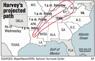
Harvey was downgraded Wednesday to a tropical depression with winds of 30-35 mph as it veered northeast through Louisiana. Forecasters now say the center of the storm will travel through western and northern Mississippi, then into the Ohio River Valley early next week.
Still, southeast Arkansas is expected to receive 4-8 inches of rain today and Friday as the remnants clip that corner of the state. Although the system has lost strength, it can still produce bands of rain that will be locally heavy at times.
"It's going to be dead-eye on top of us," said Chicot County Office of Emergency Management Director Mike Morgan in Lake Village. "One minute we saw Harvey was going west of us, then it was east of us. Now it's right on top of us."
Morgan said emergency officials are preparing for the worst, gathering sandbags and warning residents of the potential for flash flooding.
The National Weather Service issued a flash-flood watch for Arkansas, Bradley, Cleveland, Desha, Drew, Jefferson, Lincoln and Monroe counties in the state's southeast through this evening. Rainfall totals could reach up to 8 inches in Chicot and Ashley counties, said meteorologist Anna Wolverton of the National Weather Service in Jackson, Miss.
"There is still a lot of circulation with this system," Wolverton said. "The maximum amount of rain will fall along the axis of its path through Mississippi, but Arkansas will see a lot of rain, too."
[STORM TRACKER: Follow Harvey’s projected path]
Forecasters initially expected 4-6 inches of rain and strong winds to reach Little Rock about the time the Arkansas Razorbacks are to kick off their football season with a game tonight against Florida A&M at War Memorial Stadium.
Now, the forecast calls for a quarter-inch to a half-inch of rain today with skies beginning to clear later tonight.
Harvey's path was difficult to track, said meteorologist Michael Brown of the National Weather Service in North Little Rock.
Harvey made landfall as a Category 4 hurricane late Friday with winds of 130 mph near Port O'Connor, Texas, between Corpus Christi and Galveston. The storm moved inland soaking Houston, then ambled back into the Gulf, hugging the coast for several days, hemmed in by ridges of high pressure to the northwest and to the east. The system dumped 51 inches of rain near Houston, setting a record for the most rainfall produced by a storm.
It produced widespread flooding and forced thousands of people to evacuate.
Harvey lingered four days over Texas, wobbling along the coast and refueling with moisture from the warm Gulf waters, then soaked Louisiana's coast.
It finally turned inland again Wednesday when the ridge of high pressure parked over the southeastern United States weakened and created a trough for Harvey to follow north, Brown said.
"It was hard to predict its path when nothing was steering it," he said.
Ashley County Judge Jim Hudson said workers in his area were filling sandbags Wednesday at the county yard in preparation for heavy rain. He said some areas of North Crossett flood when the area receives up to 5 inches of rain.
"We'll probably lose some gravel roads," he said. "Everything is already saturated. "Four to five inches of rain won't devastate us, but we will see some flooding.
"Everybody is on point."
A light mist fell Wednesday afternoon west of Crossett.
Barbara Jones, owner of Jones Wrecking and Body Shop west of Crossett, said one of the rental houses she owns in North Crossett tends to flood in heavy rain.
"I'm hoping we'll be OK," she said.
Her daughter lives in Pascagoula, Miss., where rain from Harvey caused flooding near her home.
"It got to within 4 feet of her home," she said. "I thank the Lord she was OK."
Morgan said emergency workers in Chicot County are ready for the rain. Prisoners from the Arkansas Department of Correction's Delta Unit will help fill sandbags today, and officials will monitor creeks and rivers throughout the county.
The Mississippi River at Greenville, Miss., is expected to rise from 18.8 feet to 22.2 feet Saturday as rain runoff begins to pour into the river. However, the river is considered low right now and should be able to handle much of the storm-water runoff, Morgan said.
Farther east in Mississippi, rivers are expected to fill quickly.
The Big Sunflower River in Sunflower, Miss., is forecast to rise from 0.2 feet Wednesday to 17 feet Saturday, and the Tallahatchie River near Sun Lake, Miss., is forecast to go from 8.4 feet Wednesday to 20 feet Saturday.
"We had 11 inches of rain [all at one time] in 2016, and that was more than our 1,000-year flood plan even called for," Morgan said. "We handled it, and we know what to expect now."
RELATED ARTICLES
http://www.arkansas…">Harvey takes parting shots http://www.arkansas…">Relief agencies can't get in to help http://www.arkansas…">Flood survivor, 3, clung to mom's body http://www.arkansas…">State’s lawmakers hold mixed views on disaster relief http://www.arkansas…">Give freely, avoid scams, storm-relief donors urged http://www.arkansas…">Harvey to shut largest oil refinery
A Section on 08/31/2017