Ready to be scared by an authentic haunted house?
Who you gonna call? Ghostbusters?
Links
Map
http://sonoraeast.m…">Get directions to haunted sites in Arkansas from Wyatt Nelson’s story map “Haunted Arkansas: Presented by EAST at Sonora Elementary”
No.
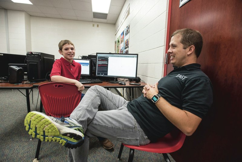
Wyatt Nelson, a fifth-grade student at Sonora Elementary School in Springdale, has created an online map of legendary haunted places in the state. "Haunted Arkansas: Presented by EAST at Sonora Elementary" earned one of eight middle school awards in the recent ArcGIS Online Mapping Contest. The "story map" was created during Nelson's participation in the Environmental and Spacial Technology program at the school.
"It seems ghost stories are very common in the Ozarks," the text of Nelson's haunted Arkansas site begins. "The entire state of Arkansas has its share of supernatural stories and legends of spooky tails that appear from time to time. With historical conflicts like the battle at Prairie Grove in 1962, where over 2,500 people lost their lives, a ghost story is never too far away from the discussion. ... Ghost stories are a part of our legacy and each corner of the state has their fair share of stories to tell."
Featured sites include the King Opera House in Van Buren, the "Ghost Lights" at Crossett, the Bauxite Historical Association Museum, the Cotter Bridge over the White River, the Arlington Hotel in Hot Springs and, of course, the infamous Crescent Hotel in Eureka Springs.
A story map is a term used by the ArcGIS system which lets students "combine authoritative maps with narrative text, images and multimedia content." ArcGIS is a professional, geographic information system provided free to schools nationwide participating in the EAST initiative, explained Josh Worthy, the EAST teacher at Sonora Elementary.
"The contest was intended to showcase the use of geospatial technologies by Arkansas students and publicize the possibilities presented by applying these technologies within a variety of subjects and at multiple grade levels," explained Stephen O'Connell, an assistant professor of geography at the University of Central Arkansas in Conway. O'Connell was Worthy's contact and also a judge for the contest.
"Students (or student teams) were expected to create online maps or map-based presentations to showcase a subject of importance to their community or to Arkansas generally," O'Connell explained in an email. "The potential of subjects was left broad to allow students to explore topics of interest to them, and I think they did that quite well."
Students were required to create at least one data layer to present on their map, which could be as basic as icons on a map identifying specific locations -- such as those shown on Nelson's map, O'Connell continued. Students provided written summaries of their projects, their goals and the data and methods used to accomplish their final projects.
SPOOKY 13
Through internet research, Nelson found several websites listing haunted places in the state and chose 13 to feature on his map, the student explained. But the information he found only included photographs and captions describing the places, so Nelson had to research their addresses and longitude and latitude coordinates to enter into a spreadsheet to plot them on the map, Worthy said. Then Nelson used the source's words as a starting place to write his own captions, Worthy said.
"We have all heard the story of the Hitchhiker of Highway 365," Nelson wrote. "Visitors of Arkansas beware. If you spot a lady hitchhiking home on Highway 365 [near Sheridan], you may find yourself in a sticky situation. Legend has it that this mysterious hitchhiker gives a specific address, but by the time the driver arrives to the destination, the woman simply disappears. Many times the drivers go to the door to ask about the ghastly female [and] finds out that their daughter was killed in a car accident."
The cover story of the haunted Arkansas map sets the tone for the website -- and taught him new lessons. "I have one picture with a guy in the back and all the mist," Nelson said.
The student-teacher team found a nice wooded scene, "but something was missing," Worthy said. "Wyatt wanted to put a ghost in the woods."
The two then found a generic, copyright-free photo of a man walking. By changing the image to black and white and adding opacity, Nelson had his "creepy guy walking." Worthy walked Nelson through the photo manipulation process.
"[Nelson] put in a lot of GIS work, but also got into a little photo editing," Worthy said. "I was glad to see him pick up a new application [to create the opening photograph]."
Although the map covers the state, the 10-year-old was intrigued by what was familiar to him. Nelson said he was particularly interested in the "echoing muskets of Pea Ridge." "During the middle of the night, supernatural spirits echo through the battlefield," Nelson said of reports of musket fire at the national park preserving the Civil War battle sites of 1862.
"Wyatt's map is a great example of how interest in a specific topic and use of available technologies to develop a spatial presentation of that topic can help bring students closer to the places they live," O'Connell said.
At the Cotter Bridge over the White River -- under which Worthy has floated -- the ghost of a woman is chased by the hound through the woods and children play below the bridge, only to disappear when approached, EAST's haunted Arkansas site reveals.
Worthy admitted he is intrigued by the idea of hauntings at the Arlington Hotel in Hot Springs. The national conference for the EAST Initiative will be held next March in Hot Springs, "... which, if Wyatt plays his cards right, he gets to go to," Worthy teased.
The local group will not stay at the Arlington but might pay the haunted hotel a visit, Worthy joked.
Nelson said, of course, he would like to visit some of the creepy sites he included on his map, perhaps "The Haunted House of Mr. Lyle" in Jonesboro, where the 1926 home of local businessman Jimmy Lyle is said to be haunted by the man himself as well as a child running and playing, according to the website.
"It would make a big, long road trip," Nelson said.
And, of course, the map includes the infamous Crescent Hotel in Eureka Springs."We had to put up a creepy picture of the Crescent because that is what haunted Arkansas is known for," Worthy said.
Nelson said he recently visited the infamous hotel with his older brother, Cody Nelson, 22. "We just kind of walked into it to explore," Nelson related. "When we were walking around, we heard some footsteps, but they said everybody had checked out.
"We thought we probably just heard room service," he concluded.
But would the 10-year-old aspiring GIS expert spend the night in the legendary haunted hotel? "I would be so freaked out I couldn't sleep," the fifth-grader reported.
SOLVING PROBLEMS
During independent project time in EAST, Nelson had been working on a map of Big Foot sightings in Arkansas with other students, but the other students dropped the project. Then Worthy saw the contest announcement and got approval to enter the then-fourth-grader in the middle school category.
Teacher and student considered several mapping projects -- the best swimming sites in Arkansas, the best fishing sites ...
"I kind of picked up that Wyatt likes supernatural things," so Worthy suggested ghost sightings.
"The new 'Ghostbusters' movie was coming out, and I was criticizing it, telling the students it couldn't be as good as the first," Worthy admitted.
"But, we hardly looked at any 'supernatural' aspects of the haunted places," he continued. "It was much more about learning the GIS skills in the software and exploring a little bit about the history of Arkansas in all four corners of the state."
Next for Nelson might be a map showing sites where deer with chronic wasting disease have been recorded.
"Chronic waste is a disease in deer where they don't eat and starve to death," explained the young hunter, who clearly has researched the problem. The disease also causes "weird growth in the antlers and losing large chunks of fur," he said.
Nelson reported one confirmed deer with the disease in Madison County, with an elk found in Franklin County. The disease affects 20 hoofed animals, he said.
"Where's our school," Worthy asked. "Where do you hunt?"
"In Madison County," Nelson replied, with Worthy noting the county line, Nelson's hunting grounds and that affected deer did not lie far from the school.
Worthy and Nelson brainstormed about working with the Arkansas Game & Fish Commission to have hunters record on their cell phones locations deer with the disease had been spotted. Then a heat map could reveal area of high incidence of deer with the disease.
Nelson said hunters would not want to hunt in those "hot spots," which would be red, he described from his EAST knowledge of heat maps. Hunters instead would look for "blue spots" where incidents were fewer.
A map of chronic wasting disease and a scientific survey conducted with the the Game and Fish Commission would be a true EAST project because it solves a problem, Worthy said. "And as a fifth-grader, Wyatt has the skills to solve a legitimate problem."
Worthy pointed to one of the winning contest entries on "eliminating book deserts in Northwest Arkansas, " by Ainsley Thresher, Valeria Patino and Brianna Contreras of Helen Tyson Middle School, as such a project.
"The girls created a map that looked at numerous factors to determine what areas within Northwest might be in need of increased access to literacy resources," said Brittany Berry, the EAST instructor at the middle school. "They shared all their work with our partners at the Ozark Literacy Council and used the map to place 20-plus Little Free Libraries in high needs areas. The Little Free Libraries were built through a partnership with the Center for Community Engagement at the University of Arkansas."
"The map from the winners at Helen Tyson focused directly on one location but added a level of analysis -- looking at patterns of population distribution, household spending on books and available transportation -- to answer a specific spatial question about the best places to locate Little Free Libraries within Springdale," O'Connell said. "Students with a passion for reading were disappointed to learn that many people in our community do not have access to age appropriate reading materials at home and are unable to access community resources such as public libraries easily.
"I would add my perspective as a trained geographer and geographic educator and say that I am pleased and encouraged to see students at such a young age engage with spatial topics," O'Connell continued. "Some people have bemoaned the fact that our digital age has the potential of creating a generation that is disconnected from their own surroundings. Geospatial technologies can bridge that gap, allowing users to stay connected with the most advanced software while also investigating interesting spatial patterns and answering questions relevant to their own lives."
NAN Our Town on 10/27/2016