A fire that started 10 days ago near one of the state’s most scenic overlooks was 50 percent contained Tuesday, and the prospect of rain raised hopes of controlling it further.
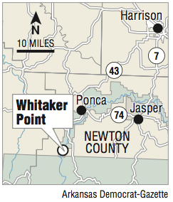
The fire below Whitaker Point in Newton County, the site of Hawksbill Crag, has burned 88 acres of the Ozark National Forest since Nov. 12. The fire is believed to have started from an unattended or incompletely extinguished campfire.
U.S. Forest Service spokesman C.J. Norvel said law enforcement officers are investigating the cause of the fire, noting that overnight camping is not allowed on the bluff near Whitaker Point.
The Forest Service has closed the Hawksbill Crag Trail because of the fire, but many people continued to get on the trail, either unaware of or disregarding the closure, a Forest Service news release said. The news release said the trail could remain closed for the next few days, but fire officials will reassess the status before the weekend if fire lines hold as expected.
The steep, rocky terrain and trees felled by the red oak borer and past ice storms have made it difficult to attack the fire directly, fire incident commander Mike Haisten said.
High winds have blown millions of leaves onto forest floors, reigniting some wildfires in Arkansas’ national forests and intensifying others, such as the Whitaker Point fire, forest officials said.
Haisten said firefighters have used mechanized equipment such as chain saws and leaf blowers to fight the fire.
“But all actions are light on the land to reduce any lasting impacts,” Norvel said in the news release.
A man-made firebreak coupled with natural obstacles such as streams and bluffs are corralling the fire. Norvel said the barrier had not been tested to see if it can stop the fire.
Haisten was cautiously optimistic the firebreak would hold, and he hoped the rain in the forecast would materialize.
The National Weather Service’s website predicted a 60 percent chance of showers and thunderstorms in the Whitaker Point area Tuesday afternoon, a 70 percent chance Tuesday night and then clearing conditions today.
Firefighters will remain in the area for the next couple of weeks to monitor the fire and keep the firebreak clear of leaves, the release said.
The fire line comes close to a few homes and structures in the area, and water tanks and sprinklers have been set up at those locations in case flames threaten them, Norvel said.
No homes have been evacuated, Newton County Search and Rescue coordinator Glenn Wheeler said Tuesday. He also said county personnel have not been called to help fight the fire, but they have notified the Forest Service they would help if needed.
Wildfires have proliferated in Arkansas the past few weeks because of the dry and windy conditions. The Arkansas Forestry Commission said 226 acres burned in 27 wildfires from 3:30 p.m. Thursday to 3:30 p.m. Friday.
The largest fire was in Franklin County, where 1,000 acres northeast of Cass burned last week.
Half of the counties in Arkansas were under burn bans Tuesday and 22 were under the designation of high wildfire danger. The remaining Arkansas counties were under moderate wildfire danger.
According to the commission, 17,774 acres have burned so far this year compared with 14,652 in 2015.
Since 2013, Arkansas has experienced mild wildfire years. The last severe wildfire year saw 34,434 acres burn in 2012.
Since then, heavy rains in Arkansas have resulted in good growing seasons that have produced abundant fuel for fires during dry periods.