Our popular Razorback Greenway has a cousin that welcomes hikers and bikers an easy drive north at the Frisco Highline Trail near Springfield, Mo.
The two paths are similar, yet different. The Frisco Highline Trail runs for 35 miles between Bolivar, Mo., and Springfield Mo., nearly the same distance as the Razorback Greenway. You'll see people on every kind of bicycle. Runners and walkers are out for some exercise, or walking to work, as on the Greenway. Both trails are fairly flat.
Frisco Highline detour
The trail out of Bolivar, Mo., is partially on public roads. From the trail head, go south about one-half mile to Aldrich Road. Turn right on Aldrich. Follow Aldrich about one-half mile and go under Missouri 13. Turn left on the first road past the highway. Go another one-half mile to the outer road and turn left. Go 1.5 miles to a feed mill. The Frisco Highline Trail continues south just past the feed mill.
Or, take the shortcut the locals use. From the Bolivar trail head, go south to Aldrich Road. Cross this road and keep going straight on a trail spur for one-quarter mile until it dead ends at some concrete barriers. Cross the four lanes of Missouri 13 on a dirt trail. The Frisco Highline Trail continues south on the other side near the feed mill.
— Staff report
While our Greenway is hard surface the whole way, the Frisco Highline Trail is about one-third paved and two-thirds crushed limestone. The gravel portion is similar to the Katy Trail that meanders through the heart of Missouri.
The Frisco Highline Trail runs along an old railroad bed, as does the Katy Trail. At 35 miles, Frisco Highline is the second longest rails to trails route in Missouri, with the Katy being longest at more than 200 miles.
The next couple of weeks are prime time for a hop up to Springfield for a day or two of bike riding on the Frisco Highline, as we did on Oct. 23-24. Trees were aglow in autumn color. Miles of the trail run through forests, which form a tree tunnel of yellows, oranges and reds along the easy, flat trail.
The northern end of the Frisco Highline is in Bolivar. The southern end sits at the northwest edge of Springfield. Trail heads and parking are at both ends, with three in between.
Frisco Highline takes bikers into the towns of Willard and Walnut Grove. Riders might stop for a bite at one of several eateries in Willard, eight miles north of Springfield, or at the little convenience store in Walnut Grove, a pretty little town one-half mile west of the trail.
We had an ambitious plan to start in Bolivar and ride the 35 miles to Springfield, spend the night at a motel near the trail head, and pedal back to Bolivar the next day. A torn tire required a trip to a bike shop in Springfield for a new tire, but we still got to pedal most of the Frisco Highline route.
The first couple of miles south of Bolivar are asphalt. Eight miles between Springfield and Willard are paved. The section in between is crushed limestone. The ride from Springfield to Willard is fairly urban. Bikers see the city's airport and a big rock quarry. The ride between Bolivar and Willard is a cycling delight through pastoral, quiet countryside and forest and along a pretty creek.
A tricky part is getting out of Bolivar. The first one-half mile is on paved trail, then the route is on public roads for a few miles until it's trail again. It's poorly marked, if it's marked at all.
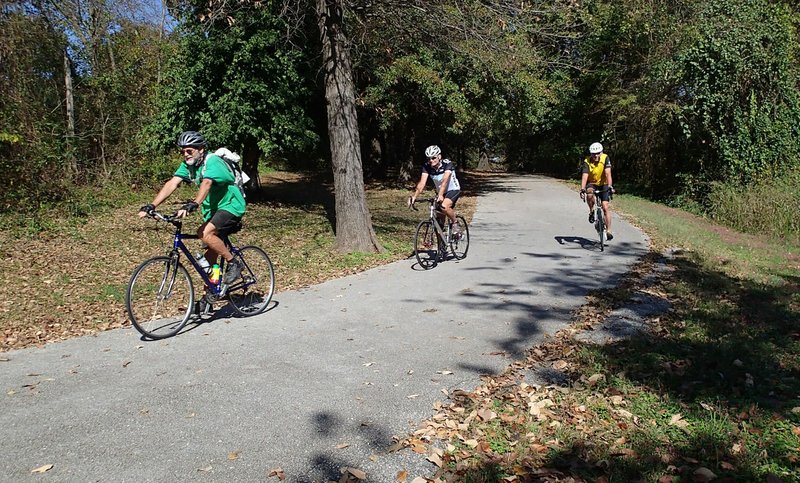
We might still be in Bolivar if it wasn't for three local riders we met who set us straight. They not only gave us directions, but showed us a shortcut the locals use that eliminates the public road detour. Check out the inset with this story for directions.
One of the riders, Jay Heselton of Nixa, Mo., recommends the Frisco Highline Trail to all who like to bike.
"Anybody can ride it. There's very little elevation change since it's an old railroad," he said. "Some of it follows a creek. There's a lot of neat bridges."
Lots of them indeed. Sixteen in all between Bolivar and the Walnut Grove trail head. None are big-span bridges with overhead beams, but small ones maybe 50 or 60 feet long.
There's a restroom at the Bolivar trail head, but no more public restrooms or water spigots, along the route. Riders can find both in Willard or Walnut Grove.
The Frisco Highline Trail is worth the drive to ride of a day, maybe two. We'll definitely return to pedal the whole enchilada, Bolivar to Springfield to Bolivar, if the tire gods cooperate.
Flip Putthoff can be reached at [email protected] or on Twitter @NWAFlip.
Sports on 11/01/2016