WEST MEMPHIS -- The Natural State has a spiffy new bicycle-tourist attraction, and I'm not talking about the refurbished Harahan Bridge, although that's attractive, new and part of it.
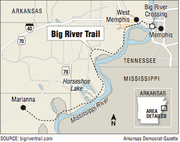


I'm talking about a 73-mile walking-and-biking trail on riverside levees from West Memphis to Marianna.
The Big River Trail was "five years in the making," as the press was reporting when a group of friends and I decided it was high time to check it out. So we loaded up the bicycles to set out on our "Big River Adventure."
The origin of the trail can be traced back even further, to 2009 in Memphis, when Charles McVean began manufacturing hybrid bicycles. McVean is chairman and chief executive officer of McVean Trading & Investment LLC and owner of Aerobic Cruisers Hybrid Cycles LLC. Realizing that the Memphis area offered very little infrastructure to ride the bikes he was building, he came up with the idea of converting the Harahan Bridge, a 100-year-old railroad bridge over the Mississippi River, into a bicycle/pedestrian crossing.
The bridge conversion developed scope-creep when McVean began to consider where people would ride once they crossed the river and reached the Arkansas shore.
Not wanting it to be known as "the bridge to nowhere," he gave this issue much consideration before arriving at the obvious solution. Create the Big River Trail, a bicycle or walking path on top of the Mississippi River levee, which stands just a short distance from the west access for the bridge (off Interstate 55) and extends all the way to Marianna.
Obtaining permission to allow bicycles and pedestrians on top of the levee was no easy task. Sections of the levee in the St. Francis District had not been open to public use since 1893.
After five years of working with various associations in charge of the levee, he still lacked approval for a trail. Then McVean hired Terry Eastin of Fayetteville and formed the Big River Strategic Initiative to execute his vision.
Eastin, Arkansas Delta Byways' Delta Tourism Person of the Year for 2015, has been chief fundraiser and coordinator of the National Geographic Geotourism Initiative, executive director of the Mississippi River Trail Inc. and a core team member for the Walton Family Foundation-backed advocacy group Mississippi River Cities and Towns Initiative.
We decided that our adventure should begin with bicycling across the Harahan railroad/bicycle/pedestrian bridge, which is now called Big River Crossing. The bridge serves as the connection point in a 10-mile, multi-modal Main Street to Main Street project linking Memphis to West Memphis.
At almost a mile, Big River Crossing is the longest pedestrian bridge across the great river. The bikeway piggybacks off the 1916 Harahan Bridge. This century-old bridge was constructed with two rail lines in the center and roadways cantilevered off each side to accommodate vehicles, which at that time consisted mainly of horse-drawn wagons. (The roadway was used until 1949.)
Big River Crossing gives pedestrians use of the former vehicle lane on the north side of the still active railway, for the great upriver views it offers. At the opening ceremony Oct. 22, a steady stream of pedestrians and bicyclists flooded the walkway all day and into the night, marveling at the Memphis skyline and the mighty river.
SPEAKING OF TOURIST DOLLARS
Arriving in West Memphis the afternoon before our long ride, we decided to go ahead and bike the Big River Crossing. We were staying at Tom Sawyer Campground beside the levee and so had just a five-mile ride -- on the trail -- to reach the bridge.
Even weeks after the grand opening, when our group bicycled across, the bridge was still drawing a crowd. It appeared to be the most popular attraction along the riverfront.
At the Memphis entrance and before riding under the archway and onto the bridge, we hopped onto the adjoining Riverwalk Bike Path. A picturesque two miles beside the river later, we veered off the path onto Beale Street to sample some of Blues City Cafe's "world famous" juicy ribs and crispy catfish.
We then topped off the meal with a stroll along the street where music legends including Elvis and B.B. King once walked. A distinctive mix of blues and rock 'n' roll drifted from music venues' open doorways.
BIG VIEW
It is difficult to appreciate just how long the bridge is until you're on it.
When we reached the Arkansas shore, we looked down from our elevated position on the bridge at a grand prospect -- the site of the planned Delta Regional River Park. Construction of the park is scheduled to begin in the spring or early summer. When finished, it will feature a serene natural setting for visitors to bicycle on a seven-mile paved path or just relax and enjoy closeup views of the Mississippi topped by the Memphis skyline.
We exited via Big River Crossing's western access, and after coasting down a fun, corkscrew-banked turn that quickly descends from the bridge's elevation, our group pedaled along the paved path about a mile. Then we took a sharp left to reach the top of the levee.
As I mentioned, McVean had worked five years, to no avail, to open the levee. Just six weeks after Eastin's hiring, after meeting with the U.S. Army Corps of Engineers and receiving their endorsement, the Big River Strategic Initiative signed and presented to the St. Francis Levee District board a memorandum of understanding detailing the responsibilities of all the parties involved in the trail. The board then unanimously approved and signed it, thus opening the levee top to bicycles and pedestrians.
McVean calls her "Bulldog." But Eastin says that once she explained his vision of the economic development opportunities a Big River Trail would offer and how it could foster new enterprises compatible with the Delta's agriculture industry, opening the levee was an easy sell.
FAT TIRES
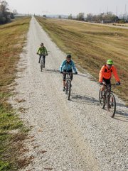
The levee is topped with fairly large gravel. Although we found it very ridable, I recommend using 2-inch or wider tires, such as those on a mountain bike.
According to Eastin, the Corps of Engineers has agreed to limit the size of gravel used in future maintenance projects to half an inch or smaller, which will make the surface suitable for bicycles sporting thinner tires.
One of the first things I noticed while biking atop the levee was how much higher we were than the vehicles on the highway that at times parallels the trail. I had picturesque views of either the Mississippi or the densely wooded ecosystem of its floodplains, whereas a motorist gets a fine view of a grass-covered hillside.
My vantage of more than 20 feet above the surrounding flat river bottoms afforded unobstructed infinite views, and I felt as though I had been granted a super power.
MEANDERING
During the first miles we encountered 36-inch-wide metal cattle guards through which cyclists and pedestrians can pass but cows can't. Here was the physical realization of a simple solution to one of the final obstacles that had blocked public access to the levee: ranchers' concerns that their livestock would escape if someone left a gate open. These cattle guards were funded by a grant from the Arkansas Economic Development Commission.
If you follow the trail on a map, you notice that the Mississippi River doesn't pay attention to human borders. Without crossing the river, you pass from Arkansas into Tennessee and back to Arkansas, then into and out of Mississippi.
Nowhere is the river's meander more evident than about 33 miles into the ride, where the water at one time made a 90-degree right turn and traveled approximately five miles northwest only to circle around and return to the main channel less than two miles down from where it exited. Over time, the river cut a direct route across these two points, thus sidelining the landlocked, U-shaped body of water now known as Horseshoe Lake. We passed several such oxbows.
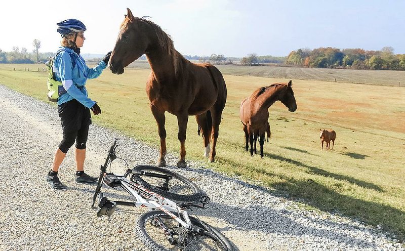
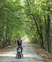
During the first half of our tour from Memphis to Marianna, we were flanked by rich, dark soil to the right and thick, dense forest on our left. Isolated by the levee, these wooded environments offer great opportunities while bicycling for spotting deer, bobcats, armadillos and other wildlife, along with the waterfowl that follow the river on their annual migrations.
Through the middle section of the 73-mile ride, as we worked our way around Midway Lake, on the river-side of the levee we enjoyed enchanting views of ancient cypress trees protruding from the dark, motionless waters of the bordering wetlands.
With the later section of the levee trail open to motor vehicles, we saw camouflaged duck blinds and trotline jugs afloat on the water's surface -- evidence of hunters and fishermen taking advantage of the easy access.
Having divided our Big River Adventure over two days, after a cumulative six hours in the saddle -- and an equal amount of time off the saddle, checking out scenery and munching tasty snacks -- we arrived at our destination, Marianna.
LONG-RANGE PLAN
Eastin describes the Big River Trail as a work in progress. The grand plan is a trail along the 2,500 miles from the Mississippi headwaters at Lake Itasca in Minnesota to the Gulf Coast, including 1,607 miles atop levees along the lower Mississippi.
Big River Strategic Initiative partners are already at work to extend the route to Arkansas' southern border.
Twenty miles south of Marianna, in the town of Lexa, is the trailhead for the Delta Heritage Trail. When completed, this former Union Pacific Railroad rail bed will contribute another 84 miles to the vision. En route to Arkansas City, the Delta Heritage Trail will cross long trestles through vast wetlands as well as the expansive White River.
This historic rail-to-trail conversion is being developed in phases by Arkansas Department of Parks and Tourism, with work progressing inward from each end. Currently, at the northernmost extremity, they have completed 21 miles of compacted, crushed rock trail offering a smooth ride through Delta farm regions.
From the southernmost point in Arkansas City, 14 miles of paved surface paths head north.
Eastin's enthusiasm for these projects is monumental. The Mississippi River does not stop at Arkansas' southern border, and neither does she. Already she is working on plans to open the levee all the way to New Orleans.
ActiveStyle on 12/12/2016