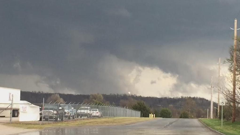
A possible tornado in the first round of Wednesday’s severe weather was tracked by radar in the Beaver Lake area just before 5 p.m., according to the National Weather Service.
First responders were unable to find damage on the ground to match a spotter’s report of tree damage in the War Eagle area, said Robert McGowen, emergency management director for Benton County.
“If there was one we have not been able to confirm it,” McGowen said.
The search for damage was all based on drive-by inspections. Earlier in the evening the rain was so heavy
“It’s so rural it’s possible we might have to find it from the sky,” he said.
Radar indicated a tornado at 4:49 p.m. Wednesday, according to the National Weather Service. A tornado warning was issued at 4:51 p.m. that touched eastern central areas of Benton County, west central areas of Carroll County, northern Madison county northwestern Washington County. Locations in the path of the weather included Sonora, Monte Ne, War Eagle, Hobbs State Park, Clifty, Best, Beaver Lake, Larue, Lookout and Bland. A second warning was issued at 5:02 p.m. noting low-level rotation and the possibility of tennis ball-sized hail. The storm was then 5 miles east of Lowell.
There had been no calls reporting loss of life or damage to property to Benton County Central Dispatch at 5:50 p.m., shortly after the storm moved through.
The Larue community had golf ball-sized hail.
There was still hail on the ground more than an hour after the storm had passed, said Rick Loots. The storm cracked two car windshields and dented a metal roof at his house in Larue. The house was vibrating with the force of the hail, he said. A neighbor lost a greenhouse to the storm.
The hail was about 2-inches across and filled the gutters leaving rain flowing over the edge. The ground was white and covered with hail. He estimated there was still a half-inch of hail on on the porch — and that they had tried to sweep off — an hour after the storm. About 20 percent of the hail that fell was still melting in his yard.
“There was a lot of it,” he said.
People in Clifty reported hail anywhere from a quarter-inch to golf ball sized hail, said Meredith Miller, owner of Clifty General Store. The storm went north of the store as she watched but people called in and told her a barn blew away on Arkansas 127 about a mile north of the store and trees were down in the road. Another customer called and said the roof was gone from a barn on Arkansas 23.
“I had people calling in like crazy,” Miller said.
Amye Buckley can be reached by email at [email protected] or on Twitter @NWAAmye.
We saw this east of our office in north Springdale.
Posted by NWADG on Wednesday, March 25, 2015