Several river tributaries that eventually feed into the Arkansas River began receding Wednesday, but officials continued to monitor flooding along levees, creeks and spillways.
RELATED ARTICLE
http://www.arkansas…">Flooding forces towns to empty
The U.S. Army Corps of Engineers continued the release of 70,000 cubic feet of water per second from Missouri's Table Rock Lake into the White River, which was receding near Batesville, officials said. Days after releasing water from Beaver Lake in Northwest Arkansas, the Corps said the lake was down to 1,129 feet and falling.
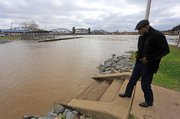
Still, everyone is keeping an eye on the Arkansas River, which is expected to create near-record river crests in the coming days.
In Little Rock, the river is expected to crest at about 26 feet Friday, a 6.8-foot increase from Wednesday's elevation, said Jay Woods, a spokesman for the Corps. Such a height would be second only to the 1990 floods -- when the river crested at 27.5 feet -- in the decades since the 1971 completion of the McClellan-Kerr Arkansas River Navigation System of locks and dams.
On Tuesday, the city's public works staff helped Pulaski County Levee District No. 2 close five levee gates by the Bill and Hillary Clinton National Airport/Adams Field.
Little Rock residents living near Fourche Dam Pike were asked to watch for any signs of flooding, as the river cresting would cause Fourche Creek to spill over, city spokesman Jennifer Godwin said.
The flooding has already prompted park closures, including Boyle, Hindman, Kanis, Murray, Rebsamen Golf Course and the William E. "Bill" Clark Presidential Park Wetlands. The city has also placed barricades at the north end of Two Rivers Park and near the restrooms west of the Two Rivers Bridge, Godwin said.
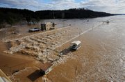
High waters were snaking their way down the Arkansas River from Oklahoma and Northwest Arkansas on Wednesday.
Flows on the river ranged from about 390,000 cubic feet of water per second at the crest in Van Buren to about 435,000 cubic feet of water per second at Dardanelle, the Corps said. Normal river flows are about 30,000 to 70,000 cubic feet of water per second.
A small-craft advisory was still in effect.
Late Wednesday, Gov. Asa Hutchinson added Bradley, Clay, Desha, Faulkner, Greene, Johnson, Randolph, Scott, Sevier, White and Yell counties to the list of disaster areas. That brings the total number of counties declared disaster areas to 32, nearly half of the state's 75 counties.
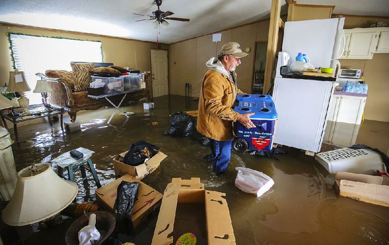
Many were still to face the aftermath of the floods.
At the Toad Suck Dam along the border of Faulkner and Perry counties Wednesday, dozens of people watched the fast-moving, rising floodwaters from the Arkansas River. Many were sightseers, some taking pictures; a few were filling sandbags.
Others like Julie Burgess stood by helplessly, just hours after evacuating their homes on the Bigelow side of the dam.
"I got out barely at 4:30 this morning, pushing the water with the bumper of my car," Burgess said as she stood along the levee with her brother, Charles Spears.
Her house wasn't flooded when she fled, but she knew it would be soon. Earlier she had evacuated her horse Bay Rum, her Great Pyrenees dog Bubba and her cat Boo Boo.
Burgess, who lives alone, is staying with neighbors in a house not yet flooded along the levee.
She left the home where she'd lived since 1992 with "just a suitcase full of clothes," leaving behind family pictures and items that had once belonged to her mother.
"Everything that I own is in that house, a lifetime," she said, nervously smoking a cigarette.
The flood this year, she said, is "comparable to 1990" and is worse than the one residents endured earlier this year.
Burgess said she lives "month to month" and doesn't know what lies ahead. She doesn't know how badly her house will be damaged, and she said she doesn't have flood insurance.
Because her neighborhood, which sits on the west side of the levee, was reassigned "floodway" status instead of "floodplain" status after she moved there, she said, the insurance is so high she can't afford it -- about $8,000 a year.
"I don't know what I'm going to do," she said more than once.
"Why haven't they improved the levee?" she asked.
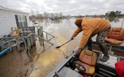
In downtown Fort Smith, a public pavilion just off Riverfront Drive was submerged, said Aqib Kenoly, county emergency management deputy director. Fort Smith Park was completely underwater, and some stores -- including East Side Liquor on Rogers Avenue, a flea market and a vacant building -- had water damage, he said.
A residential area known as Riverlyn Subdivision was closed off to the public after roads were inundated, he said. Kenoly estimated that some six or seven homes were destroyed by flooding -- meaning the homes were submerged by between 2 and 4 feet of water -- in the subdivision. They were homes that had been affected by two storms earlier this year, he added.
Many residents in the neighborhood had prepared for the storm, moving belongings to higher ground or to another property, Kenoly said. Some had sheltered in place on a second floor, while others stayed with friends or family.
Other homes in and near Lavaca had up to a foot of water, he said.
Kenoly said that since Sunday the county has rescued four or five people during the storms and floods. All have included minor injuries but no fatalities.
Buffalo River National Park said Wednesday that the waters receded enough for canoeing and kayaking, but the river crossings in the Erbie area are impassable.
"The park is open, the river is open, the trails are open," said C̶l̶a̶r̶k̶ ̶C̶a̶v̶e̶n̶ Caven Clark,* the park's chief of interpretation and research management. "The restrooms are flooded out. This flood in terms of overall volume is in the top five historically."
The restrooms need to be pumped, cleaned and refitted, C̶a̶v̶e̶n̶ Clark said, adding that the staff will go back to work early Jan. 10. Park officials are still trying to gauge the damage, especially in less-traveled areas of the Buffalo, he said.
Counties farther downstream along the Arkansas River were in preparation mode.
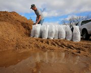
Faulkner County residents needing sandbags can pick up the bags and fill them with sand at the Mayflower Fire Station at 48 Easterwood Point Road, at the south end of Faulkner Meadows Lane just before Arkansas 120 near the pumping station, and at the entrance of Stanford Road off Arkansas 65, county spokesman and attorney David Hogue said.
In Desha County, Judge Roy Rogers said officials were getting sandbags and equipment ready, especially near Pendleton and Arkansas City, which is on the Mississippi River below where the Arkansas River feeds into it.
Officials planned to meet regarding a levee this morning, Rogers said, adding they will probably close it this weekend. Area leaders also have been evacuating deer camps the past couple of days.
The Mississippi River was at 31 feet Wednesday, 6 feet below food stage for Arkansas City, Rogers said. It's expected to crest at 48.5 feet, he said.
"Most of the flooding is above us now, but it's coming fast and furious at us," he said. "I would think, in a couple of days, we're going to start seeing some of the flooding. We're just really kind of sitting and waiting and hopefully praying that something will happen that it will go back down."
Those along the Arkansas River tributaries also were monitoring levee systems Wednesday.
Randolph County Judge David Jansen inspected the Black River levee system in Pocahontas as the river reached 22.5 feet Wednesday afternoon. Flood stage there is 17 feet. The river was first forecast to begin dropping, but water from the nearby Current River has changed projections, and now the river is expected to crest at 24.5 feet Friday.
That's 4 feet below the record mark set in April 2011 when levees breached and flooded homes and businesses and forced the closure of U.S. 67.
"The levees look good now," Jansen said. "The Current River is coming strong and fast, but I hope it won't change the Black River too much.
"If it stays there at 28.5 feet, we'll be in the clear."
Farther downstream, the Black River spilled into thousands of acres of farmland near Black Rock and forced the closure of Arkansas 25 from Black Rock to Powhatan. The river crested at 27.2 feet Tuesday and had dropped to 26.2 feet by Wednesday afternoon.
Water neared the commercial building at Powhatan Historic State Park but never entered it, said Park Superintendent Kristyn Watts. Park officials closed two roads in the park Monday because of the high water from the Black River but reopened them Wednesday.
"The river is flowing," Watts said. "It's slowly going down, but it's brown and muddy. We have a lot of 'looky-loos' coming down to watch it."
In Batesville, the White River began receding, dropping from its crest of 24.15 feet Tuesday to 18.3 feet Wednesday afternoon.
Water still lapped over the gazebo and the stage at Riverfront Park on the northern edge of the White River.
Boat launches and campsites on the southern side of the river remained submerged Wednesday, said Kyle Williford a Batesville Police Department detective.
Williford, along with other Batesville police officers, helped evacuate a dozen people from homes in west Batesville on Tuesday after waters from a creek that runs into the White River overflowed. Williford said water didn't get into the homes but officers used boats to navigate rushing water of over 2 feet to reach the houses.
"It got to the porches but not inside," he said. "It's going down now, but we're still watching the creek."
Water from the confluence of the White and Black rivers north of Jacksonport caused the closure of Arkansas 69 in Jackson County and flooded campgrounds and hiking trails at Jacksonport State Park, said superintendent Mark Ballard.
"The levees are holding," Ballard said. "There's no issues. It's all looking pretty good. It's going to begin falling out real quickly, and we're thankful we don't have any more water on the way."
National Weather Service forecasters are calling for seven to 10 days of dry weather.
Weather service hydrologist Tabitha Clarke of North Little Rock said flooding on the Mississippi River will impede the drainage of the Arkansas River. The release of water from Oklahoma reservoirs and runoff from the White, Black and other rivers will also add water in the Arkansas.
"There are things happening to both ends of the river in the state," Clarke said. "We'll see long, broad crests because it'll be slow to drain."
The Corps said it expects parts of eastern Arkansas to see effects of the bloating in the Mississippi River early next week. The Mississippi near Osceola is expected to reach 42 feet on Jan. 7, 14 feet higher than the flood stage, Corps spokesman Jim Pogue said. The river is expected to rise to 52.5 feet at Helena-West Helena on Jan. 11, 16 feet higher than Wednesday's height.
"It's going to high," he said, "but it's not going to be Armageddon I hope."
Metro on 12/31/2015
*CORRECTION: The Buffalo River National Park’s chief of interpretation and research management is Caven Clark. His name was incorrect in this story.