The Arkansas Game and Fish Commission's Arkansas Water Trails program provides maps and directions for paddling day trips on nine streams scattered across the state.
Directed by Kirsten Bartlow, who is also the commission's director of Watchable Wildlife, the program is meant to encourage canoeing and kayaking for various levels of paddling skill.
Bartlow had planned a dedication ceremony for the new Grassy Lake Water Trail on May 16, but Bell Slough Wildlife Management Area is at Mayflower, where damage left by an EF4 tornado April 27 is still being cleared away. With winds estimated at 180 to 190 mph, the storm resulted in 16 deaths across three counties, injured dozens of people and shattered homes and businesses.
It passed north of the trail, but Bartlow canceled the ribbon-cutting: "We don't want to pull staff from cleanup efforts or be disrespectful of what has happened in that area," she said.
Although traffic to Bell Slough WMA no longer interferes with storm cleanup, she hasn't rescheduled. But given recent rainfall, the trail is ready to float. The commission's webmaster was working last week to post instructions and a map at agfc.com under "Education," "Education Programs" and "Arkansas Water Trails."
If the map isn't available there today, Bartlow says, she will email it to anyone who writes her at [email protected].
IF YOU GO
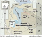
The access isn't hard to find.
While it's possible to join Grassy Lake Road near Mayflower by turning east off Arkansas 365 and passing below Interstate 40, a new frontage road on the east of I-40 isn't so prone to flooding.
After turning east at I-40's Exit 135, take Interstate Drive, the first right turn past the exit. Go south on Interstate Drive for 2.27 miles (passing Mayflower RV and Gibson Bridge Road on the left) to the stop sign where gravel Grassy Lake Road merges and takes over.
Go forward, following Grassy Lake Road across Palarm Creek and past the R. Kenny Vernon Nature Trail trailhead parking.
About 3.9 miles from Exit 135, turn left (some maps label this bit "Grassy Lake Road" and some use "Camp Joseph Robinson": just remember to go left). Veer left again past the turn to Rotunda Circle.
At about 4.17 miles from Exit 135, you'll reach a Y. Stay right on Grassy Lake Road and you'll rattle into the access lot in three-tenths of a mile.
The other Arkansas Water Trails are at Arkansas Post in Arkansas County, the Arkansas River in Sebastian County, Bayou DeView and Robe Bayou in Monroe County, Crooked Creek in Marion County, Cut-Off Creek in Drew County, Little Maumelle River in Pulaski County and Wattensaw Bayou in Prairie County.
ActiveStyle on 06/09/2014