A much wider area of Arkansas is at risk for increased earthquake activity than originally believed, according to a new U.S. Geological Survey seismic hazards map that highlights where temblors are likely to occur over the next 50 years.
The survey released an updated map last week for the first time since 2008. The seismic map includes research into several recently discovered fault systems in Arkansas and data of the ground's movement taken by more sophisticated seismographs.
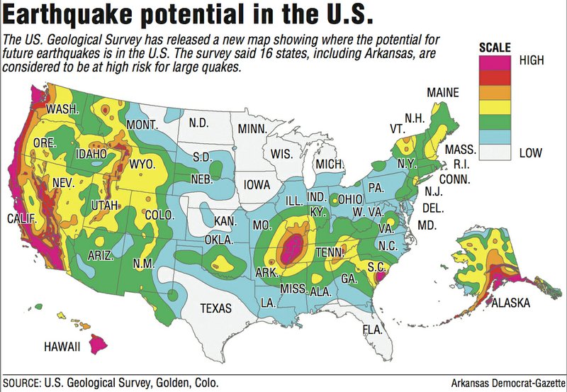
The map is used for developing emergency management mitigation, for building codes and for insurance purposes.
"The New Madrid Seismic Zone has always been there," said Robert Williams, the coordinator of the survey's Central and Eastern U.S. Earthquake Program in Golden, Colo., referring to a series of faults that run from southern Indiana to northeast Arkansas. "But new research has shown other faults outside of that zone, so we've broadened the area of future intensity.
"The next big earthquake [in the central U.S.] may not be right on the New Madrid," he said.
Along with Arkansas, the map indicates that the western half of the United States and portions of the Eastern Seaboard have an increased risk of "very intense shaking," Williams said.
"Intense shaking" is considered between 6.8 and 8.0 in magnitude, Williams said.
The map shows that 42 states have a "reasonable chance" of damaging ground shaking within the next 50 years, according to a statement from the survey. Sixteen states, including Arkansas, are considered to have the highest risk of such shaking.
The other states are Alaska, California, Hawaii, Idaho, Illinois, Kentucky, Missouri, Montana, Nevada, Oregon, South Carolina, Tennessee, Utah, Washington and Wyoming.
"There's a larger bull's-eye on north-central Arkansas than what was there on the previous map," said Scott Ausbrooks, geohazards supervisor for the Arkansas Geological Survey. "The map takes into account the recent surrounding seismicity, along with historical information."
Ausbrooks said the recent addition of seismic monitoring systems in Faulkner and Van Buren counties has shown increased activity in north-central Arkansas. Gas drilling companies there injected wastewater into deep wells during the past few years that were tied to quakes.
The hazard map notes man-induced seismicity, such as the quakes in parts of Arkansas and in central Oklahoma, where drilling operations are ongoing, but does not consider them when evaluating hazard risks, Ausbrooks said. It does include other natural active fault systems discovered in the area near Greenbrier and Guy, along the Missouri-Arkansas border and near Memphis, he said.
The map also includes the 2011 discovery that at least two major earthquakes rumbled beneath Lee County between 4,800 and 10,000 years ago. Geologists dug into a cotton field south of Marianna three years ago and found evidence of "sand blows," or liquefied Delta soil, that blasted during vast earthquakes.
Williams was part of the geological team that inspected the sand blows.
"We know that it came from a different fault than the New Madrid," he said. "The evidence showed that it was from much older events, too."
The New Madrid Seismic Zone triggered three devastating earthquakes in the winter of 1811 and in the early months of 1812. Scientists estimate the temblors were up to 8.0 in magnitude -- the largest earthquakes ever to strike the continental United States.
Nonetheless, "Those who are worrying about quakes larger than magnitude 7.0 happening don't have the right plan," Williams said. "It's more likely that a 6.0 would hit the region, and that would still be a major problem.
"Seismic energy in the eastern U.S. travels much further," he said. "The earth's crust is more dense in the central U.S. The rocks don't dissipate the energy as much as they do in California. A 6.0-magnitude earthquake [in the central United States] would affect 10 times more an area than a 6.0 in California."
Poinsett County Office of Emergency Management coordinator Frank Kraft said he is developing a new earthquake mitigation program for his county and will use the survey's new hazards map.
"The epicenter of the [1811] quake was near Marked Tree," Kraft said, referring to the town of 2,800 in eastern Poinsett County.
"I think people are ignoring the potential danger. It happened a long time ago, and people now think the fault is inactive. That's the furthest thing from the truth."
Williams said the survey included detailed research into a 5.8-magnitude earthquake that struck Virginia in 2011, which was one of the largest to occur along the East Coast in the past century.
The potential for earthquakes also increased near Charleston, S.C., after assessments of previous quakes in the state, he said.
About 10 percent of the country shows a decrease in hazards in the new map compared with the 2008 version, Williams said. In New York, the map indicates a slightly lower hazard for tall buildings than previously thought because research showed that earthquakes there tend to be fast-shaking, which is more apt to affect shorter structures.
Geologists also increased the hazards in California because of the discovery of new faults near San Jose, Vallejo and San Diego.
Officials updated building codes in 2012 to include new seismic data, Ausbrooks said. It may take six to eight years before the survey's latest maps are incorporated into new codes, he said.
In a news release, Jim Harris, a member and former chairman of the Provisions Update Committee of the Building Seismic Safety Council, said the committee values the survey's information.
"The standards for seismic safety in building codes are directly based upon [the survey's] assessments of potential ground shaking from earthquakes, and have been for years," Harris said in the release. "The committees preparing those standards welcome this updated ... information as a basis for making decisions and continuing to ensure the most stable and secure construction."
Ausbrooks said he hopes the survey's new maps will make residents more aware of the potential for earthquakes in Arkansas and better prepare them.
"It's going to get people talking," he said.
State Desk on 07/21/2014