TUPELO, Miss. - At least three fatal tornadoes splintered homes and businesses in Mississippi and Alabama on Monday, part of a powerful storm system that threatened large areas of the South with more twisters, severe thunderstorms, damaging hail and flash floods, authorities said.
In Mississippi, officials said up to seven people had been killed. Mississippi Department of Health spokesman Jim Craig said Monday night that officials were working with coroners to confirm the total.
Earlier Monday, Lee County Coroner Carolyn Gillentine Green confirmed a woman died Monday in a traffic accident during the storm in Verona. Green said it wasn’t clear yet what caused the wreck.
In northern Alabama, Limestone County Emergency Director Rita White said the coroner’s office had confirmed two deaths in a twister that caused extensive damage west of Ath-ens. White said more victims might be trapped in the wreckage of damaged buildings, but rescuers couldn’t reach some areas because of downed power lines.
Separately, Limestone County Commissioner Bill Latimer said he had reports from a worker of at least four deaths in the county, but officials had not yet confirmed those deaths.
Earlier Monday, injuries were reported in Tupelo, a community of about 35,000 in northeastern Mississippi, and in Louisville, the seat of Winston County about 90 miles northeast of Jackson, where about 6,600 people live, Craig said.
People in the path of the huge system were on edge as the National Weather Service posted tornado watches and warnings around Mississippi, Tennessee, Alabama and Georgia. Forecasters said the system was the latest onslaught of severe weather that triggered deadly tornadoes in Arkansas and Oklahoma on Sunday and has threatened flash floods, damaging hail and dangerous thunderstorms across the South.
Mississippi Gov. Phil Bryant earlier Monday declared a state of emergency in advance of the expected bad weather.
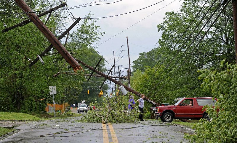
In Tupelo, every building in a two-block area south of U.S. 78 had sustained damage, officials said. Some buildings had their roofs sheared off, and power lines had been knocked down completely or bent at 45-degree angles.
Deborah Pugh, spokesman for the Northeast Mississippi Medical Center in Tupelo, said the hospital received 24 patients. She said 20 had minor injuries and were expected to be treated and released. She said four others were undergoing further evaluation.
The tornado in Louisville caused water damage and left holes in the roof in the back of the Winston Medical Center, where the emergency room and outpatient clinic are located. There were about 15 patients in hospital rooms and eight or nine in the emergency room, where evacuations were underway, University of Mississippi Medical Center spokesman Jack Mazurak said.
Altogether, 45 people were injured in Louisville, but no deaths had been reported, Mazurak said.
“We thought we were going to be OK, then a guy came in and said, ‘It’s here right now,’” said Dr. Michael Henry, head of the emergency room. “Then boom … it blew through.”
From Memphis, officials declared a state of emergency in a county southwest of Nashville, Tenn., because of flash flooding. Authorities urged people there to seek higher ground after several homes and some business were flooded in Maury County, and officials reported worries that some school buses couldn’t get schoolchildren home over swamped roads.
The National Weather Service issued a tornado watch Monday for most of north Alabama, and the entire state was under a flash-flood watch. Tornado warnings began popping up on weather maps in Alabama as soon as storms crossed the Mississippi state line Monday afternoon. Alabama Gov. Robert Bentley declared a state of emergency in response to the storm Monday evening.
More than 50 school systems shut down early in Alabama’s northern half as a precaution against having children and workers on the road in buses and cars when the storms arrived. Several cities closed municipal offices early.
Police said dozens of people gathered in a community storm shelter in Haleyville, about 80 miles northwest of Birmingham, as storms approached. A scientific team from the University of Alabama in Huntsville tweeted a photo of an apparent tornado forming in Russellville.
About 7,100 homes and businesses were in the dark Monday throughout Alabama.
The threat of dangerous weather rattled nerves a day after the three-year anniversary of a historic outbreak of more than 60 tornadoes that killed more than 250 across Alabama.
George Grabryan, director of emergency management for Florence and Lauderdale County in northwest Alabama, said 16 shelters opened before storms even moved in and people were calling nervously with questions about the weather.
“There’s a lot of sensitivity up here,” Grabryan said. “I’ve got a stack of messages here from people, many of them new to the area, wanting to know where the closest shelters are.”
Forecasters earlier said the system moving into Alabama could generate tornadoes with strength ratings of EF3 or higher and damage tracks 30 miles long or worse.
While the severe weather might not be as widespread as the April 27, 2011, outbreak, the possibility of twisters after nightfall heightened the threat, some said.
“From my perspective the nighttime tornadoes are the worst-case scenarios,” said John De Block, a National Weather Service meteorologist in Birmingham.
Elsewhere, forecasters warned Georgia residents of a threat of tornadoes in northern, central and western counties, including metropolitan Atlanta.
The pattern of severe weather may continue today and Wednesday, and portions of north and central Georgia could see some flooding, with 3 to 5 inches of rainfall in this week’s forecast.
A flash-flood watch issued by the National Weather Service covered most of Georgia.Forecasters warned the intensity of thunderstorms was expected to increase Monday night through Wednesday. Flooding was a possibility in streams, creeks and rivers, forecasters said.
The approaching storm prompted the Georgia Emergency Management Agency to plan launching its state operations center at 9 p.m. to monitor weather conditions.
“We bring people in to staff positions just to help expedite any requests for assistance,” agency spokesman Ken Davis said. “We’re on heightened alert, basically.”
Davis added that the agency had contacted all of its emergency support partner agencies, and officials were urging Georgians to prepare for the storm and check weather forecasts regularly.
“The first thing people should do in the morning if the threat doesn’t present itself tonight is to check the forecast,” Davis said Monday. “It could be potentially treacherous tomorrow morning.”
A strong storm barreling through southeastern Kentucky on Monday damaged homes and businesses and left more than 6,000 customers without power, Harlan County Emergency Management Director David McGill said. No injuries were reported.
Officials said Monday that a deadly twister that hit Quapaw, Okla., the night before formed too quickly for a tornado warning to be issued or for warning sirens to be activated.
According to state emergency management officials, sirens usually are sounded once a tornado warning is issued for a county. But officials said the tornado that hit Quapaw, killing one person and sending six to the hospital, materialized so quickly on the radar that a warning was not issued in time.
Officials added that the sirens didn’t activate during or after the storm because they were damaged by the tornado.
Oklahoma Gov. Mary Fallin toured tornado-ravaged Quapaw on Monday, telling residents the state had issued an emergency declaration to kick-start cleanup and rebuilding efforts.
One man, 68-year-old John Brown, of nearby Baxter Springs, Kan., died when a concrete wall fell on his car, and six others were reportedly taken to hospitals with injuries. Fallin said the tornado that struck about 5:30 p.m. Sunday also destroyed Quapaw’s fire station and at least five businesses and other structures.
After hitting Quapaw, the twister continued north into Kansas and struck Baxter Springs, about 5 miles away. Cherokee County, Kan., emergency manager Jason Allison said 60 to 70 homes and 20 to 25 businesses were destroyed. No deaths were reported in Baxter Springs.
Bill Davis, a meteorologist in Springfield, Mo., said tornado sirens didn’t sound in Baxter Springs until right before the twister hit the town because of how quickly it formed.
“That’s what happened in Quapaw, too,” Davis said. “It’s that worst-case scenario where a tornado forms right in a populated area. It was within a minute of the warning.” Information for this article was contributed by Jay Reeves, Jack Elliot Jr., Janet McConnaughey, Phillip Lucas, Russ Bynum, Adrian Sainz, Jeff Amy, Emily Wagster Pettus, Bailey Elise McBride, Roxana Hegeman, Bill Draper and staff members of The Associated Press and by Alan Blinder, Mokoto Rich, Manny Fernandez,Trevor Graff and Ashley Southall of The New York Times.
25880758
Front Section, Pages 1 on 04/29/2014