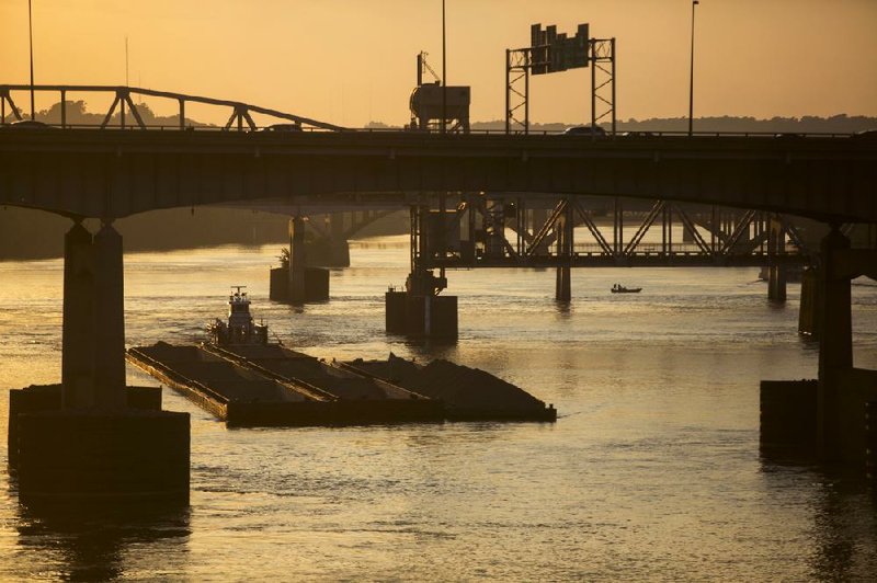
The barge mishap that disrupted downtown traffic late last month would happen more often if not for the skill of the boat captains who must negotiate their barges and vessels under a series of bridges in downtown that include the Interstate 30 bridge,which features the narrowest channel on the Arkansas River navigation system, according to a veteran towboat operator.
“It’s not because it’s not dangerous,” said Mike Metzler, a towboat captain who runs Little Rock Harbor Service and used his towboat, the MV Harry V. HastingsSr., to help round up some of the errant barges that night. “It’s because of the skill of the operators. It’s definitely a tight fit.”
Federal, state and local agencies responded Aug. 24 after one of 12 barges being pushed down the river hit one of the I-30 support structures, and the wire cable connecting the barges to their tow vessel snapped, causing some of them to float freely and scrape the pier protectors on the I-30 and Clinton Presidential Park bridges.
Police blocked access to the I-30, Main Street and Broadway bridges briefly that night, causing traffic to back up for as much as a half-mile on the North Little Rock sides of the bridges before officials conducted a preliminary inspection and reopened them to traffic.
The barges began to float adrift after one of them struck a protective structure at the base of the I-30 bridge, said Lt. j.g. Brian Porter, a spokesman for the U.S. Coast Guard Sector Lower Mississippi River. The widest of the bridge’s two navigation channels between its piers is more than 120 feet narrower than the other bridges in the downtown area.
In the configuration that the barges were in on the river, three across and four rows deep, the barges together stretched 105 feet across and 800 feet in length, according to Metzler, who has been working on the river for more than 40 years. The vessel towing them added another 138 feet. Together, the 938 feet is 154 feet shorter than the USS Nimitz, a U.S. Navy aircraft carrier considered one of the largest warships in the world.
There are four other bridges in the vicinity of the I-30 bridge. Each of those bridges, which include the Broadway bridge and the Main Street bridge, which primarily carry vehicles, have navigation channels that are 300 feet wide or more.
But because the bridges are so close to the I-30 bridge, the width of their navigation channel isn’t a factor in downstream barge traffic because the towboat operators must set their barges up to pass under the narrow channel of the I-30 bridge, according to Metzler.
The I-30 bridge actually has two navigation channels. What is considered the main navigation channel has an “actual navigable width” of 174.5 feet, said Danny Straessle, a state Highway and Transportation Department spokesman. The other channel has an “actual navigable width” of 169 feet.
The latter navigation channel, which is on the north side of the pier in the middle of the channel, is considered the alternate channel by the Highway Department. But Metzler said it is the channel towboat operators most often use to negotiate the I-30 bridge because of the way the barge tows must be set up.
Going downstream, the barge tows set up on the north side of the wider channels under the other bridges, hugging the piers of each of the bridges to set up to cross under the I-30 bridge because the tows are so long that the stern of their vessel is still under one bridge while the bow of the front barges is under another bridge, Metzler said.
Metzler, a former chairman of the Arkansas Waterways Association, has highlighted the navigation difficulties at the I-30 bridge for years.
After the barges broke loose on Aug. 23, the Coast Guard helped round up the barges and began an investigation that should last about six months, Porter said. They questioned the captain of the towboat, who was also tested for drugs and alcohol, Porter said. Porter would not release the captain’s name or discuss the specific details of the investigation.
Speaking generally, he said incident investigations can lead to license revocations and, at times, criminal charges if investigators determine human error or negligence were contributing factors.
The towboat is owned by Ingram Barge Co. of Nashville, Tenn. A spokesman for Ingram Barge Co. said last Monday that the boat was leased and operated by Inland Marine of Hebron, Ky. All of the barges were recovered.
One was deemed too damaged to travel, and workers transferred its contents to another barge before the barges were reassembled and sent on their way to their destination in Rosedale, Miss., Aug. 25, Porter said.
Employees with the Highway Department’s heavy bridge division who viewed the contact sites Monday were confident that the bridges are safe and that the protective cells that surround the bridges’ piers didn’t need repair.
The protective cells, installed a dozen years after the bridge was built, are large structures. All six - one upstream and one downstream to protect each of the three piers of the I-30 bridge in the navigation channel - are 40 feet in diameter. Because the surface below the river is uneven, they have different heights, ranging from 55.6 feet to 67.6 feet in height.Each are deeply embedded in the river floor, ranging from 19.5 feet to 33 feet.
All six are filled with rock. The estimated volume of rock in each cell ranges from 1,551 cubic yards to 1,804 cubic yards, according to department figures. All told, the six cells contain nearly 10,000 cubic yards of rock. Each cell also has a concrete cap, said Randy Ort, a spokesman for the Highway Department, said.
Officials had hoped that the narrow channel at the I-30 bridge would be addressed when state highway officials replaced the bridge, but that isn’t going to happen. Under the latest plans, the bridge will be widened as part of a larger project to widen the I-30 corridor between its interchange with I-40 in North Little Rock and Interstate 530 in Little Rock.
The project, estimated to cost $300 million, is part of a highway construction program that will be financed, in part, from a half-percentage-point increase in the statewide sales tax. Voters approved it last November.
The bridge, which opened to traffic in 1958 and cost $5.5 million, carries 124,000 vehicles per day, according to Highway Department figures.
“The only way you’re going to do anything for the navigation channel is a full replacement,” Ort said.
Ort said the navigation channel is at an approved width. But Metzler said, “You could never get that approved today.”
Front Section, Pages 1 on 09/02/2013