Storm blamed for Springdale death; more severe weather possible Tuesday
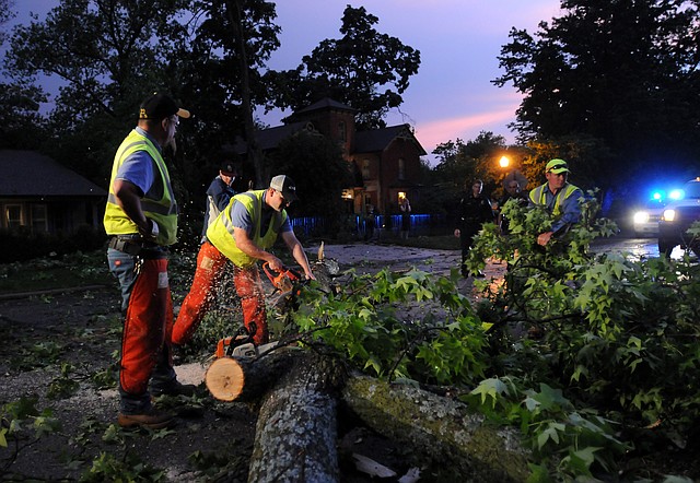
Workers from the Bentonville Street Department use chainsaws to cut down and clear a tree which broke off and fell into East Central Avenue at 305 E. Central Ave. in Bentonville.
Tuesday, May 21, 2013
Bentonville calls for service
Bentonville calls for service following Monday's severe storms.
Officials say one person was killed in Springdale on Monday night when a storm packing winds of nearly 70 mph threw a street sign into the victim's vehicle.
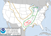
More chances for severe weather in Arkansas are possible Tuesday as a "potent" system capable of producing tornadoes, damaging winds and large hail moves in, the National Weather Service said.
Arkansas State Police say the deadly accident happened about 7:30 p.m. Monday as 19-year-old Austin Wayne Deere, of Prairie Grove, was driving a Honda Accord west on U.S. 412 near Robinson Road.
According to a preliminary report, high winds blew down a street sign and then sent it into Deere's car. He was pronounced dead at the scene.
The fatality is included in National Weather Service reports about the ongoing storm system. Winds in Springdale were measured at 69 mph about the same time the accident occurred.
Robert McGowen, director of the Benton County Emergency Management Agency, said there were no deaths in Benton County.
Falling trees blocked roads and caused home damage in Bentonville.
A large tree on the Bentonville square lost almost all its limbs and will have to be cut down, said David Wright, director of the city’s Parks and Recreation Department. The city also lost an old tree at Dave Peel Park.
“The square and Dave Peel Park were the hardest hit for us,” he said. “Everything else is recoverable.”
Crews from the Electric Department worked through the Monday night to ensure Bentonville residents had power.
Bentonville residents walked and drove through neighborhoods Monday night helping their neighbors clear debris from roofs and yards. Others walked around with their cell phone taking photos and video of the damage.
The repetition of storms in Benton County is stretching city workers thin. Staff are still cleaning up from two floods over the past month.
“We’ve got high grass at our parks right now because we’re still just trying to put our trails back together,” Wright said. “We’ve had two floods and now this.”
Donnie Coleman, Washington County road superintendent, said there were some trees down on roads in Tontitown but no significant problems from the storm.
The weather service says showers and thunderstorms are expected to redevelop later Tuesday morning and into the afternoon as a "potent storm system" moves in.
"Any thunderstorms that do develop will have the potential to become severe with high levels of instability and moisture in place," the agency said in a statement. "The main threats with the strongest storms will be damaging winds and destructive large hail."
Officials say there is also a risk for tornadoes, particularly in southwest Arkansas, because of the "combination of instability and low level shear."
Flash flooding is also a concern, with some places likely to see several inches of rainfall in a short time. Flash flood watches are in effect for much of the central and northern parts of Arkansas.
Elsewhere in Arkansas overnight, a camper and mobile home were blown over southeast of Steprock in White County, trees and power failures were reported near Blue Eye in Carroll County and power poles were down near Heber Springs. Trees were reported down near Sims in Montgomery County, London in Pope County, Vilonia in Faulkner County and at the airport in Little Rock.
McGowen, the Benton County emergency administrator, said most of the reports coming into that agency were of damage from straight line winds.
McGowen said the agency had not received any reports of flooding, although he noted that more rain is in the forecast.
"The places we usually get feedback from police and fire we haven't heard from yet," he said.
Scott Stober, the county's public services administrator, said the Road Department was working to clear away trees that had blocked roads and brought down power lines.
"We've had lots and lots of tree calls, lots of power lines that were down with trees," Stober said. "That's all we're doing right now. We had about one-third of the crew out last night and the other two-thirds working today."
Stober said the Road Department was working calls on Lime Kiln Road, Shady Grove Road, Tanglewood Road, Linville Road and Twin Coves Road. He said the Road Department waits until the electric company has arrived to make certain it's safe to work.
Josh Billis, the county's director of emergency communications, said the BC Alert system functioned normally through Monday night's storm, but said some AT&T customers had problems and did not receive text messages. Billis said the county posted a notice of the problem on its Facebook page Monday and is working with Cooper Notification, which developed the BC Alert system, on a temporary solution. He said finding a permanent solution will be up to AT&T.
About 2,000 Carroll Electric customers remained without power on Tuesday morning. Nancy Plagge, corportate communications director, said a transmission line that powers five substations in eastern Benton County went down during the storm, knocking out power to about 20,000 customers. Plagge said electricit was restored to most customers within two hours.
Just under 1,000 customers remained without power in Garfield on Tuesday, as well as 626 in Prairie Creek and another 300 scattered throughout the service area. Plagge said most of the outages were caused by lightening or high wind causing trees to fall into power lines. The company is also dealing with about 10 broken poles.
“We anticipate we will get everybody restored today,” Plagge said. “We are continuing to work on it.”
Rogers Fire Chief Tom Jenkins said firefighters responded to about a dozen calls of tree limbs down during the height of Tuesday night's call.
The most damage reported was to outbuildings at Garner Building Supply, 125 E Locust St., which sustained roof damage.
Firefighters responded to about 30 calls related to power lines during the storm, in addition to two house fire calls which were electrical and did not cause structural damage.
Jenkins said he had upped staffing in anticipation of the storm.
