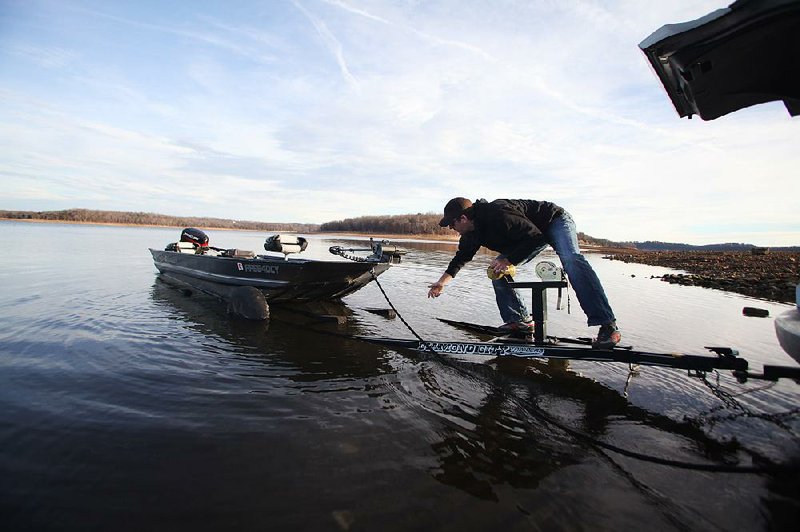
ROGERS — About an hour after the sun rose Friday over Beaver Lake, Chris McClinton of Fayetteville gingerly balanced on the hitch behind his car, working to launch his bass boat without getting his feet wet.
“It can be a real pain just getting the boat in when the water’s this low,” McClinton said.
He planned to spend the morning fishing for striped bass with college friend Jake Russell, also of Fayetteville. After a few minutes of priming the boat’s outboard motor, the pair left the launch ramp on Arkansas 12 east of Rogers and motored out into thelake. They had to maneuver around long gravel bars exposed by the dwindling water level.
A gravel bar extends out from Bear Island, in the portion of the lake nearest to Rogers. A person could almost walk the entire 1,500 feet across without getting his socks wet.
But, state water officials say any panic over the low water level is premature.
Bob Morgan, manager of environmental quality at the Beaver Water District, said the lake is still far above the level at which the U.S. Army Corps of Engineers would consider any rationing of water.
“It’s time to watch it, but not time to be concernedabout it yet,” Morgan said.
The lake, created when the state dammed the White River in the mid-1960s, provides hydroelectric power for the Southwestern Power Authority and drinking water for 18 communities in Northwest Arkansas, from Bella Vista to West Fork. It is also used for recreational activities, including fishing and swimming. The lake, which tops out at 1,130 feet above sea level, now is at about 1,108 feet.
It’s at about 67 percent of capacity.
The Corps of Engineers uses four levels of graduated drought designations to monitor water levels in repositories like Beaver Lake. On the basis of the level of the lakeand on the Palmer Drought Severity Index, developed by the National Oceanic and Atmospheric Administration, officials now place the Beaver Lake District at Designated Drought Level 1, meaning drought conditions have persisted for fewer than 12 months and the water level is between 1,105 and 1,120 feet above sea level.
Henry Himstedt, chief of the Corps of Engineers hydrology and hydraulics division in Little Rock, said Level 1 indicates that the lake merits monitoring.
“We’re monitoring conditions, collecting data, reporting the drought status through the chain of command up toWashington, and participating in weekly national drought coordinating phone calls,” Himstedt said.
At Level 2, triggered if the lake drops below 1,105 feet and drought conditions persist for longer than 12 months, the Corps would form an internal drought-management committee to coordinate informally with other state agencies and work to make sure the lake’s water is allocated in accordance with Beaver Lake District priorities.
Those priorities include hydropower generation and ensuring a clean water supply for residents, with fishing, wildlife and recreation considered ancillary.
Himstedt said the likelihood of Beaver Lake moving into Level 2 depends entirely on rainfall.
“The critical thing is going to be spring into summer,” he said. “If we don’t get sufficient rain to recharge the lake, we’ll be starting the summer near a Level 2 category, with very low rainfall and very little on the horizon.”
Drought Level 3 is triggered when drought conditions persist for two years and the lake drops to 30 percent of capacity. That would activate an interagency drought committee to determine critical water needs and allocate the water accordingly. Level 4 kicks in when a lake gets below 10 percent of capacity and drought conditions have persisted for three years.
“At that point, you’re down to meeting the emergency needs of water supply and hydropower use,”Himstedt said.
Neither Level 3 nor Level 4 have been reached since the Designated Drought Level System was implemented in 1989, and Level 2 was implemented only once, briefly, when Beaver Lake dropped to about 1,105 feet above sea level in March 2006, Himstedt said.
He said the Designated Drought Level System was implemented in reaction to the severe drought in 1988.
Ed Swaim, water resources division manager at the Arkansas Natural Resources Commission, said the level of Beaver Lake is less significant than are the water levels in communities’ wells and water tables that are used for drinking water and crop irrigation.
“We’re concerned after last year’s drought and the lack of rain in 2012 to build us up to where we need to be,” Swaim said. “We’ve talked to a lot of people about on-farm reservoirs for irrigation - they’re low to empty.”
The commission conducts an annual survey of about 1,000 wells around the state, and helps finance water and sewer projects, particularly in areas not served by large reservoirs like Beaver Lake.
Swaim said part of the commission’s mission is to address long-term water concerns by way of the Arkansas Water Plan, which projects supply and demand through 2050.
The challenge is trying to predict the weather years ahead of time. “What do we prepare for?” he said. “Based on the past few years, we’ll get slammed with droughts and floods at the same time. So we have to prepare for a lot.”
Northwest Arkansas, Pages 7 on 01/12/2013