Bing! I had mail.
Off the Beaten Path Series #132: Do you have plans weekend after next?
I did have plans. However, as I read the email from Sherwood resident Bill Steward about a planned backpacking trip into the Greasy Creek drainage, I adjusted my schedule. This part of the Hurricane Creek Wilderness is one of the true jewels of the Natural State.
I met Steward and company at the parking lot of Deer High School, home of the Antlers, on Arkansas 16 in Deer.
Our group included his wife, Dana, Little Rock resident Marion Fulk and three hikers Fulk had met on a Sierra Club backpacking trip in Wyoming’s Wind River Range. From the school, we drove about five miles south on Newton County Road 7410 and parked the vehicles.
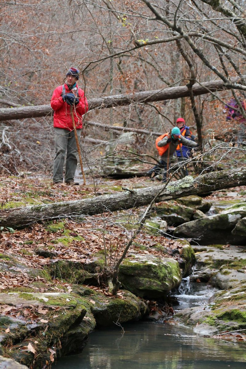
Fulk’s friends were new to bushwhacking.
When Steward saw Tina Linquist and her daughter Bianca adjusting their aluminum trekking poles, he offered each of them a sturdy wooden staff he had crafted from persimmon branches.
Linquist replied that she had her poles, but he matter-of-factly advised her, “These will work better where we are going.”
Our goal for the first day was to explore the upper watershed of Greasy Creek. On earlier trips into this section of the wilderness area, we’d made an easy trek along an abandoned logging road. But since the 2009 ice storm, that route has been cluttered with downed trees and tangled briers. So our backcountry experience began immediately after we crossed the wilderness boundary.
Using a map and compass, we followed a ridge in an easterly direction for a couple of miles, skirting around the creek’s upper watershed.
We then dropped off the rim to set up camp on a bench on the eastern, sloping hillside of Greasy Creek Hollow. Carrying only light daypacks, we then resumed our descent down the steep hillside.
STICKY SITUATION
We faced loose, rocky footing and steep terrain. I watched Dana Steward expertly stab her hiking stick into the side of the mountain then lean hard against it so that her precarious footing was not hampered further by the full weight of her body. Linquist must have witnessed this also, for she began to mimic Dana using the stick Bill lent her.
As we followed a shallow crease down the craggy mountainside, we came upon several small pockets of water. Soon these independent pools joined to form a small, steady stream, which constantly adjusted its course around natural barriers that obstructed its descent. As the volume of water increased, the tributary transcended these obstacles to create a series of babbling, churning cascades.
I was pleased to see that Nature had flushed out most of the downed trees that had crisscrossed the drainage after the ice storm. This made our walk along the creek bed a much more enjoyable experience.
We reached a sort of fortification of large boulders where the stream seeps into its bed and disappears underground. As we scrambled over and around these cabin-size rocks, Bill Steward said that a friend of his had proclaimed this area to be one of the finest “rock forests” he had ever seen.
Continuing down the drainage, we saw the stacked slabs of rock that are the mountain’s innards, exposed by centuries of erosion. In the creek bed, broken slabs created a stair step of 1- and 2-foot ledges that everyone descended with little difficulty. That is, until we encountered a drop too deep to step down.
We had reached the 30-foot ledge of Greasy Creek Falls. An excellent setting, we decided, to enjoy our lunch.
The falls had been the destination for several in our group, and so after the break they turned back. The remainder of us trekked on.
After passing another big drainage from the west, we began to see an impressive display of obviously hand-stacked rocks along the bank. This was a fence, the boundary of the historic homestead of John Pellham.
HILL FOLKS
According to my friend Tom McKinney of West Fork, who has researched the history of the Hurricane Creek area, this was part of the original 160-acre land grant deeded to Pellham in 1904.
Remnants of Pellham’s house still stand at the confluence of Greasy and Hurricane creeks. Judging by the large stack of rocks from the collapsed chimney and a long stone wall bordering the approach, it was an impressive abode.
Pellham also demonstrated impressive foresight by building his house several feet up the hillside on a raised stone platform: The Hurricane Creek watershed floods frequently.
Another cabin once stood farther upstream on Hurricane Creek; it was built by Pellham’s brother, Bill, on the 160 acres deeded to him. And still farther upstream are the remains of Cora Pellham’s cabin.
At one time the area had as many as five cabins full of Pellhams.
SUNDOWN
With the sun setting behind the tall western rim of the hollow, we began our trek back to camp. It was a long, demanding climb up Hurricane Knob out of Greasy Creek; but after cresting the knob we followed an even contour along the mountainside back to camp.
As we feasted family style on Fulk’s homemade chili around our campfire, Linquist allowed that her lightweight trekking poles were not well suited for the stresses of bushwhacking.
The day had also taught her that hiking off-trail requires thicker pants. She showed off several snags in the thin layered pants that she normally wore when trail hiking.
She asked if there were other helpful tips for bushwhacking. She could not have asked a better qualified panel. The Stewards and Fulk, seasoned bushwhackers, have been active members of the Ozark Society’s Pulaski Chapter for many years.
“You know,” Bill Steward began, “there are just certain items I would not venture out into the backcountry without being in my possession. One of these items would be at least two sources of light.”
“I would also include eye protection on that list,” Dana Steward said.
“You should also have a map and compass with you,” Fulk said, “and they might be more helpful if you know how to use them.”
The group tag-teamed a list of assorted advice on preparation for a safe excursion into backcountry: water purifying tablets, GPS devices, matches and Bill Steward’s favorite, a pistol.
The primary purpose of a weapon isn’t protection, he explained. It also comes in pretty handy in an emergency when someone’s too hurt to move. Firing three shots in the air is a universal distress signal. Steward noted that he had been on excursions where he used the signal for assistance and help found him.
PREPARED
Steward has always said that there is no such thing as bad weather, just bad gear. He was proved right once again. Even with the temperatures dropping to a chilly 16 degrees, I was warm and snug in my zero-degree down-filled sleeping bag.
After a hearty breakfast, we broke camp to march up the hill and out of the watershed. At the top of the ridge we stashed our heavy backpacks so we could then drop down the northern slope of the ridge into the Mill Creek drainage.
En route, we hiked through a dense forest of beech trees.Their thick leaves rattled in the breeze with ice droplets clinging to their tips, still frozen from rain two days before. Conditions were perfect for spotting our first frost flowers of the season, thin layers of ice forming exquisite petal patterns around various long stemmed plants.
Clumps of black algae-looking material coated some of the leaves and branches. Scanning the area, we noticed that the growth appeared to be limited to beech trees.
“That is Scorias spongiosa,” Laura Merrick announced. Although not experienced in bushwhacking, she did have her own field of expertise, biology. Around the campfire, she’d told us about her 25 years of studying squash, including investigative travels to Mexico. (I thought she was talking about researching the ancestors of the people who ate the squash, but she said no, she juststudies squash.)
Merrick explained that Scorias is a fungus that grows in secretions produced by a blight aphid that is, indeed, exclusive to beech trees.
We followed an unnamed feeder creek down the lower section of the hillside to reach Mill Creek. The drainage was similar to the one we had trailed down to Greasy Creek. However, there were several round, polished, bowl-like formations in the bedrock ofthis creek, where trapped water had continuously swirled around and around.
Where the little tributary met Mill Creek we found another waterfall taller than 30 feet, providing another excellent setting for our lunch break.
As we lunched on hummus and pita bread provided by Linquist and peppers and dried tomatoes from Merrick’s garden, Bianca asked how we’d known this waterfall was here.
I pointed a finger toward Steward and explained that one day he called me on the phone to say he was looking at squiggly contour lines in the topographic map of the Hurricane Creek Wilderness Area. He felt sure there had to be some really interesting features to see in there.
Actually, many of my outdoor adventures originate with someone studying the lines ona map, searching for close contour lines distorted by sharp bends and turns.
I have been to Greasy Creek on a number of occasions. On each trip I discover enough interesting new features to keep me coming back again. But I have to admit that after two days in subfreezing temperatures, the heat in my car felt pretty good on the drive home.Activities abound in Hurricane wilds
The Hurricane Creek Wilderness is a virtual outdoor playground for hikers, kayakers and other outdoor enthusiasts.
Congress designated the wilderness in 1984 under the Dale Bumpers Wilderness Resources Protection Act. The 15,307 acres in the wilderness are managed by the U.S. Forest Service, as are all 12 wilderness areas in Arkansas.
There are no fees to enter the area and no campgrounds or restrooms. Camping, fishing and hunting (in season) are allowed. Motor vehicles and motorized equipment are not allowed.
Bushwhacking is not required to enjoy the area although map-reading skills are needed. The Ozark Highlands Trail passes through the southern wilderness. Its Fort Douglas trailhead can be found by beginning at the junction of Arkansas 7, 123 and 16 at Pelsor. Turn left (west) on Arkansas 123 and go 14 miles to Piney Creek (crossed by a one-lane bridge). Parkingis at the trailhead.
General information about the area can be found online by searching usdasearch.usda.gov for “Hurricane Creek Wilderness.”
For $9, the Ozark Society sells a topographic map showing the entire wilderness as part of its Arkansas Wilderness Map series. Created in cooperation with the Forest Service, the GPS-friendly paper map uses the standard topographic scale of 1:24,000. More information is under “store” at ozarksociety.net.
ActiveStyle, Pages 23 on 12/09/2013